Kalannie, Western Australia facts for kids
Quick facts for kids KalannieWestern Australia |
|
|---|---|

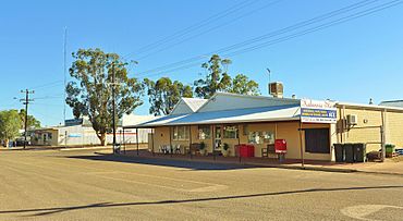
Roche Street, Kalannie, 2014
|
|
| Established | 1929 |
| Postcode(s) | 6468 |
| Elevation | 345 m (1,132 ft) |
| Area | [convert: needs a number] |
| Location |
|
| LGA(s) | Shire of Dalwallinu |
| State electorate(s) | Moore |
| Federal Division(s) | Durack |
Kalannie is a small town in Western Australia. It is located in the Wheatbelt region. This area is famous for growing lots of wheat. Kalannie is about 259 kilometers (161 miles) north-east of Perth, the state capital. It is part of the Shire of Dalwallinu.
History of Kalannie
Kalannie officially became a town in 1929. The name "Kalannie" comes from the Aboriginal people. It means "where Aboriginal people found white stone for their spears." This name tells us a bit about the area's long history.
In 1932, an important development happened for Kalannie. The Wheat Pool of Western Australia decided to build two grain elevators in the town. These elevators help store and move grain. They were placed next to the railway line. This made it easier for farmers to send their wheat to other places.
What Kalannie Produces
The main things produced in Kalannie are wheat and gypsum. Wheat is a very important crop grown in the Wheatbelt region. Gypsum is a mineral used in things like plaster and fertilizer.
Kalannie is connected to a narrow gauge rail network. This means the train tracks are a bit narrower than standard ones. A special branch-line connects Kalannie to the main Amery to Kalannie railway line. This railway helps transport the wheat and gypsum.
The town is also a receival site for Cooperative Bulk Handling (CBH). CBH is a big company that helps farmers store and sell their grain. Farmers bring their harvested crops to these sites. From there, the grain can be moved to ports for export.
 | Aaron Henry |
 | T. R. M. Howard |
 | Jesse Jackson |


