Kalaoa, Hawaii facts for kids
Quick facts for kids
Kalaoa, Hawaii
|
|
|---|---|

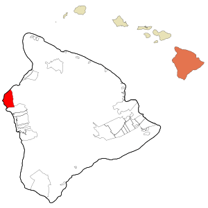
Location in Hawaii County and the state of Hawaii
|
|
| Country | United States |
| State | Hawaii |
| County | Hawaii |
| Area | |
| • Total | 45.6 sq mi (118.1 km2) |
| • Land | 39.2 sq mi (101.4 km2) |
| • Water | 6.4 sq mi (16.7 km2) |
| Elevation | 680 ft (210 m) |
| Population
(2010)
|
|
| • Total | 9,644 |
| • Density | 246/sq mi (95.1/km2) |
| Time zone | UTC-10 (Hawaii-Aleutian) |
| Area code(s) | 808 |
| FIPS code | 15-25400 |
| GNIS feature ID | 2414061 |
Kalaoa is a special kind of community in Hawaii County, Hawaii, United States. It is called a census-designated place (CDP). This means it's an area that the government counts for population, but it's not officially a city or town. In 2010, about 9,644 people lived in Kalaoa. This was more than the 6,794 people who lived there in 2000.
Contents
Where is Kalaoa?
Kalaoa is located on the west side of the Big Island of Hawaii. Its exact spot is about 19 degrees north and 156 degrees west. It is next to Kailua-Kona to the south. The town of Waimea is about 33 miles (53 kilometers) to the northeast.
Kalaoa sits on the lower western slopes of the Hualalai volcano. It stretches all the way west to the Pacific Ocean. The total area of Kalaoa is about 118.1 square kilometers (45.6 square miles). Most of this area, about 101.4 square kilometers (39.2 square miles), is land. The rest, about 16.7 square kilometers (6.5 square miles), is water.
What Does Kalaoa Do?
Kalaoa is home to Mokulele Airlines. This is a small airline that flies between the different islands of Hawaii. Its main office is located at the Kona International Airport, which is also in Kalaoa.
How to Get Around Kalaoa
The Kona International Airport is in the lower part of Kalaoa. This airport is very important for the western side of the Big Island. It helps people travel to and from many nearby places. These include Kailua-Kona, Holualoa, Keauhou, Captain Cook, Waikoloa, Waimea, and the Kohala Coast.
Two main highways serve the Kalaoa area. They are both part of the Hawaii Belt Road. The higher road is called Mamalahoa Highway, also known as Route 190. The lower road is closer to the coast and is used more often. It is called Queen Ka'ahumanu Highway, but many people call it The Queen K or Route 19.
Cool Places to Visit
There are several interesting places to explore in and around Kalaoa:
- Keahole Point: This is a point of land that sticks out into the ocean.
- Natural Energy Laboratory of Hawaii: This lab studies ways to get energy from the ocean.
- Kaloko-Honokohau National Historical Park: This park protects important historical and cultural sites.
- Mount Hualalai: This is a large volcano that Kalaoa sits on.
See also
 In Spanish: Kalaoa para niños


