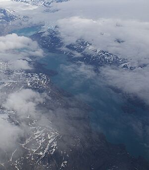
Kangaamiut Kangerluarsuat Fjord facts for kids
The Kangaamiut Kangerluarsuat Fjord (which used to be spelled Kangâmiut Kangerdluarssuat) is a long, narrow arm of the sea. It's found in western Greenland, in an area called the Qeqqata municipality. This fjord is located between two other large fjords: Kangerlussuaq Fjord to the north and Kangerlussuatsiaq Fjord to the south. It eventually opens up into the Davis Strait, which is part of the Atlantic Ocean.
Contents
What is Kangaamiut Kangerluarsuat Fjord?
A fjord is a deep, narrow inlet of the sea. It is often surrounded by high cliffs. Fjords are usually formed by glaciers that carved out the land over many thousands of years. The Kangaamiut Kangerluarsuat Fjord is a great example of this natural process in Greenland.
Where is the Fjord Located?
The Kangaamiut Kangerluarsuat Fjord stretches from its inner end, called the "head," towards the ocean. The head of the fjord is at coordinates 66°00′10″N 52°52′45″W / 66.00278°N 52.87917°W. It flows towards the southwest, eventually meeting the Davis Strait. The entrance to the fjord, where it meets the sea, has many small rocky islands called skerries.
How the Fjord Was Formed
The very end of the fjord is shaped by a smaller icefjord called Illorlersuaq. An icefjord is a fjord that has a glacier at its head. This particular icefjord gets its ice from the Sermitsiaq Glacier. This glacier is a "tidewater glacier," meaning it flows directly into the ocean. The Sermitsiaq Glacier is part of the Maniitsoq ice cap. An ice cap is a large dome-shaped mass of ice that covers less than 50,000 square kilometers. This ice cap is now separate from the main Greenland ice sheet, which is known as Sermersuaq in the local language.
Life Near the Fjord
The only town close to the Kangaamiut Kangerluarsuat Fjord is Kangaamiut. This town is built on a small island. It is located just south of where the fjord opens up to the sea. People in Kangaamiut often rely on the sea for their livelihoods, such as fishing.
 | Emma Amos |
 | Edward Mitchell Bannister |
 | Larry D. Alexander |
 | Ernie Barnes |


