Kappa, Illinois facts for kids
Quick facts for kids
Kappa
|
|
|---|---|

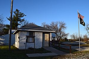
Kappa village hall
|
|

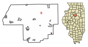
Location of Kappa in Woodford County, Illinois.
|
|

Location of Illinois in the United States
|
|
| Country | United States |
| State | Illinois |
| County | Woodford |
| Area | |
| • Total | 0.36 sq mi (0.93 km2) |
| • Land | 0.36 sq mi (0.93 km2) |
| • Water | 0.00 sq mi (0.00 km2) |
| Elevation | 729 ft (222 m) |
| Population
(2020)
|
|
| • Total | 229 |
| • Density | 641.46/sq mi (247.55/km2) |
| Time zone | UTC-6 (CST) |
| • Summer (DST) | UTC-5 (CDT) |
| ZIP Code(s) |
61738
|
| Area code(s) | 309 |
| FIPS code | 17-39038 |
Kappa is a small village located in Woodford County, Illinois, in the United States. In 2020, about 229 people lived there. It is part of the larger Peoria area.
The first person to settle in the Kappa area was Thomas Dixon in 1833. More settlers arrived over the next few years. A railroad was built through the area, and train service started on May 23, 1853. Postal service also began around this time.
The first postmaster, William Jones, wanted to name the town Montrose. However, the Illinois Central Railroad chose the name Kappa. Kappa is the tenth letter of the Greek alphabet. The town was named Kappa because it was the tenth town along the railroad line between Dunleith (now East Dubuque, Illinois) and Bloomington.
Kappa is located on the north side of the Mackinaw River. Two lakes are nearby: Lake Bloomington is about five miles to the southeast, and Evergreen Lake is about five miles to the southwest.
The original railroad line that ran through Kappa is no longer in use. In the early 1900s, a road called SBI Route 2 was built, which later became U.S. Route 51. Now, U.S. 51 goes around the west side of the town. Illinois Route 251 is the main road that runs north and south through Kappa.
Exploring Kappa's Location
Kappa is found at coordinates 40°40′35″N 89°0′34″W / 40.67639°N 89.00944°W. This helps us pinpoint its exact spot on a map.
According to the 2010 census, Kappa covers a total area of about 0.34 square miles (0.88 square kilometers). All of this area is land, meaning there are no large bodies of water like lakes or rivers within the village limits.
Population Changes Over Time
The population of Kappa has changed quite a bit throughout its history. Here's a look at how many people have lived in the village over the years:
| Historical population | |||
|---|---|---|---|
| Census | Pop. | %± | |
| 1900 | 175 | — | |
| 1910 | 142 | −18.9% | |
| 1920 | 149 | 4.9% | |
| 1930 | 123 | −17.4% | |
| 1940 | 141 | 14.6% | |
| 1950 | 125 | −11.3% | |
| 1960 | 119 | −4.8% | |
| 1970 | 131 | 10.1% | |
| 1980 | 170 | 29.8% | |
| 1990 | 134 | −21.2% | |
| 2000 | 170 | 26.9% | |
| 2010 | 227 | 33.5% | |
| 2020 | 229 | 0.9% | |
| U.S. Decennial Census | |||
In 2000, there were 170 people living in Kappa. These people made up 63 households, with 48 of them being families. The average household had about 2.70 people, and the average family had about 3.08 people.
Many households (47.6%) had children under 18 living with them. Most households (58.7%) were married couples. About 9.5% of households were led by a female with no husband present.
The median age in the village in 2000 was 32 years old. This means half the people were younger than 32 and half were older. About 32.4% of the population was under 18.
The median income for a household in Kappa in 2000 was $46,786. For families, the median income was $50,417.
See also
 In Spanish: Kappa (Illinois) para niños
 | Jackie Robinson |
 | Jack Johnson |
 | Althea Gibson |
 | Arthur Ashe |
 | Muhammad Ali |

