Mackinaw River facts for kids
Quick facts for kids Mackinaw River |
|
|---|---|

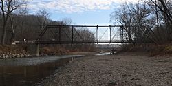
Mackinaw River near Tremont, Illinois
|
|
| Physical characteristics | |
| Main source | Ford County east of Sibley, Illinois 40°35′20″N 88°21′59″W / 40.5889233°N 88.3664421°W |
| River mouth | Confluence with the Illinois River near Mapleton, Illinois 443 ft (135 m) 40°33′06″N 89°43′56″W / 40.5517055°N 89.7323284°W |
| Length | 130 mi (210 km) |
| Basin features | |
| Progression | Mackinaw River → Illinois → Mississippi → Gulf of Mexico |
| GNIS ID | 403283 |
The Mackinaw River is a long river in Illinois, USA. It flows for about 130 miles (209 km) and eventually joins the Illinois River. The area around the river, called its watershed, is huge! It covers about 1,136 square miles (2,942 km²). This land is super important for farming.
Even though there's a lot of farming, the river itself has very clean water. It's home to many different kinds of animals. You can find 60 to 70 types of native fish and 25 to 30 kinds of mussels living here. The river's name, also spelled Mackinac, comes from the Ojibwe word mikinaak, which means "turtle".
About the Mackinaw River
The Mackinaw River starts near Sibley, Illinois, in Ford County. From there, it flows west through McLean County. It helps drain water from parts of the Bloomington–Normal area. Then it continues through Woodford County.
The river keeps flowing west and then turns southwest. It goes through Tazewell County. Finally, it flows into the Illinois River just south of Pekin.
The river flows through three special natural areas. These include the Grand Prairie, the Upper Mississippi River and Illinois Bottomlands, and the Illinois and Mississippi Sand Areas. Many thousands of years ago, after the last ice age (called the Wisconsin glaciation), the river cut through large hills of dirt and rocks called moraines. These moraines changed how the riverbed looks today.
At the top part of the river, you'll find calm pools of water and fast-moving, shallow areas called riffles. But after the moraines, the river changes a lot. It has a wider flat area next to it (a floodplain), big curves, and sandy banks that can easily wear away. The main smaller rivers and streams that flow into the Mackinaw River are Panther Creek, Walnut Creek, Money Creek, and the Little Mackinaw River.
History of the River
People from the Hopewell culture lived near the Mackinaw River a very long time ago, between 1,700 and 2,100 years ago. Later, Native American groups like the Kickapoo, Potawatomi, Chippewa, and Ottawa also lived along the river. They fished, hunted, and made their homes there for many centuries, up until the 1830s. In 1853, about 200 Kickapoo people still lived by the river. However, they were expected to move to a reservation in Missouri the next year.
There are only a few small towns located right on or very close to the Mackinaw River. These include Sibley, Colfax, Lexington, and Mackinaw. These towns were started before railroads came to the area in the 1850s. Once trains became popular, river travel became less important for moving goods and people.
Exploring the River
The Mackinaw River State Fish and Wildlife Area is a large state park along the river. It covers about 1,448 acres (586 hectares) in Tazewell County. The Illinois Department of Natural Resources manages this area. It's a great place to visit! You can go fishing, canoeing, hiking, or hunting. It's also a wonderful spot to simply enjoy nature.
 | Laphonza Butler |
 | Daisy Bates |
 | Elizabeth Piper Ensley |

