
Mackinaw, Illinois facts for kids
Quick facts for kids
Mackinaw
|
|
|---|---|

Former Mackinaw train depot
|
|

Location of Mackinaw in Tazewell County, Illinois.
|
|
.svg)
Location of Illinois in the United States
|
|
| Country | United States |
| State | Illinois |
| County | Tazewell |
| Area | |
| • Total | 1.22 sq mi (3.16 km2) |
| • Land | 1.19 sq mi (3.08 km2) |
| • Water | 0.03 sq mi (0.08 km2) |
| Elevation | 656 ft (200 m) |
| Population
(2020)
|
|
| • Total | 1,879 |
| • Density | 1,580.32/sq mi (610.15/km2) |
| Time zone | UTC-6 (CST) |
| • Summer (DST) | UTC-5 (CDT) |
| ZIP Code(s) |
61755
|
| Area code(s) | 309 |
| FIPS code | 17-45785 |
| GNIS feature ID | 2399217 |
| Wikimedia Commons | Mackinaw, Illinois |
Mackinaw is a small village in Tazewell County, Illinois, United States. It is part of the larger Peoria area. In 2010, about 1,950 people lived there.
Contents
History of Mackinaw Village
Mackinaw village is named after the nearby Mackinaw River. The name Mackinaw comes from an Ojibwe word, mikinaak, which means "turtle".
Early Days as County Seat
Mackinaw was once the main town, or "county seat," for Tazewell County. This was from 1827 to 1831. The first courthouse was built by Amasa Stout for only $125. After 1831, the county seat moved to Pekin.
Community Rules and Changes
For many years, Mackinaw was a "dry" community. This meant that selling certain goods was not allowed. In 2013, residents voted to change this rule.
Geography of Mackinaw
Mackinaw covers about 1.38 square miles (3.57 square kilometers). Most of this area is land, making up about 97.83% of the village. The remaining 2.17% is water.
Population and People of Mackinaw
| Historical population | |||
|---|---|---|---|
| Census | Pop. | %± | |
| 1870 | 496 | — | |
| 1880 | 482 | −2.8% | |
| 1890 | 545 | 13.1% | |
| 1900 | 859 | 57.6% | |
| 1910 | 725 | −15.6% | |
| 1920 | 828 | 14.2% | |
| 1930 | 760 | −8.2% | |
| 1940 | 845 | 11.2% | |
| 1950 | 1,011 | 19.6% | |
| 1960 | 1,163 | 15.0% | |
| 1970 | 1,293 | 11.2% | |
| 1980 | 1,354 | 4.7% | |
| 1990 | 1,331 | −1.7% | |
| 2000 | 1,452 | 9.1% | |
| 2010 | 1,950 | 34.3% | |
| 2020 | 1,879 | −3.6% | |
| U.S. Decennial Census | |||
In 2010, there were 1,950 people living in Mackinaw. The village had 746 households and 540 families. This means there were about 1,416 people per square mile.
Diversity in Mackinaw
Most of the people in Mackinaw were White (97.69%). There were also smaller groups of African American (0.72%), Native American (0.15%), and Asian (0.36%) residents. About 1.69% of the population was Hispanic or Latino.
Households and Families
Out of 579 households, 35.8% had children under 18 living with them. Many households (56.0%) were married couples living together. About 22.7% of households had people living alone. The average household had 2.61 people.
Age Groups in the Village
The population in Mackinaw was spread out by age. About 31.1% of residents were under 19 years old. The median age in the village was 35.4 years.
Income Levels
The average income for a household in Mackinaw was $61,083. For families, the average income was $71,027. A small number of families (about 1%) lived below the poverty line.
Schools in Mackinaw
The local school district is Deer Creek-Mackinaw Community Unit School District 701.
Deer Creek-Mackinaw High School
The high school for the area is Deer Creek-Mackinaw High School. It is located at 401 E. Fifth St, Mackinaw, IL. Students from both Mackinaw and Deer Creek, Illinois attend this school.
Athletic Achievements
The school's sports teams are part of the Heart of Illinois Conference.
- In 2012, the girls' volleyball team won their first state championship in Class 2A.
- On November 25, 2016, the football team played in their first state championship game in 29 years. They won the Class 2A Illinois State Championship game 35–7. This was the school's first state championship in football. They finished that season with a great record of 13 wins and 1 loss.
Images for kids
-
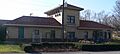
Former Mackinaw train depot
-
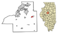
Location of Mackinaw in Tazewell County, Illinois.
-
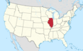
Location of Illinois in the United States
See also
 In Spanish: Mackinaw (Illinois) para niños
