Kennedy, Queensland facts for kids
Quick facts for kids KennedyQueensland |
|||||||||||||||
|---|---|---|---|---|---|---|---|---|---|---|---|---|---|---|---|

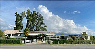
Kennedy State School, 2023
|
|||||||||||||||
| Population | 136 (2021 census) | ||||||||||||||
| • Density | 1.365/km2 (3.54/sq mi) | ||||||||||||||
| Postcode(s) | 4816 | ||||||||||||||
| Elevation | 0–710 m (0–2,329 ft) | ||||||||||||||
| Area | 99.6 km2 (38.5 sq mi) | ||||||||||||||
| Time zone | AEST (UTC+10:00) | ||||||||||||||
| Location |
|
||||||||||||||
| LGA(s) | Cassowary Coast Region | ||||||||||||||
| State electorate(s) | Hinchinbrook | ||||||||||||||
| Federal Division(s) | Kennedy | ||||||||||||||
|
|||||||||||||||
Kennedy is a small coastal area in Queensland, Australia. It's part of the Cassowary Coast Region. In 2021, about 136 people lived here.
Contents
Exploring Kennedy's Geography
Kennedy is right on the coast, with the beautiful Coral Sea forming its eastern edge. This means you can find lovely beaches and ocean views here!
Roads and Railways
The main road, the Bruce Highway, runs through Kennedy from south to north. The North Coast railway line also passes through, just west of the highway. There is a train station called Kennedy railway station. Another old station, Dallachy railway station, is no longer used.
Land and Nature
The land near the coast is mostly flat, close to sea level. But as you go towards the north-west, it gets higher, reaching up to 710 meters (about 2,329 feet) in the foothills of Mount Carruchan.
A big part of Kennedy is covered by nature. The eastern coastal area and the north-west are part of the Girramay National Park. Other western areas belong to the Cardwell State Forest. These parks protect important plants and animals.
Farming and Air Travel
Besides the natural parks, some land in Kennedy is used for farming. Farmers grow crops like sugarcane and also raise animals.
There's also a small airport called Dallarchy Aerodrome. It has a 1-kilometer (about 0.6-mile) grass runway. This aerodrome helps people travel to and from the nearby town of Cardwell.
Kennedy's Past
Kennedy has an interesting history, especially how it got its name!
How Kennedy Got Its Name
The area was named after the Kennedy railway station. This station was first called Mulgan railway station. But on February 20, 1926, it was renamed after a famous explorer named Edmund Kennedy.
School Days in Kennedy
The first school in the area was Kennedy Creek Provisional School. It opened a long time ago, on March 14, 1927. Later, on November 1, 1944, it became Kennedy Creek State School. Finally, on February 19, 1945, it was given its current name: Kennedy State School.
People Living in Kennedy
The number of people living in Kennedy has changed over the years.
- In 2006, about 312 people lived in Kennedy.
- By 2016, the population was around 161 people.
- In the most recent count in 2021, Kennedy had a population of 136 people.
Learning in Kennedy
Kennedy State School is the main school in the area.
Kennedy State School
Kennedy State School is a government primary school. It teaches students from Prep (the first year of school) up to Year 6. It's located at 161 Kennedy Creek Road. In 2017, the school had 21 students and a team of teachers and staff helping them learn.
High School Options
There isn't a high school right in Kennedy. Students who want to go to secondary school usually travel to Tully State High School in the town of Tully, which is north of Kennedy.
 | Percy Lavon Julian |
 | Katherine Johnson |
 | George Washington Carver |
 | Annie Easley |


