Kenwood, California facts for kids
Quick facts for kids
Kenwood
|
|
|---|---|
| Country | |
| State | |
| County | Sonoma |
| Area | |
| • Total | 5.163 sq mi (13.371 km2) |
| • Land | 5.163 sq mi (13.371 km2) |
| • Water | 0 sq mi (0 km2) 0% |
| Elevation | 423 ft (129 m) |
| Population
(2010)
|
|
| • Total | 1,028 |
| • Density | 199.11/sq mi (76.88/km2) |
| Time zone | UTC-8 (PST) |
| • Summer (DST) | UTC-7 (PDT) |
| ZIP codes |
95409/95452
|
| Area code(s) | 707 |
| FIPS code | 06-38156 |
| GNIS feature ID | 226527 |
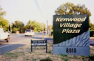
Kenwood is a small, friendly community in Sonoma County, California. It's located along Sonoma Highway, nestled between the bigger cities of Santa Rosa and Sonoma. Kenwood is in the beautiful Sonoma Valley, often called the "Valley of the Moon."
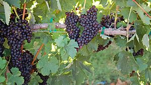
This area is known for its many vineyards and wineries. It's part of California's famous Wine Country. Kenwood also has nice restaurants and a resort. The population of Kenwood was 1,028 people in 2010.
Contents
History of Kenwood
Kenwood is built on land that was once part of a large Mexican land grant called Rancho Los Guilicos. In 1887, a company bought this land. They started planning the town, expecting a railroad to arrive soon.
How Kenwood Got Its Name
The community tried out a few names at first. It was called Rohrerville, then Los Guilicos, and later South Los Guilicos. The South Los Guilicos Depot opened in 1887 when the railroad arrived.
Many people found "Guilicos" hard to say. Around 1895, they voted to change the name again. One story says that "Kenwood" was chosen because many settlers came from Kenwood, Illinois. Another story suggests it was named after London's Kenwood House, as many landowners had English roots. Both stories might be true, showing the name was popular with different groups.
Early Buildings and Landmarks
The First Congregational Church of Los Guilicos was built in 1888. It moved to its current spot in 1893. The church's parsonage (the minister's house) was used as the Kenwood School until a new school was built in 1960. The church is now called Kenwood Community Church and is a historic landmark.
Famous Visitors and Events
Some important people owned ranches in the Kenwood area. One was Thomas Kearns, a powerful businessman and U.S. Senator. It's said that President Theodore Roosevelt visited him at his ranch, also known as the William Hood House.
Kenwood is also famous for starting the World Pillow Fight Championships in the 1970s. Local groups held these fun events to raise money for town improvements. A steel pole was set up over a creek filled with mud, and people would try to knock each other off with pillows! The last championships in Kenwood were in 2006, but they are still held in other parts of the United States.
In 1983, Ray Flugger started Flowmaster, a company that makes car parts, right here in Kenwood from a small barn.
People of Kenwood
| Historical population | |||
|---|---|---|---|
| Census | Pop. | %± | |
| U.S. Decennial Census | |||
In 2010, Kenwood had a population of 1,028 people. Most residents were White (90.5%). There were also smaller numbers of Asian, Native American, African American, and Pacific Islander people. About 7.7% of the population was Hispanic or Latino.
Most people in Kenwood live in family homes. The average household had about two people. Many homes are owned by the people who live in them.
Parks and Outdoor Fun
Kenwood has several parks where you can enjoy the outdoors.
- Kenwood Plaza Park is located on Warm Springs Road.
- Shaw Park is on Shaw Avenue.
Both of these parks are managed by the Sonoma County Regional Parks Department.
There are also several larger parks nearby:
- Annadel State Park is to the west.
- Hood Mountain Regional Park is to the north.
- Sugarloaf Ridge State Park is to the northeast.
- Jack London State Historic Park is a bit further south.
Utilities and Services
Kenwood gets its telephone service from Verizon. The area code for Kenwood is 707. Some parts of a nearby city, Santa Rosa, also use Kenwood's phone prefixes because they are in the same service area.
Geography and Climate
Kenwood covers an area of about 5.2 square miles (13.5 square kilometers), and it's all land.
Kenwood's Climate
Kenwood has a "Mediterranean climate." This means it has warm, dry summers and mild, wet winters. The average temperature in the warmest months is above 50°F (10°C). In the coldest months, the average temperature is between 27°F and 64°F (-3°C and 18°C). Summers usually have very little rain.
| Climate data for Kenwood, CA | |||||||||||||
|---|---|---|---|---|---|---|---|---|---|---|---|---|---|
| Month | Jan | Feb | Mar | Apr | May | Jun | Jul | Aug | Sep | Oct | Nov | Dec | Year |
| Mean daily maximum °C (°F) | 13 (56) |
16 (61) |
18 (65) |
22 (71) |
26 (78) |
29 (85) |
32 (90) |
32 (89) |
29 (85) |
25 (77) |
19 (66) |
14 (57) |
23 (74) |
| Mean daily minimum °C (°F) | 2 (36) |
4 (40) |
4 (40) |
6 (43) |
8 (47) |
10 (50) |
11 (52) |
11 (51) |
9 (49) |
7 (45) |
4 (40) |
3 (37) |
7 (44) |
| Average precipitation mm (inches) | 190 (7.6) |
170 (6.5) |
110 (4.3) |
53 (2.1) |
20 (0.8) |
5.1 (0.2) |
0 (0) |
2.5 (0.1) |
7.6 (0.3) |
43 (1.7) |
99 (3.9) |
180 (6.9) |
880 (34.6) |
| Source: Weatherbase | |||||||||||||
Wineries in Kenwood
Kenwood is famous for its many wineries, where grapes are grown and turned into wine. Here are some of them:
|
|
Notable People from Kenwood
Some well-known people have lived in or had connections to Kenwood:
- Valerie K. Brown: She was a member of the California State Assembly and served on the Sonoma County Board of Supervisors.
- Dan Dion: A photographer and producer known for comedy shows.
- Paul Otellini: A successful businessman.
See also
 In Spanish: Kenwood (California) para niños
 | Emma Amos |
 | Edward Mitchell Bannister |
 | Larry D. Alexander |
 | Ernie Barnes |


