Keysville, Georgia facts for kids
Quick facts for kids
Keysville, Georgia
|
|
|---|---|

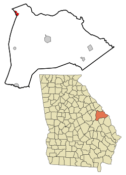
Location in Burke County and the state of Georgia
|
|
| Country | United States |
| State | Georgia |
| Counties | Burke, Jefferson |
| Area | |
| • Total | 1.08 sq mi (2.79 km2) |
| • Land | 1.05 sq mi (2.73 km2) |
| • Water | 0.02 sq mi (0.06 km2) |
| Elevation | 262 ft (80 m) |
| Population
(2020)
|
|
| • Total | 300 |
| • Density | 284.63/sq mi (109.92/km2) |
| Time zone | UTC-5 (Eastern (EST)) |
| • Summer (DST) | UTC-4 (EDT) |
| ZIP codes |
30811, 30816
|
| Area code(s) | 706 |
| FIPS code | 13-43360 |
| GNIS feature ID | 0316404 |
Keysville is a small town located in the state of Georgia, in the United States. It's special because it's in two different counties: Burke County and Jefferson County. In 2020, about 300 people lived there.
Keysville's Story
Keysville officially became a town in 1890. This means the state government, called the Georgia General Assembly, gave it permission to have its own local government.
However, in 1933, the town's government stopped working. Even though it wasn't officially removed, it didn't operate for many years. Then, in the late 1990s, the town's government was started up again.
Where is Keysville?
Keysville is located in Georgia, about 23 miles (37 km) southwest of downtown Augusta. You can find its exact spot using these coordinates: 33°14′7″N 82°13′54″W.
The United States Census Bureau says that Keysville covers a total area of about 1.08 square miles (2.8 square kilometers). A very small part of this area, about 0.02 square miles (0.06 square kilometers), is water.
Who Lives in Keysville?
The number of people living in Keysville has changed over the years. This information comes from the U.S. Census, which counts everyone in the country every ten years. Keysville first appeared in the census in 1930.
| Historical population | |||
|---|---|---|---|
| Census | Pop. | %± | |
| 1930 | 378 | — | |
| 1940 | 363 | −4.0% | |
| 1950 | 304 | −16.3% | |
| 1990 | 350 | — | |
| 2000 | 180 | −48.6% | |
| 2010 | 332 | 84.4% | |
| 2020 | 300 | −9.6% | |
| U.S. Decennial Census 1850-1870 1880 1890-1910 1920-1930 1930-1940 1940-1950 1960-19801980-2000 |
|||
Keysville was not listed in the census reports for 1960, 1970, or 1980. It reappeared in the 1990 census.
Population Details
The table below shows the different groups of people who live in Keysville. The census looks at different races and also at people who are Hispanic or Latino. People who are Hispanic or Latino can be of any race.
| Race / Ethnicity (NH = Non-Hispanic) | Pop 2000 | Pop 2010 | Pop 2020 | % 2000 | % 2010 | % 2020 |
|---|---|---|---|---|---|---|
| White alone (NH) | 60 | 125 | 91 | 33.33% | 37.65% | 30.33% |
| Black or African American alone (NH) | 112 | 183 | 185 | 62.22% | 55.12% | 61.67% |
| Native American or Alaska Native alone (NH) | 0 | 0 | 0 | 0.00% | 0.00% | 0.00% |
| Asian alone (NH) | 0 | 6 | 4 | 0.00% | 1.81% | 1.33% |
| Pacific Islander alone (NH) | 0 | 0 | 0 | 0.00% | 0.00% | 0.00% |
| Some Other Race alone (NH) | 1 | 0 | 0 | 0.56% | 0.00% | 0.00% |
| Mixed Race or Multi-Racial (NH) | 4 | 6 | 11 | 2.22% | 1.81% | 3.67% |
| Hispanic or Latino (any race) | 3 | 12 | 9 | 1.67% | 3.61% | 3.00% |
| Total | 180 | 332 | 300 | 100.00% | 100.00% | 100.00% |
In 2020, the total population of Keysville was 300 people.
See also
 In Spanish: Keysville (Georgia) para niños
 | Dorothy Vaughan |
 | Charles Henry Turner |
 | Hildrus Poindexter |
 | Henry Cecil McBay |

