Killegray facts for kids
| Gaelic name | Ceileagraigh |
|---|---|
| Norse name | kjallard-øy |
| Meaning of name | Old Norse: graveyard island |
| OS grid reference | NF976836 |
| Coordinates | 57°44′N 7°05′W / 57.74°N 7.08°W |
| Physical geography | |
| Island group | Outer Hebrides |
| Area | 176 ha (11⁄16 sq mi) |
| Area rank | 117 |
| Highest elevation | 45 m (148 ft) |
| Administration | |
| Sovereign state | United Kingdom |
| Country | Scotland |
| Council area | Comhairle nan Eilean Siar |
| Demographics | |
| Population | 0 |
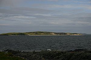
Killegray is a small island located in the Sound of Harris, a channel of water in the Outer Hebrides of Scotland. It's a quiet, uninhabited place with a rich history and interesting wildlife.
About Killegray's Land

Killegray is found in the Sound of Harris, which is a stretch of water between North Uist and the Isle of Harris. The island is about 1.5 miles (2.4 km) long.
The southern part of the island has a lot of deep, boggy land. However, the northern part of Killegray has more fertile land, which is better for growing things.
A Look at Killegray's History
In the north of Killegray, there are the ruins of an old chapel called Teampull na h-Annait. This chapel might be where the island got its name.
Killegray is currently uninhabited, meaning no one lives there permanently. But a family of three to five people lived on the island from 1861 to 1931. Also, two people were briefly living there when a count was taken in 1971.
The only house on the island, Killegray House, was built in the 1800s. It was fixed up in 1991 to be used for holidays.
Animals of Killegray
The shallow waters and reefs around Killegray are a great place for velvet crabs and lobsters to live and have their babies. These waters provide a rich environment for them to grow.
See also
In Spanish: Killegray para niños
 | Sharif Bey |
 | Hale Woodruff |
 | Richmond Barthé |
 | Purvis Young |

