Sound of Harris facts for kids
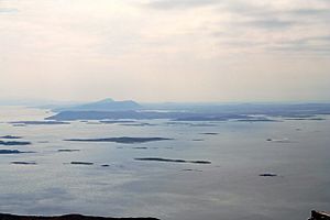
The Sound of Harris (which is Caolas na Hearadh in Scottish Gaelic) is a watery channel. It lies between two islands: Harris and North Uist. Both of these islands are part of the Outer Hebrides in Scotland.
Contents
What is the Sound of Harris?
The Sound of Harris is like a natural highway across the sea. It is about 8 miles (13 kilometers) wide. This channel is a very important sea route through the Hebrides islands. Ships use it to travel from the big Atlantic Ocean to a smaller sea area called The Minch.
Islands and Reefs in the Sound
Many islands and underwater rocks, called reefs, are found in the Sound of Harris. Some of the biggest islands here include Berneray, Pabbay, Ensay, and Killegray. These islands make the journey through the Sound interesting and sometimes tricky for boats.
A Special Natural Area
The Sound of Harris is part of a special place called the South Lewis, Harris and North Uist National Scenic Area. Scotland has 40 of these areas. They are protected because of their amazing natural beauty and landscapes.
How Do People Cross the Sound?
A vehicle ferry helps people and cars cross the Sound of Harris. This ferry service started in 1996.
The Ferry Route
The ferry connects Leverburgh on the island of Harris to Berneray. Berneray is then linked to North Uist by a special road built over the water, called a causeway. Before this causeway opened, the ferry used to land at a place called Otternish.
Who Operates the Ferry?
The ferry service is run by a company called Caledonian MacBrayne. At first, a ferry named MV Loch Bhrusda was used until 2003. Then, a much larger ferry, the MV Loch Portain, took over.
Keeping the Ferry Safe
There is a marked path in the water with special buoys (floating markers). These buoys help guide the ferry safely. The Maritime and Coastguard Agency (MCA) has a rule: the ferry can only move forward if the crew can see the next two marker buoys. This rule helps keep everyone safe during the journey.
 | Kyle Baker |
 | Joseph Yoakum |
 | Laura Wheeler Waring |
 | Henry Ossawa Tanner |


