South Lewis, Harris and North Uist National Scenic Area facts for kids
Quick facts for kids South Lewis, Harris and North Uist National Scenic Area |
|
|---|---|

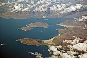
West Loch Tarbert and Taransay
|
|

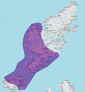
The location of the NSA within the northern Outer Hebrides.
|
|
| Location | Western Isles, Scotland |
| Area | 2,024 km2 (781 sq mi) |
| Established | 1981 |
| Governing body | NatureScot |
The South Lewis, Harris and North Uist area is a huge, beautiful place in the Western Isles of Scotland. It's known as a National Scenic Area (NSA). Scotland has 40 of these special areas. They are chosen because they have amazing views and landscapes. This helps protect them from building projects that might spoil their natural beauty.
This NSA is the largest in Scotland. It covers about 202,388 hectares in total. A hectare is about the size of a sports field. Over half of this area (112,301 hectares) is land. The rest (90,087 hectares) is ocean, including areas below the low tide mark. The protected land includes the mountains in the southwest of the Isle of Lewis. It also covers all of Harris, the Sound of Harris, and the northern part of North Uist.
While NSAs are mainly about protecting beautiful scenery, they often have other cool features. These can include important cultural sites, historical places, old archaeological finds, interesting geology, or special wildlife. Many of these areas are also protected by other national and international rules. For example, there are several Natura 2000 sites within this NSA.
Even though being an NSA helps protect the land, there isn't a special "park authority" like you'd find in a national park. Instead, the local council, Comhairle nan Eilean Siar, helps manage the area. They can create plans to look after the NSA.
Contents
Why Was This Area Protected?
After the Second World War, people in Scotland wanted to protect their beautiful landscapes. A group was set up in 1945 to figure out how to do this. They suggested that five areas should get special protection. These included places like Loch Lomond and the Cairngorms. The government called these "national park direction areas." This meant the government could check any building plans in these places.
Later, in 1978, another review looked at protecting more landscapes. The area of South Lewis, Harris and North Uist was identified as a place with amazing scenery that needed protection. So, in 1981, the old "direction areas" were replaced by the new National Scenic Area (NSA) title. This new plan included the South Lewis, Harris and North Uist area.
The boundaries of this NSA are still the same as they were in 1978. The area was officially re-designated under new laws in 2010. Some people have asked for even more protection, like making Harris a national park. However, the Scottish Government decided in 2011 not to create new national parks. They wanted to focus on the two national parks Scotland already has.
What Does the South Lewis, Harris and North Uist NSA Look Like?
This NSA is full of diverse and stunning landscapes.
The Mountains of North Harris
In North Harris, you'll find Clisham. At 799 meters, it's the highest mountain in the Outer Hebrides. This area has steep valleys and tall, rocky cliffs. It feels very wild and mountainous. Strong winds and grazing animals mean that not many trees grow here. Deep sea lochs, which are like long, narrow inlets of the sea, cut far into the hills on the east side.
Harris Coasts and Beaches
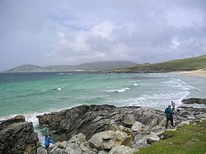
The east coast of Harris has many small bays and islands. The west coast is very different. It has wide, sandy beaches. These beaches are often backed by a unique grassy area called machair. Rocky headlands stick out into the sea, separating the bays. Over time, the ocean has carved these rocks into interesting shapes like geos (narrow inlets) and stacks (tall rock columns).
The Sound of Harris and North Uist
Scattered islands lie in the Sound of Harris. This is the stretch of water between South Harris and North Uist.
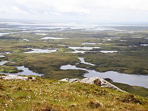
On North Uist, there are amazing deep peatlands. These wet, boggy areas support many different plants and birds. The town of Lochmaddy is on North Uist. Its name comes from the Scottish Gaelic Loch nam Madadh. Lochmaddy is a busy place where ferries arrive and depart. It's also a harbor for creel fishing boats and has salmon farms.
Protecting Wildlife and Habitats
The South Lewis, Harris and North Uist NSA has many important conservation areas. These include four Special Protection Areas (SPAs) and five Special Areas of Conservation (SACs). These are part of the Natura 2000 network, which protects important natural sites across Europe. Some areas have both SPA and SAC protection.
Grimersta River and Lewis Peatlands
The Grimersta river and loch system in south Lewis is very special. It's considered the best place for Atlantic salmon in the Western Isles and is protected as an SAC. The surrounding peatlands of Lewis are an SPA. This means they are important for breeding birds like black-throated divers, dunlins, golden eagles, golden plovers, greenshank, merlin, and red-throated divers.
North Harris Habitats
Much of North Harris is protected as an SAC. This is because it has a wide variety of mountain and heathland habitats. It's also an SPA, important for its breeding golden eagles.
North Uist Machair
The machair on North Uist is the second-largest area of machair in the Western Isles. It's unique because much of it has been traditionally farmed or used for grazing animals. This creates a different ecosystem compared to machair further south. It's protected as both an SAC and an SPA. The SPA also includes parts of nearby islands like Berneray, Pabbay, and Boreray.
Loch nam Madadh
Loch nam Madadh is a very special sea loch. It's a unique type of fjord-like loch that mixes salt and fresh water. This creates an unusual environment for plants and animals that live between the tides. It's protected as an SAC. In some parts, freshwater creatures can even live in a layer just above saltwater creatures.
Mointeach Scadabhaigh Blanket Bog
Mointeach Scadabhaigh is a large area of blanket bog in South Uist. It's the biggest example in the UK of a rare type of blanket bog. It's also home to many breeding red-throated divers and black-throated divers. This area has one of the highest numbers of red-throated divers in the UK. It is protected as both an SAC and an SPA.
 | Jessica Watkins |
 | Robert Henry Lawrence Jr. |
 | Mae Jemison |
 | Sian Proctor |
 | Guion Bluford |


