Kissee Mills, Missouri facts for kids
Quick facts for kids
Kissee Mills, Missouri
|
|
|---|---|

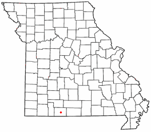
Location of Kissee Mills in Missouri
|
|
| Country | United States |
| State | Missouri |
| County | Taney |
| Area | |
| • Total | 9.34 sq mi (24.18 km2) |
| • Land | 8.80 sq mi (22.78 km2) |
| • Water | 0.54 sq mi (1.40 km2) |
| Elevation | 945 ft (288 m) |
| Population
(2020)
|
|
| • Total | 1,023 |
| • Density | 116.30/sq mi (44.90/km2) |
| ZIP code |
65680
|
| Area code(s) | 417 |
| FIPS code | 29-39080 |
| GNIS feature ID | 2587084 |
Kissee Mills (pronounced "Kiz-zē' Mills") is a small community in Taney County, Missouri, United States. It's known as a census-designated place. This means it's an area that looks like a town but isn't officially a city or village. It's located on U.S. Route 160, about five miles east of Forsyth. Kissee Mills is also part of the larger Branson, Missouri area.
History of Kissee Mills
Kissee Mills got its name from a man named A. C. Kissee. He owned a local watermill in the area. A watermill uses the power of flowing water to grind grain or do other work. The community has had a post office since 1871. This shows that people have lived and worked in Kissee Mills for a long time.
Population and People
In 2020, the population of Kissee Mills was 1,023 people. This number comes from the 2020 United States Census. A census is like a big count of all the people living in a place. It helps us understand how communities are growing or changing.
See also
 In Spanish: Kissee Mills (Misuri) para niños
 | Selma Burke |
 | Pauline Powell Burns |
 | Frederick J. Brown |
 | Robert Blackburn |

