Koosharem, Utah facts for kids
Quick facts for kids
Koosharem, Utah
|
|
|---|---|

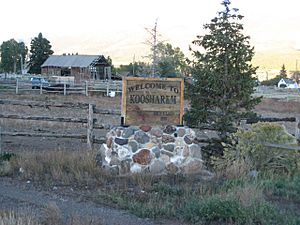
Welcome sign in Koosharem, September 2007
|
|

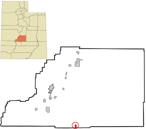
Location in Sevier County and the state of Utah.
|
|
| Country | United States |
| State | Utah |
| County | Sevier |
| Settled | 1877 |
| Named for | Native American word for the valley named after the deep red clover indigenous to the area. |
| Area | |
| • Total | 0.83 sq mi (2.16 km2) |
| • Land | 0.83 sq mi (2.16 km2) |
| • Water | 0.00 sq mi (0.00 km2) |
| Elevation | 6,919 ft (2,109 m) |
| Population
(2010)
|
|
| • Total | 327 |
| • Estimate
(2019)
|
330 |
| • Density | 396.16/sq mi (152.96/km2) |
| Time zone | UTC-7 (Mountain (MST)) |
| • Summer (DST) | UTC-6 (MDT) |
| ZIP code |
84744
|
| Area code(s) | 435 |
| FIPS code | 49-41680 |
| GNIS feature ID | 1442357 |
Koosharem is a small town located in Sevier County, Utah, United States. It is also known as "Grass Valley." This area includes Burrville to the north and Greenwich to the south. The valley is surrounded by private lands within the beautiful Fishlake National Forest.
Koosharem is a convenient stop for travelers. It sits at a crossroads for those visiting famous national parks like Capitol Reef National Park, Bryce Canyon National Park, and Zion National Park. It's also the closest town to the well-known Fish Lake. The town is an important spot along the many trails of the Piute ATV Trail System, which is popular for off-road adventures.
The name Koosharem comes from the Paiute people, who are Native Americans from this area. They named the valley after the deep red clover that grows in its green meadows. In 2000, the town had a population of 276 people.
Contents
According to the United States Census Bureau, Koosharem covers about 0.6 square miles (1.5 square kilometers) of land. In 2008, the town grew a bit, and its population was estimated to be around 400 people.
Even though Koosharem is a small and quiet town, it has several important places. These include a church, a cemetery, a baseball field, and a fire station. There's also a dairy farm, a motel for visitors, two restaurants, and a general store that also has the post office inside.
Koosharem is in a rural area, meaning it's surrounded by nature and not big cities. However, it's fairly central to many interesting spots in Utah and beyond. Here's how far Koosharem is from some popular destinations:
| Destination | Road Miles |
|---|---|
| Bryce Canyon National Park | 70 |
| Fish Lake, Sevier County | 15 |
| Zion National Park | 133 |
| Richfield, Utah | 29 |
| Sigurd, Utah | 28 |
| Salt Lake City, Utah (Airport) | 185 |
| Las Vegas, Nevada (Airport) | 292 |
| Moab, Utah | 195 |
| Grand Junction, Colorado | 244 |
Local Wildlife and Nature
The Koosharem area and Grass Valley are home to many different animals, including some that are rare or protected. These include the Greater sage-grouse, the Utah prairie dog, and the Pygmy Rabbit. You might also spot large birds like bald eagles, golden eagles, and ferruginous hawks. Even small creatures like western toads live here.
Koosharem has a cold semi-arid climate. This means it's generally dry, but it can get quite cold, especially in winter.
| Climate data for Koosharem, Utah, 1991–2020 normals, 1893-2020 extremes: 6930ft (2112m) | |||||||||||||
|---|---|---|---|---|---|---|---|---|---|---|---|---|---|
| Month | Jan | Feb | Mar | Apr | May | Jun | Jul | Aug | Sep | Oct | Nov | Dec | Year |
| Record high °F (°C) | 64 (18) |
69 (21) |
77 (25) |
79 (26) |
91 (33) |
96 (36) |
98 (37) |
98 (37) |
92 (33) |
90 (32) |
78 (26) |
63 (17) |
98 (37) |
| Mean maximum °F (°C) | 51.8 (11.0) |
55.5 (13.1) |
65.1 (18.4) |
72.9 (22.7) |
81.8 (27.7) |
87.6 (30.9) |
92.4 (33.6) |
89.1 (31.7) |
83.8 (28.8) |
77.5 (25.3) |
64.4 (18.0) |
54.4 (12.4) |
91.3 (32.9) |
| Mean daily maximum °F (°C) | 38.7 (3.7) |
43.0 (6.1) |
51.7 (10.9) |
59.1 (15.1) |
68.6 (20.3) |
79.6 (26.4) |
84.9 (29.4) |
81.8 (27.7) |
74.8 (23.8) |
62.5 (16.9) |
50.7 (10.4) |
39.4 (4.1) |
61.2 (16.2) |
| Daily mean °F (°C) | 25.3 (−3.7) |
29.3 (−1.5) |
36.5 (2.5) |
42.9 (6.1) |
50.5 (10.3) |
60.3 (15.7) |
66.4 (19.1) |
64.2 (17.9) |
56.9 (13.8) |
45.3 (7.4) |
34.8 (1.6) |
25.0 (−3.9) |
44.8 (7.1) |
| Mean daily minimum °F (°C) | 11.9 (−11.2) |
15.6 (−9.1) |
21.4 (−5.9) |
26.7 (−2.9) |
32.4 (0.2) |
41.1 (5.1) |
47.9 (8.8) |
46.6 (8.1) |
39.0 (3.9) |
28.2 (−2.1) |
18.9 (−7.3) |
10.7 (−11.8) |
28.4 (−2.0) |
| Mean minimum °F (°C) | −9.1 (−22.8) |
−1.5 (−18.6) |
5.7 (−14.6) |
14.3 (−9.8) |
21.4 (−5.9) |
29.4 (−1.4) |
37.4 (3.0) |
37.3 (2.9) |
25.4 (−3.7) |
14.9 (−9.5) |
2.0 (−16.7) |
−7.0 (−21.7) |
−11.6 (−24.2) |
| Record low °F (°C) | −28 (−33) |
−24 (−31) |
−13 (−25) |
0 (−18) |
12 (−11) |
18 (−8) |
27 (−3) |
26 (−3) |
11 (−12) |
−6 (−21) |
−17 (−27) |
−32 (−36) |
−32 (−36) |
| Average precipitation inches (mm) | 0.70 (18) |
0.48 (12) |
0.72 (18) |
0.59 (15) |
0.88 (22) |
0.55 (14) |
1.29 (33) |
1.37 (35) |
1.14 (29) |
1.16 (29) |
0.56 (14) |
0.65 (17) |
10.09 (256) |
| Average snowfall inches (cm) | 7.30 (18.5) |
5.90 (15.0) |
6.40 (16.3) |
2.20 (5.6) |
1.00 (2.5) |
0.20 (0.51) |
0.00 (0.00) |
0.00 (0.00) |
0.10 (0.25) |
1.90 (4.8) |
4.80 (12.2) |
8.30 (21.1) |
38.1 (96.76) |
| Source 1: NOAA (1981-2010 snowfall) | |||||||||||||
| Source 2: XMACIS2 (records & monthly max/mins) | |||||||||||||
Koosharem's economy relies on two main things: traditional farming and a growing number of businesses that serve tourists.
Farming and Ranching
Farming and raising livestock (like cows) are still very important jobs here. People use the land to grow crops and raise animals, which has been a part of Koosharem for a long time.
Tourism and Fun Activities
Because Koosharem is close to so many natural attractions, tourism is becoming a big part of its economy.
- The Fishlake National Forest and the Piute ATV Trail bring in many people who love the outdoors.
- Being near national parks means lots of visitors come through the town.
- The area is famous for hunting, especially for elk. In 2008, a world-record elk called the "Spider Bull" was found near Koosharem.
- Some local businesses rent out ATVs (all-terrain vehicles) so people can explore the trails.
Local Businesses
In the center of town, you'll find:
- The Koosharem Mercantile, often called "the Merc." This is a general store that acts as a meeting place for the community.
- Two restaurants: the Red Clover Cafe and the Koosharem Cafe.
Other Ways People Make a Living
- Sorenson's Ranch School, a school for troubled youth, provides jobs for many people.
- There are also guides who help hunters and tourists explore the area.
Koosharem's economy is always changing. It keeps its farming roots while also growing its services for both people who live there and those who visit.
| Historical population | |||
|---|---|---|---|
| Census | Pop. | %± | |
| 1890 | 232 | — | |
| 1900 | 400 | 72.4% | |
| 1910 | 287 | −28.2% | |
| 1920 | 373 | 30.0% | |
| 1930 | 319 | −14.5% | |
| 1940 | 375 | 17.6% | |
| 1950 | 300 | −20.0% | |
| 1960 | 148 | −50.7% | |
| 1970 | 141 | −4.7% | |
| 1980 | 183 | 29.8% | |
| 1990 | 266 | 45.4% | |
| 2000 | 276 | 3.8% | |
| 2010 | 327 | 18.5% | |
| 2019 (est.) | 330 | 0.9% | |
| U.S. Decennial Census | |||
In 2010, the town of Koosharem had 327 residents. This was an 18.48% increase from the year 2000. In 2000, there were 276 people living in 88 households, with 79 of those being families. The population density was about 497 people per square mile.
Most of the people in Koosharem are White (94.93%). There are also smaller numbers of Native American, Asian, and Pacific Islander residents. About 4.71% of the population identified as Hispanic or Latino.
In 2000, many households (46.6%) had children under 18 living with them. Most households (80.7%) were married couples. The average household had about 3.14 people, and the average family had about 3.30 people.
The population of Koosharem is spread out across different age groups. About 35.1% of residents are under 18 years old. The median age in 2000 was 30 years old. This means half the people were younger than 30 and half were older.
The median income for a household in Koosharem was $34,583. For families, the median income was $40,625. About 8.8% of the total population lived below the poverty line.
Koosharem is part of the Sevier School District.
Elementary School
- Koosharem Elementary School teaches the younger students in the town.
Secondary Education (Junior High and High School)
- Koosharem does not have its own junior high or high school.
- Students go to school in nearby towns. They can attend either:
- Piute High School in Junction, Utah; or
- Richfield High School in Richfield, Utah.
School Transportation
- School buses pick up Koosharem students and take them to both Junction and Richfield every day.
Images for kids
See also
 In Spanish: Koosharem (Utah) para niños
 | William Lucy |
 | Charles Hayes |
 | Cleveland Robinson |

