La Amelia facts for kids
| Location | Sayaxché |
|---|---|
| Region | Petén Department, |
| Coordinates | 16°31′35″N 90°25′22″W / 16.52639°N 90.42278°W |
| History | |
| Abandoned | mid-9th century AD |
| Periods | Late Classic |
| Cultures | Maya |
| Events | Conquered by: Dos Pilas |
| Site notes | |
| Excavation dates | 1937, 1984–1986, 1997 |
| Archaeologists | Edwin Shook, Antonia Foias |
| Architecture | |
| Architectural styles | Classic Maya |
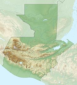
La Amelia is an ancient Maya archaeological site. It is located in the Petén Department of Guatemala, near the Pasión River. This site was an important Maya city during the Late Classic period, from about AD 600 to 830.
La Amelia was part of a larger kingdom and was involved in wars between powerful Maya cities like Tikal and Calakmul. Around AD 650, it was taken over by the city of Dos Pilas. After about two centuries of occasional fighting, the number of people in the area became very small. This led to the abandonment of many Classic Maya sites in the region around AD 830.
Contents
Where is La Amelia?
La Amelia is found on some low hills in the Sayaxché area of Guatemala. It is about 4 kilometers (2.5 miles) south of the village of La Florida and the Pasión River. The site sits at a height of about 150 to 160 meters (490 to 525 feet) above sea level. The lower areas around the hills can sometimes flood.
The main part of the site is now a forest park, cared for by the nearby village of San Francisco El Tumbo. Sadly, more than 90 percent of the ancient mounds at the site have been damaged by people looking for treasures.
History of La Amelia
La Amelia was a smaller city within the Petexbatún kingdom during the Classic Period. This kingdom was first ruled from Dos Pilas and later from Aguateca. La Amelia is located to the northwest of Dos Pilas. It might have originally been called B'ahlam. The Dos Pilas kingdom was growing quickly and conquered La Amelia in the early 8th century. It seems La Amelia was only lived in for a short time, mainly during the Late Classic period.
In AD 802, the last known ruler of the kingdom, Tan Te' K'inich, oversaw a special event. This event was led by the ruler of La Amelia, named Lachan K'awiil Ajaw Bot. This is the last time Tan Te' K'inich is mentioned anywhere. Lachan K'awiil Ajaw Bot, the local king of La Amelia, is shown on a stone carving called La Amelia Panel 2, which is dated to AD 804. He continued to set up monuments at the site. The last one that can be dated was put up in 807. This monument also contains the last mention of the Petexbatún kingdom.
Lachan K'awiil Ajaw Bot is also mentioned on Panel 1 and Hieroglyphic Stairway 1 at the site. We know he was born on June 25, 760, and became king on May 1, 802. La Amelia was abandoned sometime in the middle of the 9th century AD.
Modern Discoveries
The Carnegie Institution started exploring the site in 1937. They found several carved stone monuments and made a partial map of the site. This map was later published by Sylvanus Morley in 1938. Yale University continued these explorations from 1984 to 1986.
In 1997, the La Amelia Archaeological Project carried out a new mapping and digging project. This work was led by Dr. Antonia Foias from Williams College. During that summer, the project finished mapping the central area of the site and dug several test pits.
What the Site Looks Like
La Amelia is a small site, covering an area of about 0.74 square kilometers (0.29 square miles). The site is divided into four main groups. Two of these groups have large, important buildings. There are also 13 smaller groups where people likely lived. The 1997 mapping project recorded a total of 71 structures at the site.
The main plaza area seems to have been centered around the "Group of the Three Pyramids" in the southern part of the site. This group included three pyramids, ranging from 3 to 8 meters (10 to 26 feet) tall. All of them have been badly damaged by looters.
The "Group of the Hieroglyphic Stairway" is about 0.5 kilometers (0.3 miles) north of the main plaza. It was built mainly by making flat terraces on top of a natural hill. This group has three terraces at the front and a courtyard on the hilltop. This courtyard is surrounded by six narrow buildings. You could reach the lowest terrace by a 5-step stone stairway. These steps were made of limestone blocks carved with pictures and hieroglyphs (ancient writings). Two carved panels, called Stela 1 and Panel 2, originally decorated the front of the structure, on either side of the stairway.
Important Monuments
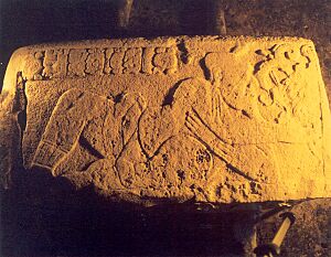
When Edwin M. Shook first explored La Amelia in 1937, he found six blocks with hieroglyphs. These blocks were used as risers (the vertical part of a step) on the top level of the stone stairway. This led him to identify the Hieroglyphic Stairway at the site and name the group of buildings after it. A seventh carved block was found in 1997 during digging near the staircase.
Three of the carved stones from the Hieroglyphic Stairway had only hieroglyphs. The other four stones (including the one found in 1997) showed reclining male figures along with short texts. Stephen Houston studied one of the three glyphic stones, but we don't have records of the other two. Shook sketched the three steps he saw that showed human figures, but he did not include details about the hieroglyphic texts on them. None of the six steps recorded by Shook were still in their original place by 1997, and we don't know where they are now.
The four carved steps from the Hieroglyphic Stairway that show human figures all display images of men dressed simply. These figures were likely ancestors of the site's ruler. All four of these figures are holding heads or masks of God K, a Maya deity. The panel discovered in 1997 included a Calendar Round date of 2 Caban 2 Muan. It also had a text describing a ritual involving God K that happened on that date. The symbol for the figure on this panel might be that of Tamarindito, another Maya site.
The carved panels that originally stood next to the Hieroglyphic Stairway at La Amelia show dancing rulers in full ceremonial clothing, along with hieroglyphic texts. A lower part of each monument shows a reclining jaguar looking up at the dancing ruler. Panel 2 records a date of AD 804 and shows the ruler Lachan K'awiil Ajaw Bot dressed as a ballplayer. Panel 2 is now in front of the Mayor's building in Sayaxché. Stela 1 was originally located west of the Hieroglyphic Stairway and records a date of AD 807. Stela 1 is now at the National Museum of Anthropology and Ethnology in Guatemala City.
See also
 In Spanish: La Amelia (sitio arqueológico) para niños
 | Isaac Myers |
 | D. Hamilton Jackson |
 | A. Philip Randolph |


