La Fuente de San Esteban facts for kids
Quick facts for kids
La Fuente de San Esteban
|
|||
|---|---|---|---|

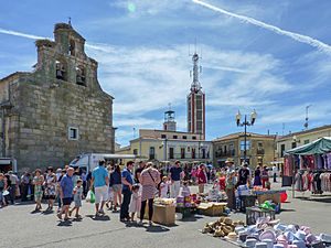
Town square
|
|||
|
|||

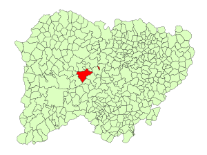
Location in Salamanca
|
|||
| Country | Spain | ||
| Autonomous community | Castile and León | ||
| Province | Salamanca | ||
| Comarca | Comarca de Ciudad Rodrigo | ||
| Subcomarca | Campo del Yeltes | ||
| Area | |||
| • Total | 77 km2 (30 sq mi) | ||
| Elevation | 770 m (2,530 ft) | ||
| Population
(2018)
|
|||
| • Total | 1,336 | ||
| • Density | 17.35/km2 (44.94/sq mi) | ||
| Time zone | UTC+1 (CET) | ||
| • Summer (DST) | UTC+2 (CEST) | ||
| Postal code |
37200
|
||
La Fuente de San Esteban is a charming village and a larger area called a municipality. It is located in the western part of Spain, within the province of Salamanca. This area is part of the Castile-Leon region.
The village is about 54 kilometers (34 miles) away from Salamanca, which is the main city of the province. Around 1,358 people live in La Fuente de San Esteban.
Long ago, the town had a direct train line that connected it to Porto in Portugal. This was part of the Douro railway line. However, the section of the railway line that went from La Fuente de San Esteban to the border with Portugal was closed in 1984.
Geography of La Fuente de San Esteban
This municipality covers an area of about 77 square kilometers (30 square miles). It sits 770 meters (2,526 feet) above sea level. The postal code for the area is 37200.
Neighboring Villages
The municipality of La Fuente de San Esteban includes a few smaller villages. These are Boadilla, which has about 197 residents, Muñoz with 99 residents, and Santa Olalla de Yeltes.
See also
 In Spanish: La Fuente de San Esteban para niños
 | Percy Lavon Julian |
 | Katherine Johnson |
 | George Washington Carver |
 | Annie Easley |


