La Jigua facts for kids
Quick facts for kids
La Jigua
|
|
|---|---|
 |
|
| Country | |
| Department | Copán |
| Established | 13 July 1965 |
| Seat | La Jigua |
| Area | |
| • Total | 114 km2 (44 sq mi) |
| Population
(2013 Census)
|
|
| • Total | 9,288 |
| • Density | 81.5/km2 (211.0/sq mi) |
| Time zone | UTC-6 (Central America) |
| Geocode | 0411 |
| Website | Transparency Portal page |
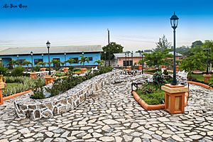
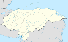
La Jigua is a municipality in western Honduras. It is located in the Copán area. The town is about 30 kilometers (18 miles) north of Santa Rosa de Copán, which is the capital of the department. The name La Jigua comes from an old language called Nahuatl. It means "place that has turquoise."
Contents
Geography of La Jigua
The municipality of La Jigua is located in the valley of the Chamelecón River. This is where the Chamelecón River meets the Tepemechín River. La Jigua shares borders with other towns. To the west and north, it borders Florida. To the east, it borders Nueva Arcadia, and to the south, San Nicolás. The total area of the municipality is 114 square kilometers (44 square miles).
Landscape and Climate
The land in La Jigua is a mix of different types. You can find areas with grass for animals (pastureland) and fields for growing crops (farmland). There are also forests with pine trees and other types of trees.
La Jigua has a mild climate. The average daily temperatures are usually between 18 and 30 degrees Celsius (64 to 86 degrees Fahrenheit). The air is quite humid, with an average humidity of 80%. The wettest months are September and October, when it rains the most. The driest months are March and April, with very little rain.
History of La Jigua
The name "Santiago de los Caballeros de Xiguat" was used for this area as early as 1729. The name "La Jigua" first appeared in records in 1791.
La Jigua used to be part of the municipality of Florida. This was when Florida was created in 1875. However, on July 13, 1965, La Jigua became its own independent municipality. This means it got its own local government.
People of La Jigua
In the 2013 census, La Jigua had a total population of 9,288 people. There are no large cities or urban areas within the municipality. Most of the people living here are of mixed Spanish and Chʼortiʼ heritage. This mix is often called mestizo.
Culture and Heritage

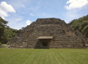
The ancient Mayan archaeological site of El Puente is located in La Jigua. It is found on the Chinamito River, on the north side of the Chamelecón valley. This site became the second archaeological park in Honduras in January 1994. The first was the famous Copán ruins.
The patron saint of La Jigua is Saint James. A patron saint is a special saint who is believed to protect a place or group of people.
Economy and Transportation
Most people in La Jigua work in the primary sector. This means they work directly with natural resources. According to the 2013 census, 69% of the population works in this area. The main crops grown here are corn, beans, and coffee. Raising cattle is also a very important part of the local economy.
Central American Highway 11 passes through La Jigua. This important road connects La Jigua to Copán Ruinas and the border with Guatemala to the west. To the east, it connects to the nearby town of La Entrada. Another road goes north from Highway 11. It passes by the El Puente archaeological site and leads to the village of La Ruidosa.
See also
 In Spanish: La Jigua para niños
 | Stephanie Wilson |
 | Charles Bolden |
 | Ronald McNair |
 | Frederick D. Gregory |


