La Paz Valley, Arizona facts for kids
Quick facts for kids
La Paz Valley, Arizona
|
|
|---|---|
|
Census-designated place (CDP)
|
|

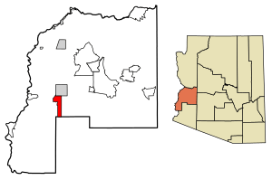
Location of La Paz Valley in La Paz County, Arizona
|
|
| Country | United States |
| State | Arizona |
| County | La Paz |
| Area | |
| • Total | 29.37 sq mi (76.06 km2) |
| • Land | 29.37 sq mi (76.06 km2) |
| • Water | 0.00 sq mi (0.00 km2) |
| Elevation | 1,027 ft (313 m) |
| Population
(2020)
|
|
| • Total | 368 |
| • Density | 12.53/sq mi (4.84/km2) |
| Time zone | UTC-7 (Mountain (MST)) |
| ZIP code |
85346
|
| Area code(s) | 928 |
| GNIS feature ID | 2582813 |
| FIPS code | 04-40160 |
La Paz Valley is a community in La Paz County, Arizona, United States. It's known as a census-designated place (CDP). This means it's a special kind of area that isn't officially a city or town, but the government still counts the people living there for official records.
In 2020, about 368 people lived in La Paz Valley. This community is located in the western part of La Paz County. To the north, it shares a border with the town of Quartzsite. To the south, it borders Yuma County.
Getting Around La Paz Valley
U.S. Route 95 is a major road that forms the eastern edge of La Paz Valley. This highway goes north into Quartzsite and continues south for about 76 miles (122 km) to Yuma.
If you need to get around without a car, the town of Quartzsite offers a bus service called Camel Express. These buses can pick you up and drop you off where you need to go. They provide service to both Quartzsite and La Paz Valley on weekdays.
How Many People Live Here?
The population of La Paz Valley was counted in the 2020 census. At that time, 368 people lived in the area.
| Historical population | |||
|---|---|---|---|
| Census | Pop. | %± | |
| 2020 | 368 | — | |
| U.S. Decennial Census | |||
See also
 In Spanish: La Paz Valley (Arizona) para niños
 | Aurelia Browder |
 | Nannie Helen Burroughs |
 | Michelle Alexander |


