La Plant, South Dakota facts for kids
Quick facts for kids
La Plant, South Dakota
|
|
|---|---|

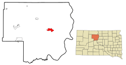
Location in Dewey County and the state of South Dakota
|
|
| Country | United States |
| State | South Dakota |
| County | Dewey |
| Area | |
| • Total | 9.49 sq mi (24.57 km2) |
| • Land | 9.45 sq mi (24.48 km2) |
| • Water | 0.04 sq mi (0.10 km2) |
| Elevation | 2,041 ft (622 m) |
| Population
(2020)
|
|
| • Total | 167 |
| • Density | 17.67/sq mi (6.82/km2) |
| Time zone | UTC-7 (Mountain (MST)) |
| • Summer (DST) | UTC-6 (MDT) |
| ZIP code |
57652
|
| Area code(s) | 605 |
| FIPS code | 46-35940 |
| GNIS feature ID | 2393074 |
La Plant is a small community in Dewey County, South Dakota, United States. It's known as a census-designated place (CDP). In 2020, about 167 people lived there. La Plant is located within the Cheyenne River Indian Reservation.
The community of La Plant was first established in 1910. It was named after a local cattleman who was important to the area.
Exploring La Plant's Location
La Plant is found in the eastern part of Dewey County. A main road, U.S. Route 212, goes right through the community. If you travel west on this road, you'll reach Eagle Butte in about 32 miles. Going east, you'll get to Gettysburg in about 39 miles.
The famous Missouri River (specifically, Lake Oahe) is about 20 miles to the east. Pierre, which is the capital city of South Dakota, is about 76 miles to the southeast.
According to the United States Census Bureau, La Plant covers a total area of about 24.6 square kilometers (or 9.49 square miles). Most of this area is land, with a small part being water.
Who Lives in La Plant?
| Historical population | |||
|---|---|---|---|
| Census | Pop. | %± | |
| 2020 | 167 | — | |
| U.S. Decennial Census | |||
In the year 2000, there were 150 people living in La Plant. All of the residents were Native American.
There were 34 households in the community. Many of these households (58.8%) had children under 18 living with them. The average household had about 4 to 5 people.
The population of La Plant is quite young. In 2000, about 45% of the people were under 18 years old. The median age was 19 years, meaning half the population was younger than 19 and half was older.
Learning in La Plant
Students in La Plant attend schools within the Eagle Butte School District 20-1. This district works together with the Bureau of Indian Education (BIE) to run the Cheyenne-Eagle Butte School.
See also
In Spanish: La Plant (Dakota del Sur) para niños
 | Emma Amos |
 | Edward Mitchell Bannister |
 | Larry D. Alexander |
 | Ernie Barnes |

