
La Soufrière (volcano) facts for kids
Quick facts for kids La Soufrière |
|
|---|---|
| Soufrière Saint Vincent | |
 |
|
| Highest point | |
| Elevation | 1,220 m (4,000 ft) |
| Geography | |
| Location | |
| Geology | |
| Mountain type | Stratovolcano (active) |
| Last eruption | 1979 |
| Climbing | |
| Easiest route | From the Atlantic side |
La Soufrière, also known as Soufrière Saint Vincent, is an active volcano. It is located on the island of Saint Vincent, which is part of the Windward Islands in the Caribbean Sea. Its name, "La Soufrière," means "The Sulfurer" in French, referring to the sulfur gases that often come from volcanoes.
About La Soufrière
La Soufrière is the highest point on the island of Saint Vincent. It stands tall at 1,220 meters (about 4,000 feet) above sea level. It is also the highest point in the entire island country of Saint Vincent and the Grenadines.
This volcano is found in the northern part of Saint Vincent island. It sits between the towns of Wallibou and Chateaubelair to the southwest, and Fancy to the north. To the southeast are Orange Hill and Georgetown.
La Soufrière is a type of volcano called a stratovolcano. This means it is a tall, cone-shaped volcano built up by many layers of hardened lava, ash, and rocks. It has a crater at its top, which holds a lake. This volcano is the youngest and most northern volcano on the island. Its main crater is about 1.6 kilometers (1 mile) wide. A smaller crater formed on its northeast edge in 1812.
Volcanic Eruptions
La Soufrière has erupted many times throughout history. The first recorded eruption happened in 1718. Another big eruption took place in 1812. Both of these caused large explosions.
A very powerful eruption happened in 1902. It devastated much of the northern part of the island. Sadly, this eruption killed 1,680 people. This event happened just hours before another famous volcano, Mount Pelée on Martinique, also erupted.
The most recent eruption of La Soufrière was in April 1979. Luckily, there were no deaths this time. People had enough warning to evacuate safely before the eruption began.
There are several volcanoes in the Caribbean that share a similar name. These include Soufrière Hills on Montserrat and La Grande Soufrière on Guadeloupe. The name "Soufrière" comes from the French word for "sulphur mine," because of the sulfur gases found near these volcanoes.
Images for kids
-
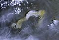
Volcanic plume seen on 9 April 2021 by the Sentinel-3B satellite
_volcanic_ash_-_Sentinel-3.jpg)
See also
 In Spanish: La Soufrière (San Vicente y las Granadinas) para niños
