La Yesa facts for kids
Quick facts for kids
La Yesa
|
||
|---|---|---|
|
Municipality and town
|
||
 |
||
|
||

Municipal location in Valencia
|
||
| Country | ||
| Autonomous community | ||
| Province | Valencia | |
| Comarca | Los Serranos | |
| Judicial district | Llíria | |
| Founded | Independent from 1587 | |
| Area | ||
| • Total | 84.7 km2 (32.7 sq mi) | |
| Elevation | 1,166 m (3,825 ft) | |
| Population
(2018)
|
||
| • Total | 227 | |
| • Density | 2.680/km2 (6.941/sq mi) | |
| Demonym(s) | Yesano/a | |
| Time zone | UTC+1 (CET) | |
| • Summer (DST) | UTC+2 (CEST) | |
| Postal code |
46178
|
|
| Official language(s) | Spanish | |
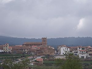
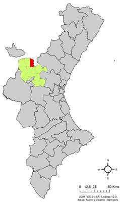
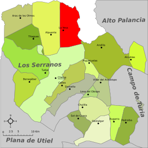
La Yesa is a small town and a type of local government area (called a municipality) in Spain. It's located in the Los Serranos region of the Valencian Community, Spain. Even though it's in the Valencian Community, people in La Yesa mostly speak Spanish, not Valencian.
Contents
Geography of La Yesa
La Yesa covers an area of about 84.7 square kilometers. In 2018, about 227 people lived there. The town is about 21 kilometers north of Chelva and 80 kilometers northwest of Valencia city. You can reach it by roads like CV-35 and CV-345. La Yesa shares a border with Abejuela, a town in the Aragon region, to its northeast.
La Yesa is high up, about 1,166 meters above sea level. This means it has a dry climate with hot summers and cold winters. Temperatures can sometimes drop below freezing (0 °C), and it often snows.
History of La Yesa
People have lived in La Yesa since Roman times. We know this from old objects found there. The area of Alpuente and La Yesa was also important to El Cid, a famous Spanish warrior, who took control of the land in the late 1000s.
During the time of Muslim rule, La Yesa was part of the Taifa Kingdom of Alpuente in the 800s. Later, King James I conquered it in 1236. He then gave it to a person named Juan de Auñón in 1238. In 1583, King Philip II of Spain gave La Yesa the status of a "University," which meant it had certain rights. In 1587, it was officially declared an independent village.
Economy and Local Life
The main ways people make a living in La Yesa are through farming and raising animals. Long ago, in 1611, wheat was an important crop sold in the town.
Today, La Yesa is becoming a popular place for tourists, especially on weekends and holidays. This has helped new shops and bars open up. Mining for a material called kaolin and construction are also important industries in the area. La Yesa has strong connections with the nearby town of Alpuente.
Notable Landmarks and Buildings
La Yesa has several interesting old buildings and places to visit.
Churches and Chapels
The main church is the Iglesia de Nª Sª de los Ángeles. It was finished in 1622 and built in the Renaissance style. It has a square tower. Sadly, the church was burned down in 1840 during the Carlist Wars, but it was rebuilt and finished in 1852. On the left side of the church, there's a strong bell tower made of stone.
There are also several small chapels, called hermitages, in the area:
- Ermita de San Juan
- Ermita de San Roque
- Ermita de San Sebastián (which is currently in disrepair)
- The ruined Ermita de Nª Sª de Belén
Other Landmarks
Next to the Ermita de San Roque, you can find the Monument to the Carlists. This is a cross made from parts of an old machine gun, placed on an eight-sided stone base. The town also has local restaurants called Tejería and Cerería.
See also
 In Spanish: La Yesa para niños


