Lagunitas-Forest Knolls, California facts for kids
Quick facts for kids
Lagunitas-Forest Knolls
|
|
|---|---|

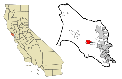
Location in Marin County and the state of California
|
|
| Country | |
| State | |
| County | Marin |
| Area | |
| • Total | 4.246 sq mi (11.00 km2) |
| • Land | 4.246 sq mi (11.00 km2) |
| • Water | 0 sq mi (0 km2) 0% |
| Population
(2020)
|
|
| • Total | 1,924 |
| • Density | 453.13/sq mi (174.96/km2) |
| Time zone | UTC-8 (PST) |
| • Summer (DST) | UTC-7 (PDT) |
| ZIP codes |
94933 (Forest Hills)
94938 (Lagunitas) |
| Area codes | 415/628 |
| FIPS code | 06-39283 |
Lagunitas-Forest Knolls is a special community made up of two smaller areas, Lagunitas and Forest Knolls. It's located in the western part of Marin County, California. You'll find it west of the towns San Geronimo and Woodacre. In 2020, about 1,924 people lived there.
Even though they are grouped together, Lagunitas and Forest Knolls feel like separate towns. They are divided by narrow parts of the San Geronimo Valley. Each town has its own small shops and services. Both areas are mostly places where people live. The ZIP code for Lagunitas is 94938, and for Forest Knolls it is 94933.
Contents
Exploring Lagunitas-Forest Knolls Geography
Lagunitas-Forest Knolls is located at 38 degrees North latitude and 122 degrees West longitude. The entire area covers about 4.246 square miles (11.0 square kilometers). All of this area is land, with no large bodies of water.
Rivers and Wildlife
San Geronimo Creek (also called Paper Mill Creek) flows through both towns. This creek is very important because it's one of the last places where Coho salmon can lay their eggs. These salmon are an endangered species.
Lagunitas Creek, which flows into San Geronimo Creek, is home to the largest group of wild Coho salmon in Central California. These salmon are a special type that are listed as "endangered" by both state and federal governments.
Natural Surroundings
The towns are at the western end of the San Geronimo Valley. They stretch into the green, forested hills to the south and a bit into the grassier hills to the north.
Lagunitas is right next to Samuel P. Taylor State Park. Like the park, Lagunitas-Forest Knolls is very green. It has many areas covered with tall evergreen trees.
People enjoy hiking and horseback riding in the hills above the towns.
Population and Community Life
| Historical population | |||
|---|---|---|---|
| Census | Pop. | %± | |
| 2010 | 1,819 | — | |
| 2020 | 1,924 | 5.8% | |
| U.S. Decennial Census | |||
The population of Lagunitas-Forest Knolls has grown slightly over the years. In 2010, there were 1,819 people, and by 2020, the population increased to 1,924.
Who Lives Here? (2010 Census)
In 2010, most of the people living in Lagunitas-Forest Knolls were White (about 91%). A smaller number of residents were African American, Native American, or Asian. About 7% of the population was of Hispanic or Latino background.
Most people lived in family homes. There were 817 households in total. About 26% of these homes had children under 18. Many households were married couples, but there were also single-parent homes and people living alone. The average household had about 2.22 people.
The ages of people living here varied. About 19% were under 18, and 13% were 65 or older. The average age was about 49 years old.
Most homes (about 67%) were owned by the people living in them, while the rest were rented.
Education in the Area
Students in Lagunitas-Forest Knolls attend schools in two different districts. Younger students go to schools in the Lagunitas Elementary School District. Older students, in high school, attend schools within the Tamalpais Union High School District.
See also
 In Spanish: Lagunitas-Forest Knolls para niños
 | Mary Eliza Mahoney |
 | Susie King Taylor |
 | Ida Gray |
 | Eliza Ann Grier |


