Lagunitas, California facts for kids
Quick facts for kids
Lagunitas
|
|
|---|---|

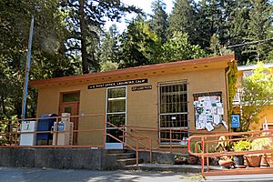
U.S. Post Office in Lagunitas
|
|
| Country | United States |
| State | California |
| County | Marin County |
| Elevation | 217 ft (66 m) |
Lagunitas is a small place in Marin County, California. Its name comes from the Spanish word Laguna, which means "Little lagoons." It is called an unincorporated community. This means it is not officially a city or town, but it is still a recognized place where people live.
Lagunitas is about 10 miles (16 km) southwest of Novato. It sits at an elevation of 217 feet (66 meters) above sea level. The U.S. Census groups Lagunitas with a nearby community called Forest Knolls. Together, they are known as Lagunitas-Forest Knolls.
The first post office in Lagunitas opened in 1906. The area's ZIP Code is 94938.
Contents
Exploring Lagunitas' Location
Lagunitas is in a hilly part of Marin County. It is located just north of Kent Lake. To its east, you will find Samuel P. Taylor State Park. Kent Lake is an important water source. It feeds into Lagunitas Creek. This creek then flows into Tomales Bay and eventually reaches the Pacific Ocean.
Who Lives in Lagunitas?
The U.S. Census counts the people in Lagunitas together with those in Forest Knolls. These two communities share a population of 1,924 people.
Learning in Lagunitas
Students in Lagunitas attend schools in the Lagunitas School District. They also go to high schools in the Tamalpais Union High School District.
The Lagunitas School District has two elementary schools. These schools are on the same property and share a principal. One of them is the only public Montessori school in Marin County. Montessori schools use a special teaching method that lets students learn at their own pace. There is also a middle school for grades 6-8.
Getting Around Lagunitas
Roads and Driving
The main road in Lagunitas is Sir Francis Drake Boulevard. This road stretches from California State Route 1 near Point Reyes Station. It goes all the way to Interstate 580 near San Rafael. Sir Francis Drake Boulevard is the only road that leads into and out of Lagunitas by land.
Public Buses
Lagunitas has public bus service provided by Marin Transit. There is a bus stop on Sir Francis Drake Boulevard at Cintura Avenue. This stop is part of bus route 68. This route connects Lagunitas to Inverness and the San Rafael Transit Center. From the San Rafael Transit Center, you can connect to other bus routes. You can also connect to Golden Gate Transit and Sonoma–Marin Area Rail Transit (SMART). These services can help you travel to other parts of the Bay Area.
Airports Nearby
Lagunitas does not have its own airport. However, it is about the same distance from three major airports. These are San Francisco International Airport (SFO), Oakland International Airport (OAK), and Sonoma County Airport (STS). SFO has the most international flights. You can reach SFO by driving on U.S. Route 101. This highway connects to Sir Francis Drake Boulevard near San Rafael. U.S. 101 and SMART also link directly to STS.
 | Audre Lorde |
 | John Berry Meachum |
 | Ferdinand Lee Barnett |


