San Geronimo, California facts for kids
Quick facts for kids
San Geronimo
|
|
|---|---|

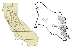
Location in Marin County and the state of California
|
|
| Country | |
| State | |
| County | Marin |
| Area | |
| • Total | 1.508 sq mi (3.91 km2) |
| • Land | 1.508 sq mi (3.91 km2) |
| • Water | 0 sq mi (0 km2) 0% |
| Elevation | 292 ft (89 m) |
| Population
(2020)
|
|
| • Total | 510 |
| • Density | 338/sq mi (130.6/km2) |
| Time zone | UTC-8 (Pacific) |
| • Summer (DST) | UTC-7 (PDT) |
| ZIP code |
94963
|
| Area codes | 415/628 |
| FIPS code | 06-67070 |
| GNIS feature ID | 232399 |
San Geronimo (which means "Saint Jerome" in Spanish) is a small community in Marin County, California in the United States. It's known as a census-designated place, which is a special area set up by the government for counting people.
San Geronimo is located in the San Geronimo Valley. To its west, you'll find Lagunitas-Forest Knolls. To its east, it borders Woodacre. The community is about 8 miles (13 km) southwest of downtown Novato. It sits at an elevation of about 292 feet (89 meters) above sea level. In 2020, about 510 people lived in San Geronimo.
Contents
History of San Geronimo
The San Geronimo Valley first appeared on a map in 1834. Before 1877, this area was known by a different name: Nicasio.
The San Geronimo post office opened its doors in 1895. It closed for a short time in 1910 but then reopened in 1911.
Geography and Location
San Geronimo is located at coordinates 38°00′48″N 122°39′50″W. The United States Census Bureau says that the community covers a total area of about 1.5 square miles (3.9 square kilometers). All of this area is land.
San Geronimo was once home to the San Geronimo Golf Course. In 2018, a group called The Trust for Public Land bought the 157-acre (64-hectare) site. They have opened it up for everyone to enjoy as a park. They are also working to restore the natural environment there.
Who Lives in San Geronimo?
Let's look at the people who call San Geronimo home.
San Geronimo's Population in 2010
In 2010, the population of San Geronimo was 446 people. Most of the residents, about 94.4%, were White. A small number of people were African American, Native American, or Asian. About 4.7% of the population identified as Hispanic or Latino.
All of the people counted in the census lived in homes. There were 199 households in total. Many of these were married couples living together. Some households had children under 18. The average household had about 2.24 people.
The ages of the people living in San Geronimo varied. About 16.1% were under 18 years old. The largest group, 42.4%, were between 45 and 64 years old. The average age was 50 years.
Most homes in San Geronimo were owned by the people living in them (73.4%). The rest were rented (26.6%).
San Geronimo's Population in 2000
In 2000, San Geronimo had 436 people living there. There were 174 households. The racial makeup was similar to 2010, with most people being non-Hispanic White.
About 28.7% of households had children under 18. The average household size was 2.47 people. The average family size was 2.70 people.
The average age in 2000 was 44 years. About 17.9% of the population was under 18.
The median income for a household was $58,542. This means half of the households earned more than this, and half earned less. The median income for a family was $60,875. About 10.4% of the population lived below the poverty line.
Education in San Geronimo
Children in San Geronimo attend schools in two different districts. Younger students go to schools in the Lagunitas Elementary School District. Older students, in high school, attend schools within the Tamalpais Union High School District.
See also
 In Spanish: San Gerónimo (California) para niños
 | Charles R. Drew |
 | Benjamin Banneker |
 | Jane C. Wright |
 | Roger Arliner Young |


