Laingsburg, Michigan facts for kids
Quick facts for kids
Laingsburg, Michigan
|
|
|---|---|
| City of Laingsburg | |

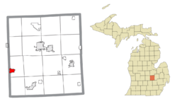
Location within Shiawassee County
|
|
| Country | United States |
| State | Michigan |
| County | Shiawassee |
| Incorporated | 1871 (village) 1951 (city) |
| Government | |
| • Type | Mayor–council |
| Area | |
| • Total | 1.70 sq mi (4.39 km2) |
| • Land | 1.59 sq mi (4.11 km2) |
| • Water | 0.11 sq mi (0.28 km2) |
| Elevation | 833 ft (254 m) |
| Population
(2020)
|
|
| • Total | 1,424 |
| • Density | 897.29/sq mi (346.37/km2) |
| Time zone | UTC-5 (Eastern (EST)) |
| • Summer (DST) | UTC-4 (EDT) |
| ZIP code(s) |
48848
|
| Area code(s) | 517 |
| FIPS code | 26-44200 |
| GNIS feature ID | 1626570 |
Laingsburg (pronounced LANGS-burg) is a small city in Shiawassee County, Michigan, in the United States. It's a friendly place with a population of 1,424 people, according to the 2020 census.
This city is located about 20 miles (32 km) northeast of Lansing, a larger city in Michigan. Laingsburg is mostly surrounded by Sciota Township. A small part of its western border touches Victor Township in Clinton County. The area covered by Laingsburg's 48848 ZIP Code is much larger than the city itself. It includes parts of Sleepy Hollow State Park and Lake Ovid to the northeast.
Laingsburg got its name from Dr. Peter Laing. He was an important person in the early days of the settlement and ran a local tavern.
Contents
Exploring Laingsburg's Location
Laingsburg covers a total area of about 1.69 square miles (4.39 square kilometers). Most of this area, 1.47 square miles (4.11 square kilometers), is land. The remaining 0.22 square miles (0.28 square kilometers) is water, making up about 13% of the city's total area.
Nearby Natural Areas
The city is close to some cool natural spots. You can find the Rose Lake State Wildlife Research Area nearby. Sleepy Hollow State Park is also very close to Laingsburg. These areas offer great opportunities to explore nature.
Getting to Laingsburg
Laingsburg has clear exits on major roads. You can reach it from U.S. Route 127 to the west. There are also exits from Interstate 69 to the south. This makes it easy to visit the city.
Laingsburg's Growing Population
The city of Laingsburg has seen its population grow over the years. Here's a quick look at how many people have lived here:
| Historical population | |||
|---|---|---|---|
| Census | Pop. | %± | |
| 1880 | 616 | — | |
| 1890 | 654 | 6.2% | |
| 1900 | 690 | 5.5% | |
| 1910 | 703 | 1.9% | |
| 1920 | 693 | −1.4% | |
| 1930 | 767 | 10.7% | |
| 1940 | 896 | 16.8% | |
| 1950 | 942 | 5.1% | |
| 1960 | 1,057 | 12.2% | |
| 1970 | 1,159 | 9.6% | |
| 1980 | 1,145 | −1.2% | |
| 1990 | 1,148 | 0.3% | |
| 2000 | 1,223 | 6.5% | |
| 2010 | 1,283 | 4.9% | |
| 2020 | 1,424 | 11.0% | |
| U.S. Decennial Census | |||
Who Lives in Laingsburg? (2010 Census)
In 2010, there were 1,283 people living in Laingsburg. These people lived in 463 households, and 335 of these were families. The city had about 873 people per square mile (337 people per square kilometer). There were also 536 housing units, which are homes or apartments.
Most people in Laingsburg were White (96.6%). A small number were African American (0.4%), Native American (0.4%), or Asian (0.4%). About 1.9% of the population identified as two or more races. People of Hispanic or Latino background made up 1.4% of the population.
Many households (44.7%) had children under 18 living with them. About half (49.5%) were married couples. Some households (15.8%) had a female head with no husband present. Others (7.1%) had a male head with no wife present. About 27.6% of households were not families.
The average age in the city was 33.3 years old. About 31.6% of residents were under 18. About 9.5% were 65 years old or older. The population was almost evenly split between males (50.3%) and females (49.7%).
See also
 In Spanish: Laingsburg (Míchigan) para niños
 | Jackie Robinson |
 | Jack Johnson |
 | Althea Gibson |
 | Arthur Ashe |
 | Muhammad Ali |


