Lake Alan Henry facts for kids
Quick facts for kids Lake Alan Henry |
|
|---|---|
 |
|
| Location | Garza County, Texas, United States |
| Coordinates | 33°03′33.0″N 101°03′09.8″W / 33.059167°N 101.052722°W |
| Type | Reservoir |
| Primary inflows | Double Mountain Fork Brazos River |
| Basin countries | United States |
| Surface area | 2,880 acres (1,170 ha) |
| Max. depth | 100 ft (30 m) |
| Surface elevation | 2,200 ft (670 m) |
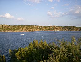
Lake Alan Henry is a large lake, also called a reservoir, located in the western part of Texas, United States. It was created in 1993 when the John T. Montford Dam was built. The city of Lubbock, Texas, uses it for fun activities and plans to use its water in the future. The lake covers about 2,880 acres (1,170 ha) and is usually about 40 ft (12 m) deep. You can find Lake Alan Henry about 4 mi (6.4 km) east of Justiceburg, Texas and 45 mi (72 km) south of Lubbock.
Where is Lake Alan Henry?
Lake Alan Henry is located on the Double Mountain Fork Brazos River in West Texas. It is south of Lubbock and east of Justiceburg. The lake stretches for about 11 mi (18 km) and has over 56 mi (90 km) of shoreline.
The lake's surface is about 1,000 ft (300 m) lower than the city of Lubbock. Lake Alan Henry can be as deep as 100 ft (30 m), but its average depth is 40 ft (12 m). The water is usually a bit cloudy, and you can see about one to four feet deep into it. The water level in the lake changes a little, usually by two to four feet each year. Most of the plant life in the lake is made up of trees that were flooded when the lake was created.
If Lake Alan Henry is completely full, it could hold more than 40 billion gallons of water!
Fish in the Lake
Lake Alan Henry has been stocked with many different types of fish. This was done to make it a great place for fishing and other water activities. Fish stocking started in 1993 with adult shad and gizzard fish.
Between 1993 and 1994, the Texas Parks and Wildlife Department added more fish. These included largemouth bass, white crappie, smallmouth bass, and channel catfish. It's important to know that there's a warning about eating certain types of fish from the lake. This is because some fish have higher levels of natural substances like mercury. Always check local guidelines before eating fish from any lake.
How Lake Alan Henry Was Made
In the 1960s, the city of Lubbock started looking for a new water source. Their population was growing, and they needed more water. After many years of studying the soil and doing engineering research, they chose the spot where the John T. Montford Dam now stands. This location was the best and closest place for the dam and the lake it would create.
The Army Corps of Engineers approved the plan. Design work for the dam began in the 1980s. Construction started in 1991, and it took two years to finish. The dam was completed and began working in 1993. The dam was named after Senator John Thomas Montford. He worked hard to pass laws that helped create the reservoir. The lake itself was named after a former mayor of Lubbock, Alan Henry.
In 1994, as the lake began to fill with water, Lubbock city officials started a water testing program. This program was to collect information about the water quality. Before the lake's water can be used for the city, a lot more work needs to be done. This includes building three pumping stations, a new water treatment plant, and about 65 mi (105 km) of pipeline between Lubbock and Lake Alan Henry. Once all this is ready, the lake could provide up to 23 million gallons of water per day for Lubbock.
Today, Lake Alan Henry is mainly a fun place for people to visit. Fishing, water skiing, hunting, hiking, and camping are popular activities. The Sam Wahl Recreational Area, which is part of the lake area, covers over 580 acres (230 ha).
 | Misty Copeland |
 | Raven Wilkinson |
 | Debra Austin |
 | Aesha Ash |


