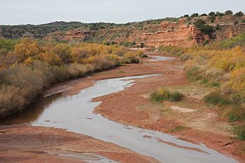
Double Mountain Fork Brazos River facts for kids
Quick facts for kids Double Mountain Fork Brazos River |
|
|---|---|

Double Mountain Fork, Fisher County, Texas
|
|
| Country | United States |
| State | Texas |
| Physical characteristics | |
| Main source | Llano Estacado, 18.5 km southeast of Tahoka, Texas Lynn County, Texas 890 m (2,920 ft) 33°03′19″N 101°38′17″W / 33.05528°N 101.63806°W |
| River mouth | Confluence Double Mountain / Salt Fork Stonewall County, Texas 451 m (1,480 ft) 33°16′03″N 100°00′38″W / 33.26750°N 100.01056°W |
| Length | 280 km (170 mi) |
| Basin features | |
| Basin size | 7,097 km2 (2,740 sq mi) |
The Double Mountain Fork Brazos River is a special kind of stream in West Texas. It is about 170 mi (280 km) long. This river is called ephemeral, which means it doesn't always have water flowing. It often looks like a wide, sandy path with many small channels, like a braid.
This river starts in a high, flat area called the Llano Estacado. Its source is about 11.5 mi (18.5 km) southeast of a town called Tahoka, Texas. The Double Mountain Fork flows generally east-northeast. It crosses a region known as the Western Rolling Plains. Finally, it joins another river, the Salt Fork. When these two rivers meet, they form the main Brazos River. This meeting point is about 18 mi (29 km) west-northwest of Haskell, Texas.
Contents
Where Does the River Flow?
The Double Mountain Fork Brazos River begins in Lynn County. It starts as a shallow dip in the land, close to the eastern edge of the Llano Estacado. This starting point is about 3.1 mi (5 km) northeast of a small farming town called Draw, Texas.
Journey Through Texas Counties
From its start, the stream generally flows east. It crosses the southern part of Garza County. In this area, underground springs help feed the river. These springs provide a small amount of water that usually flows. However, the river's water level can change a lot. It gets much more water when it rains, causing runoff.
As the river reaches the western edge of Kent County, it meets another stream. This is the North Fork Double Mountain Fork Brazos River. This meeting happens about 12 mi (20 km) east-northeast of Justiceburg. After this, the Double Mountain Fork continues its journey eastward.
The river then flows across southern Kent County. It also goes through northwestern Fisher County. Finally, it enters southern Stonewall County. Here, it passes south of some interesting landforms. These are the Double Mountains.
The Double Mountains and River's End
The Double Mountains are a pair of flat-topped hills. They are located about 13 mi (21 km) southwest of Aspermont, Texas. These mountains are important because they create a natural divide. They separate the areas where water flows into the Salt Fork (to the north) from where it flows into the Double Mountain Fork (to the south).
After passing the Double Mountains, the Double Mountain Fork flows into western Haskell County. Then, it turns north and goes back westward. It enters eastern Stonewall County again. This is where it finally joins the Salt Fork. Together, they form the main Brazos River. This important meeting point is northeast of Aspermont, Texas.
What's in a Name?
It's important to use the correct name for this river. In 1964, a group called the United States Board on Geographic Names made a decision. They said the proper name for this river is "Double Mountain Fork Brazos River".
Common Mistakes in Naming
Sometimes, people mistakenly call it "Double Mountain Fork of the Brazos River" or "Double Mountain Fork of Brazos River". These are not the official names. Another common mistake is calling it the "South Fork of the Double Mountain Fork of the Brazos River." This might happen because there is also a North Fork Double Mountain Fork Brazos River. The North Fork is a smaller stream that flows into the Double Mountain Fork.
However, the river we are talking about here is the main part of the Double Mountain Fork Brazos River. It doesn't flow into another part of the Double Mountain Fork. Instead, it flows directly into the Brazos River itself. So, it's a tributary of the Brazos River.
 | Sharif Bey |
 | Hale Woodruff |
 | Richmond Barthé |
 | Purvis Young |

