
North Fork Double Mountain Fork Brazos River facts for kids
Quick facts for kids North Fork Double Mountain Fork Brazos River |
|
|---|---|

North Fork flowing through Yellow House Canyon
|
|
| Country | United States |
| State | Texas |
| Physical characteristics | |
| Main source | Confluence of Yellow House Draw and Blackwater Draw Mackenzie Park, Lubbock, Texas 3,146 ft (959 m) 33°35′34″N 101°50′02″W / 33.59278°N 101.83389°W |
| River mouth | Confluence with Double Mountain Fork Kent County, Texas 2,096 ft (639 m) 33°06′03″N 101°00′01″W / 33.10083°N 101.00028°W |
| Length | 75 mi (121 km) |
| Basin features | |
| Basin size | 1,050 sq mi (2,700 km2) |
The North Fork Double Mountain Fork Brazos River is a stream in West Texas. It is about 75 miles (121 km) long. This river starts where two smaller streams, Blackwater Draw and Yellow House Draw, meet in Lubbock.
The North Fork flows mostly southeast. It ends when it joins the Double Mountain Fork Brazos River in Kent County. This river flows through parts of Lubbock, Crosby, Garza, and Kent counties.
The flowing water of the North Fork helped create Yellow House Canyon. This is one of three big canyons found on the east side of the Llano Estacado, a large flat area of land.
Contents
What's in a Name?
This river has had a few different names over time. Some people used to call it Yellowhouse Creek or Yellow House River. But in 1964, the United States Board on Geographic Names made a decision.
They officially named it the North Fork Double Mountain Fork Brazos River. This name is quite long! So, most people just call it the North Fork for short.
Journey of the North Fork River
Inside the city of Lubbock, the North Fork is a small stream. It flows through a narrow and shallow channel. The channel is usually less than 1,500 feet (457 m) wide and not more than 50 feet (15 m) deep.
The city of Lubbock has built several small dams here. These dams create a series of narrow lakes. These lakes are known together as the Canyon Lakes.
Yellow House Canyon's Growth
As the North Fork leaves Lubbock, Yellow House Canyon gets wider and deeper. About 9 miles (14 km) southeast of Lubbock, there is a dam. This dam created Buffalo Springs Lake.
This lake covers the original Buffalo Springs, but the springs still flow underwater. Right below Buffalo Springs Lake is another smaller dam. This dam forms Lake Ransom Canyon. Many homes are built around this lake, creating the community of Ransom Canyon, Texas.
Flowing Through Ranch Land
After Ransom Canyon, the North Fork flows freely. It passes through ranch country where not many people live. The canyon continues to get deeper and wider here.
Where the North Fork crosses Farm to Market Road 400, cleaned water from Lubbock's water treatment plant is added to the stream. This happens at a spot called Outfall 001. The city is allowed to add a lot of cleaned water to the North Fork each day.
Canyon's End and River's Merge
Where the North Fork crosses Lubbock County Road 3600, the canyon is almost 2 miles (3.2 km) wide. It is also about 200 feet (61 m) deep. Further downstream, the canyon walls start to curve outward.
The North Fork then leaves Yellow House Canyon. It flows onto the rolling plains of West Texas. East of Slaton, the North Fork enters Crosby County. It passes near Courthouse Mountain and the old town of Canyon Valley.
After flowing about 8 miles (13 km) through Crosby County, the stream enters Garza County. It continues southeast, crossing Texas State Highway 207. It passes northeast of Post. Then it crosses Farm to Market Road 651 and U.S. Highway 380.
This is about 7 miles (11 km) east of Post. The stream then starts to turn more to the east. It winds a lot before moving from Garza into Kent County. Finally, it joins the Double Mountain Fork.
From where it starts to where it joins the Double Mountain Fork, the North Fork drops about 1,050 feet (320 m). It flows through land that is mostly flat to moderately sloped.
Future Plans: Post Reservoir
The City of Lubbock has suggested building a large reservoir. This reservoir would hold water from the North Fork northeast of Post. It would be about 60% the size of Lake Alan Henry. Lake Alan Henry is another reservoir for the city, located on the Double Mountain Fork.
The proposed Post Reservoir is an important part of the 2012 State Water Plan. This plan is for the Llano Estacado area, which includes 21 counties. Building this reservoir could put two rare types of prairie fish at risk. These fish are the smalleye shiner and the sharpnose shiner.
Images for kids
-
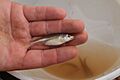
Smalleye shiner, a fish that could be affected by the proposed Post Reservoir
-
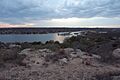
Lake Ransom Canyon, a lake on the upper North Fork
-
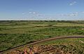
Yellow House Canyon, carved by the North Fork, near Slaton, Texas
-
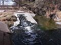
Outfall 001, where cleaned water from Lubbock is added to the North Fork
_(7417357986).jpg)


