Salt Fork Brazos River facts for kids
Quick facts for kids Salt Fork Brazos River |
|
|---|---|

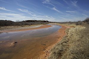
Salt Fork in Kent County, Texas
|
|
| Physical characteristics | |
| Main source | Crosby County, Texas 3,027 ft (923 m) 33°28′38″N 101°25′20″W / 33.477133°N 101.422361°W |
| River mouth | Stonewall County, Texas 1,483 ft (452 m) 33°16′03″N 100°00′38″W / 33.2675°N 100.010556°W |
| Length | 150 mi (240 km) |
| Basin features | |
| River system | Brazos |
| Basin size | 2,150 sq mi (5,600 km2) |
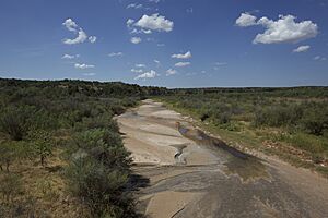
The Salt Fork Brazos River is a river in Texas that is about 150 mi (240 km) long. It starts near Lubbock, Texas, at the edge of a flat area called the Llano Estacado. This river is known as a "braided" stream because it often splits into many smaller channels that weave together. It's also "intermittent," meaning it doesn't always have water flowing in it, especially during dry times.
The Salt Fork Brazos River flows generally southeast. It eventually joins another river, the Double Mountain Fork, to form the larger Brazos River. This happens near Haskell, Texas. The Salt Fork Brazos River passes through several counties in West Texas, including Crosby, Garza, Kent, and Stonewall counties.
Contents
Where Does the Salt Fork Brazos River Start?
The Salt Fork Brazos River begins as a dry channel, which is like a ditch that only carries water after it rains a lot. This channel is located in Crosby County, Texas, near a small farming town called Cap Rock, Texas.
Journey Through Crosby County
From its start, the river channel flows southeast through southern Crosby County. It goes past a place called Courthouse Mountain and crosses Texas State Highway 207. It also passes near the old community of Canyon Valley.
Flowing into Garza and Kent Counties
Next, the Salt Fork Brazos River enters Garza County. It passes Duffy's Peak and crosses Farm to Market Road 651. Here, it meets another stream called McDonald Creek. The river then starts to turn more to the east and winds its way into Kent County.
In Kent County, the Salt Fork Brazos River joins the White River. It then flows under Farm to Market Road 1081. The river continues to twist and turn, crossing Texas State Highway 208 near Clairemont and U.S. Highway 380 near Jayton.
Reaching Stonewall County and Joining the Brazos River
After Kent County, the Salt Fork Brazos River moves into Stonewall County. Here, it makes a sharp turn north. It crosses Highway 380 again and passes north of Peacock and Swenson.
This northern turn is because of high ground around a pair of flat-topped hills called Double Mountain. These mountains separate the areas where the Salt Fork (to the north) and the Double Mountain Fork (to the south) collect their water. Finally, at the eastern edge of Stonewall County, the Salt Fork Brazos River meets the Double Mountain Fork. When these two rivers join, they officially form the main Brazos River.
From where it starts to where it joins the Double Mountain Fork, the Salt Fork Brazos River drops about 1,544 ft (471 m) in height. It flows through land that is mostly flat but can also be quite steep in some places.
What's in a Name?
In 1964, a group called the United States Board on Geographic Names made an important decision about the river's name. They decided that the correct name is "Salt Fork Brazos River." It should not be called "Salt Fork of the Brazos River." This helps everyone use the same official name for this river.
 | James B. Knighten |
 | Azellia White |
 | Willa Brown |


