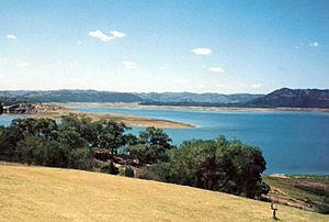
Burrendong Dam facts for kids
Quick facts for kids Burrendong Dam |
|
|---|---|

Lake Burrendong, New South Wales, Australia
|
|
|
Location of the Burrendong Dam
in New South Wales |
|
| Country | Australia |
| Location | Wellington, New South Wales |
| Coordinates | 32°40′4″S 149°6′25″E / 32.66778°S 149.10694°E |
| Purpose | Flood mitigation, irrigation, water supply |
| Status | Operational |
| Construction began | 1958 |
| Opening date | 1967 |
| Owner(s) | State Water Corporation |
| Dam and spillways | |
| Type of dam | Embankment dam |
| Impounds | Macquarie River |
| Height | 76 metres (249 ft) |
| Length | 1,116 metres (3,661 ft) |
| Dam volume | 1,188,000 megalitres (42,000×106 cu ft) |
| Spillways | One |
| Spillway type | Gated concrete chute |
| Spillway capacity | 13,720 cubic metres per second (485,000 cu ft/s) |
| Reservoir | |
| Creates | Lake Burrendong |
| Total capacity | 1,188 gigalitres (4.20×10¹⁰ cu ft) |
| Catchment area | 13,886 square kilometres (5,361 sq mi) |
| Surface area | 8,900 hectares (22,000 acres) |
| Normal elevation | 344 metres (1,129 ft) AMSL |
| Power station | |
| Operator(s) | AGL Energy |
| Commission date | 1996 |
| Type | Conventional |
| Installed capacity | 19 megawatts (25,000 hp) |
| Annual generation | 50.9 gigawatt-hours (183 TJ) |
| Website Burrendong Dam |
|
The Burrendong Dam is a large dam located in the central west of New South Wales, Australia. It sits across the Macquarie River, near the town of Wellington. This important dam helps control floods, provides water for farms (irrigation), supplies drinking water, and even generates electricity. The dam creates a big lake called Lake Burrendong, which collects water from the Macquarie and Cudgegong rivers, and Meroo Creek.
Contents
Building the Burrendong Dam
The idea for Burrendong Dam first came up in 1909. But it took many years for the plans to become real. In 1946, laws were passed to allow the dam to be built. Construction started in 1950.
During the building process, the nearby town of Mumbil grew. It provided homes for all the workers. The dam was finished in April 1965. Water began to fill the new Lake Burrendong for the first time.
The dam was officially opened on 18 August 1967. Robert Askin, who was the leader of New South Wales at the time, attended the ceremony. This date was special because it marked 150 years since the town of Wellington was founded. By September 1969, the dam was almost completely full.
Sadly, an old gold-mining village called Burrendong was covered by water when the dam was built.
Where is Burrendong Dam and What Does It Do?
Burrendong Dam is about 30 kilometers (18 miles) southeast of Wellington. It sits on the Macquarie River. The dam's main jobs are to stop floods, provide water for farms, and supply drinking water.
Dam Size and Water Storage
The dam wall is 76 meters (249 feet) tall and 1,116 meters (3,661 feet) long. When the dam is full, the water can be 57 meters (187 feet) deep. The lake's surface covers about 7,200 hectares (17,791 acres). The area that collects water for the dam is huge, about 13,900 square kilometers (5,367 square miles).
The dam can hold a massive amount of water. Its full capacity is 1,188,000 megalitres (314 billion US gallons). It also has extra space to hold 480,000 megalitres (127 billion US gallons) of water just for flood control. A special concrete channel called a spillway helps release water safely. It can let out 13,720 cubic meters (484,500 cubic feet) of water per second.
Managing Water Levels
The dam's water level can change a lot. During very dry times, like droughts, the water level has dropped to as low as 1.5%. This happened in January 2020, for example.
However, the dam is also very good at preventing floods. It has stopped big floods from damaging towns downstream. For instance, in 1990, the dam held 160% of its normal capacity. In 2010, it reached 152.8% capacity, safely managing the extra water.
Dam Upgrades for Safety
A big upgrade project for the dam started in 2010. This project cost 32 million Australian dollars. It was completed in 2015. The upgrades made the dam even safer. They included making the main dam wall and a smaller "saddle dam" 1.8 meters (6 feet) taller. Changes were also made to the spillway. A new auxiliary spillway and a fuse plug were added too.
Generating Clean Energy
Burrendong Dam also helps create clean energy! A special power station uses the flowing water to generate electricity. This is called hydroelectricity. The station can produce up to 19 megawatts of power. On average, it generates 50.9 gigawatt-hours of electricity each year.
The power station was finished in August 1996. It was officially opened on 9 February 1999 by Bob Carr, who was the leader of New South Wales then. Today, AGL Energy manages this power station.
Future Energy Plans
In early 2025, a large pumped-storage hydroelectricity project won a state tender. This project is planned for an area east of the lake. It will not use the lake itself. The project involves building two new reservoirs. These reservoirs are designed to have a height difference of 350 meters (1,148 feet). The estimated cost for this project is around 1.8 billion Australian dollars.
See also
 | Precious Adams |
 | Lauren Anderson |
 | Janet Collins |


