
Lake Great Falls facts for kids
Quick facts for kids Lake Great Falls |
|
|---|---|
.jpg)
Glacial Lake Great Falls.
|
|

Lake Great Falls
Location in Montana
|
|
| Location | Cascade, Montana |
| Coordinates | 47°30′14″N 111°17′11″W / 47.503784°N 111.286353°W |
| Lake type | Glacial lake (former) |
| Primary inflows | Laurentide Ice Sheet |
| Primary outflows | Along the face of the Ice sheet. |
| Basin countries | United States |
| Max. length | about 26 miles (42 km) |
| Max. width | about 7.8 miles (12.6 km) |
| Surface area | varied |
| Surface elevation | 3,500 m (11,500 ft) |
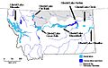
Lake Great Falls was a giant glacial lake that existed a very long time ago. It was located in what is now central Montana in the United States. This huge lake was around between 15,000 and 11,000 years before the Common Era (BCE).
The lake was centered where the modern city of Great Falls, Montana is today. It stretched far north to Cut Bank, Montana and south to Holter Lake. Near present-day Great Falls, the lake was incredibly deep, reaching about 600 feet (183 meters)!
How Lake Great Falls Formed
Long before Lake Great Falls, about 1.5 million years ago, big rivers like the Missouri River, Yellowstone River, and Musselshell River flowed north. They emptied into a lake that had no outlet to the ocean.
But then, during the last Ice Age, huge sheets of ice called the Laurentide and Cordilleran glaciers moved south. They pushed these rivers and lakes with them. Between 15,000 and 11,000 BCE, the Laurentide ice sheet blocked the Missouri River. This blockage caused water to back up, forming the massive Glacial Lake Great Falls.
How the Lake Disappeared
Around 13,000 BCE, the giant glacier started to melt and shrink. As the ice retreated, Glacial Lake Great Falls emptied very quickly in a huge glacial lake outburst flood. This was like a massive, sudden release of water.
The meltwater from the lake poured through the Highwood Mountains. It carved out a long, deep channel called the Shonkin Sag. This channel is about 100 miles long and 500 feet deep. It is one of the most famous prehistoric meltwater channels in the world.
Images for kids
-
Map of Montana showing glacial lakes.

