
Lake Mahinapua facts for kids
Quick facts for kids Lake Mahinapua |
|
|---|---|
| Lake Māhinapua, Tāwiri a Te Makō | |
 |
|

Lake Mahinapua
Location in West Coast
|
|
| Location | West Coast, South Island, New Zealand |
| Coordinates | 42°48′S 170°55′E / 42.800°S 170.917°E |
| Primary inflows | Frosty Creek, Mirror Creek |
| Primary outflows | Mahināpua Creek |
| Basin countries | New Zealand |
| Max. length | 3 kilometres (1.9 mi) |
| Max. width | 2 kilometres (1.2 mi) |
| Surface area | 3 square kilometres (1.2 sq mi) |
| Surface elevation | 4 metres (13 ft) |
Lake Mahinapua is a beautiful, shallow lake on the West Coast of New Zealand's South Island. Long ago, it was a lagoon at the mouth of the Hokitika River. It became a lake when the river changed its path.
This lake is very important to the Māori. It was the site of a big battle between the Ngāi Tahu and Ngāti Wairangi tribes. Because of its history, Māori people see it as a sacred place. They do not swim or fish in its waters.
Later, when Europeans arrived, the lake was part of a waterway. Boats used it to carry wood and people between Hokitika and Ross. This continued until a railway was built. Today, Lake Mahinapua is a protected area. It is a great spot for boating, camping, and hiking.
Contents
What's in a Name?
The name of the lake comes from the Māori words. Māhina is a person's name, and pua means flower. So, the name means "Māhina's flower."
You might see the name written in different ways. Sometimes it is "Mahinapua" without a special mark. Other times, it is "Mahināpua" with a macron (a line) over the second "a." The official name for the nearby creek, Mahināpua Creek, uses the macron.
Where is Lake Mahinapua?

Lake Mahinapua is located next to State Highway 6. It is near the small town of Ruatapu. This town is found between Hokitika and Ross.
To reach the lake, you turn off the highway about 8 kilometres (5.0 mi) south of Hokitika. The road takes you through a tunnel of native forest. It leads right to the lake shore. There are also walking tracks around the lake. The Mahinapua Walkway starts about 10 kilometres (6.2 mi) south of Hokitika. It reaches the lake at Picnic Bay.
How Was the Lake Formed?
About 12,000 years ago, huge glaciers began to melt. As they retreated, they left behind piles of rock and dirt called moraines. These moraines formed along what is now the eastern side of the lake.
The Hokitika River used to flow to the sea through this area. It flowed between these moraines, where Lake Mahinapua is now. Over time, the sea level slowly rose. It pushed sand dunes in front of it. These dunes created a shallow lagoon about 500 metres (1,600 ft) from the Tasman Sea coast.
Then, the Hokitika River changed its path. It moved its mouth about 8 km north. This left the lagoon behind. Now, the lake is fed by several small creeks.
Plants and Animals of Lake Mahinapua
The forests around Lake Mahinapua are very diverse. On the higher ground, you can find rimu and kamahi trees. These grow on the old moraines left by the glaciers. Closer to the coast, there are different types of dune forests.
In the wet areas, like the northern and southern parts of the lake, you will see kahikatea swamp forests and flax. Flax grew very well along Mahināpua Creek. It was harvested for business after the forests were cleared. This area is special because it has a nearly unbroken forest. It stretches from the Southern Alps all the way to the Tasman Sea. Both southern rātā and northern rātā trees grow here. Lake Mahinapua is the southernmost place where northern rātā can be found.
What Birds Live Here?
Many waterbirds call Lake Mahinapua home. You can often see black swans and mallard ducks. Sometimes, you might spot Royal spoonbills, grey ducks, and fernbirds. White herons (kōtuku) visit the lake seasonally. They are also common in the streams that flow into or out of the lake.
Rarely, you might see the southern crested grebe or even bitterns. The surrounding bush is full of birds. These include bellbirds, tūī, kererū, and parakeets. You can also hear the calls of long-tailed and shining cuckoos. Brown creepers also live in the area.
Fish and Other Lake Life
Lake Mahinapua still has small groups of native fish. These include shortfin eels and īnanga. However, some fish that are not native to New Zealand have also moved in. These include perch, tench, and brown bullhead catfish. Luckily, another invasive fish called rudd has not yet settled in the lake.
The lake also has some invasive water plants. These are white waterlily (Nymphaea alba) and Cape pondweed (Aponogeton distachyos).
Lake Mahinapua's Human Story
Lake Mahinapua was very important to the Māori tribes of Pātea and Ngāti Wairangi. It was a mahinga kai, which means a place to gather food. They also collected kuta, a type of sedge, from the lake. This plant was important for weaving.
Later, tribes from outside the area started to get pounamu (greenstone) from the region. This led to more battles and raids. Lake Mahinapua was the site of a major battle in the late 1600s. This fight was between the Ngāi Tahu and Ngāti Wairangi tribes. During the battle, many Ngāi Tahu rafts (mokihi) were overturned. Many people lost their lives.
The battle was named Tāwiri a Te Makō, which means "heap of sharks." This name is also sometimes used for the lake itself. Because of this history, the battle site is a wāhi tapu, a sacred place. Local Ngāi Tahu people do not gather food from the lake or swim in it. The ownership of the lakebed was given to the Poutini Ngāi Tahu tribe. This happened as part of the Ngāi Tahu Claims Settlement Act 1998.
European Settlement and Transport
Before roads were built, the lake was very useful for European settlers. When the tide was high, small boats could travel from the lake down Mahināpua Creek to Hokitika. This was a big help for moving goods and people.
From 1865, boats carried people and cargo from Hokitika up the creek. They crossed the lake and unloaded at a special landing near Ruatapu. From there, they continued down a lagoon to Ross. In 1867, two small paddle steamers were built in Hokitika for this route. They used parts saved from shipwrecks. You can still see the remains of a later paddle steamer at Shanghai Bay.
From the 1880s to the 1960s, wood was cut from the coastal forest. Much of this was kahikatea timber. After the trees were cleared, flax was harvested along Māhinapua Creek. Both the timber and flax were taken back to Hokitika by barges or paddleboats. This continued until the Ross Branch railway opened. The railway reached Ruatapu in 1906 and Ross in 1909. It closed in 1980, but the historic Mahinapua Creek Railway Bridge has been saved. Mining and gold dredging also took place in the area. In 1901, only eleven people lived around Lake Mahinapua.
Protecting the Lake and Recreation
In 1893, almost 100 hectares of land along the creek and lake shore became a protected area. In 1907, the Lake Mahinapua Scenic Reserve was created. This reserve helps protect the land around the lake.
There are short walking tracks through the bush, like the Jum Michel Walk and Swimmers Beach Walk. There is also a longer walk, about 2 to 2½ hours. This track follows the path of an old logging tramline to the site of the Mananui Sawmill. In December 2012, the West Coast Treetop Walk opened nearby. It is on the edge of the Scenic Reserve.
Shanghai Bay, on the southwestern shore, became a recreation reserve in 1974. A campground and the Lake Mahinapua Aquatic Club are located there. Sailing, kayaking, and canoeing are popular activities. You can even kayak 9 km through forest and swampland to Hokitika. You can also kayak up Mirror Creek at the other end of the lake. Even though the lake is a sacred place for Māori, swimming, fishing, and duck hunting are common activities for others.
Images for kids
-
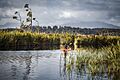
A kayaker on Mahināpua Creek
-
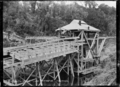
A dry land dredge operating at the lake
-
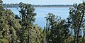
A view from a tower on the nearby West Coast Treetop Walk
-
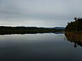
A beautiful reflection of the Southern Alps in the lake


See also
 In Spanish: Lago Mahinapua para niños
