Lake Nisqually facts for kids
Quick facts for kids Lake Nisqually |
|
|---|---|

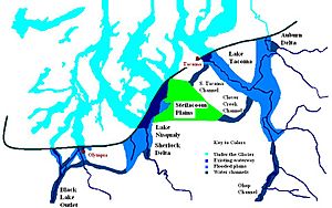
Glacial lakes Lake Tacoma, Lake Nisqually, and Lake Russell
|
|
| Location | Tacoma Pierce County, Washington |
| Coordinates | 47°13′02″N 122°34′52″W / 47.217332°N 122.581240°W |
| Lake type | Glacial lake (former) |
| Primary inflows | Lake Tacoma |
| Primary outflows | Black Lake |
| Basin countries | United States |
| Surface elevation | 288 m (945 ft) |
| References | Washington Geological Survey, Bulletin No. 8; Glaciation of the Puget Sound Region; J. Harlen Bretz; Olympia, Wash, Frank M. Lamborn Public Printer; 1913 |
Lake Nisqually was an ancient freshwater lake that existed long ago. It formed in a deep valley called the Puget Sound trough, which is west of Tacoma. This lake was created by melting glaciers.
Sometimes, Lake Nisqually is confused with an even older lake called Early Lake Russell. Early Lake Russell covered the same area when the glacier first started to melt and move north. But then the glacier moved south again. When it finally retreated north for the last time, the water that filled this valley became known as Lake Nisqually.
What Was Lake Nisqually Like?
Lake Nisqually drained its water through a path called the Black Lake channel. This channel was about 160 feet (49 m) above sea level.
How Did Deltas Form?
Two large areas of land, called deltas, grew along the eastern edge of Lake Nisqually. These deltas were formed by water flowing out of Lake Tacoma, which was in the Puyallup River valley. The two deltas were named Steilacoom and Sequalichew. They were also at about 160 feet (49 m) in height.
Later, the water level in Lake Nisqually rose to between 180 to 200 feet (55 to 61 m). This happened because the Black Lake channel, which was the lake's outlet, became blocked. Even with the higher water level, the Steilacoom and Sequalichew deltas continued to grow.
How Glaciers Changed the Lake
When the glacier moved forward enough to block the Black Lake outlet, it changed the path of the Nisqually River. The water from the Steilacoom Plains then flowed across areas called Chambers and Bush prairies instead.
During this time, the edge of the glacier stretched in a line from northeast to southwest, between Tacoma and Olympia. The areas where Lake Puyallup and Lake Tacoma were located were not greatly affected by this glacier movement. Water continued to flow through the Clover Creek and South Tacoma channels. The flat, gravelly areas around them adjusted to the new water level of 180 feet (55 m).
It seems that the narrow passage known as "the Narrows" became clear when the glacier retreated again. This caused the water level in Lake Tacoma to drop, and Lake Tacoma then became part of Lake Russell.
 | Isaac Myers |
 | D. Hamilton Jackson |
 | A. Philip Randolph |


