Lake Puyallup facts for kids
Quick facts for kids Lake Puyallup |
|
|---|---|

Glacial lakes Lake Puyallup & Early Lake Russell
|
|
| Location | Puyallup River Pierce County, Washington |
| Coordinates | 47°13′25″N 122°20′40″W / 47.223655°N 122.344414°W |
| Lake type | Glacial lake (former) |
| Primary inflows | Vashon Glacier |
| Primary outflows | Ohop channel |
| Basin countries | United States |
| Max. length | 17 miles (27 km) |
| Max. width | 9 miles (14 km) |
| Max. depth | 595 feet (181 m) |
| Residence time | less than 200 years |
| Surface elevation | 350 m (1,150 ft) |
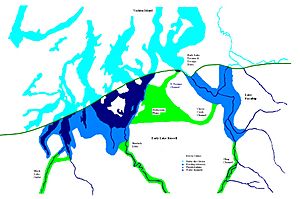
Imagine a huge lake that existed long ago, not filled by rain, but by melting ice! Lake Puyallup was one such amazing lake. It formed at the southern edge of a giant ice sheet called the Puget Sound Glacier. This glacier was slowly melting and moving back north after reaching its farthest point south.
The water from the melting glacier, along with runoff from the north side of Mount Rainier, got trapped in the valley of the Puyallup River. This created Lake Puyallup. As the glacier continued to retreat, the lake grew bigger and bigger. It reached its largest size when the glacier's front was just south of Commencement Bay near Tacoma and the northern bend of the White River at Auburn. When the ice moved even further north, the lake became shallower and smaller, eventually becoming known as Lake Tacoma.
How Lake Puyallup Formed
Lake Puyallup was a type of lake called a glacial lake. This means it was created by a glacier. Think of a giant ice plow pushing and shaping the land. As the Puget Sound Glacier melted and pulled back, it left behind a huge basin. Water filled this basin, forming the lake.
- The glacier was moving north, leaving a space for water to collect.
- Water flowed into the valley from the melting ice.
- Water also came from the slopes of Mount Rainier.
- The lake grew as the glacier retreated, filling the valley.
The Ohop Channel: Lake's First Drain
For a long time, Lake Puyallup had only one way for its water to flow out: through the Ohop channel. This channel acted like a natural overflow drain. It carried water from the Carbon and Puyallup rivers all the way to the Nisqually River.
- The Ohop channel was the main exit for Lake Puyallup's water.
- It connected the Puyallup River area to the Nisqually River.
- The highest point between the Puyallup River and Lake Kapowsin was about 595 feet (181 m) above sea level. This was a key part of the Ohop channel.
The pass connecting the Puyallup River and Lake Kapowsin was quite wide, about 500 feet (150 m), and deep, around 340 feet (100 m). Near Eatonville, the valley was even deeper, about 200 feet (61 m), and wider, perhaps 2,000 feet (610 m). The land sloped gently downwards through the channel, allowing the water to flow.
The western side of the Puyallup valley, south of Orting, was higher, about 550 feet (170 m) above sea level. This high ground blocked any water from draining west towards Glacial Lake Russell. So, the Ohop channel remained the only way out until the glacier moved even further north. When the glacier finally retreated more, it opened a new, lower channel at Clover Creek, changing how the lake drained.
 | Selma Burke |
 | Pauline Powell Burns |
 | Frederick J. Brown |
 | Robert Blackburn |


