Glacial Lake Russell facts for kids
Quick facts for kids Lake Russell |
|
|---|---|

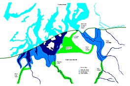
Glacial lakes Lake Puyallup & Early Lake Russell
|
|
| Location | Puget Sound Kitsap County, Washington |
| Coordinates | 47°25′11″N 122°24′53″W / 47.419730°N 122.414608°W |
| Lake type | Glacial lake (former) |
| Primary inflows | Vashon Lobe of the continental glacier |
| Primary outflows | Black Lake Outlet |
| Basin countries | United States |
| Max. length | 65 miles (105 km) |
| Max. width | 54 miles (87 km) |
| Max. depth | 155 m (509 ft) |
| Residence time | ca 600 years |
| Surface elevation | 160 m (520 ft) |
Lake Russell was a huge ancient lake in what is now the Puget Sound area of Washington state. It formed during the Ice Age, specifically during a time called the Vashon Glaciation. This was when a giant sheet of ice, the Cordilleran Ice Cap, covered much of North America.
As the ice melted and moved back, many lakes formed. Lake Russell was the biggest and lasted the longest in the Puget Sound region. Its surface was about 160 ft (49 m) above today's sea level. It drained near Shelton, Washington.
When the ice continued to melt and move north, the lake grew even larger. Its water level then dropped to about 120 ft (37 m) above sea level. This new, lower lake is sometimes called Lake Hood. Lake Russell is named after Isaac Russell, a geologist who studied Earth's history.
This giant lake existed for about 1,000 years. It first appeared around 17,000 years ago and finally disappeared about 15,900 years ago.
How Lake Russell Formed
Early Lake Russell began to form in the southern parts of Puget Sound. As the huge glacier slowly moved northward, it left behind deep valleys. These valleys became blocked by the ice, so water couldn't flow north.
The areas east of Tacoma were separate from the areas to the west. The eastern waters were called Lake Tacoma. They later joined with Lake Russell to the west.
Another lake, Lake Nisqually, formed in the Nisqually Reach. As the ice melted further, the water covered the land between the Nisqually River and Olympia. This connected Lake Nisqually with other freshwater lakes, forming Early Lake Russell.
Lake Russell filled many areas, including the Eld Inlet, Budd Inlet, and Henderson Inlet. It also covered the Nisqually Reach up to the Tacoma Narrows. The water level reached about 160 feet (49 m) above sea level in these areas.
The Black Lake Outlet
When the glacier moved away from the Olympia area, it uncovered a low point in the eastern Black Hills. This low point became the main way for Lake Russell's water to drain.
The water flowed south through the Black River into the Chehalis River valley. There were two main channels for the water. One channel left the Budd Inlet near Butler Cove. Another channel went through Capitol Lake. A third channel might have existed from the Eld Inlet.
These channels joined where Black Lake is today, and the water continued to flow south along the Black River. This path was about 150 to 155 feet (46 to 47 m) above sea level. A wide gravel plain, about 160 feet (49 m) across, formed at the outlet. Scientists believe this gravel was deposited by the strong outflow of water from the lake.
Today, Percival Creek flows through this area. The Northern Pacific Railroad also uses this pass between Puget Sound and the Chehalis Valley. In the pass, there is a long, narrow swamp that drains to both Puget Sound and Grays Harbor. Its elevation is about 120 feet (37 m) above sea level.
Along the southern edge of the pass, there is a large gravel bluff about 150 to 160 feet (46 to 49 m) high. On the northern side, there are gravel terraces at 140 feet (43 m) and 160 feet (49 m). The valley we see today was shaped by water flowing after the Ice Age. The bluffs on both sides show how much the water eroded the land.
Black Lake is located in this pass. It is about 2 to 2.5 miles (3.2 to 4.0 km) long and 0.5 miles (0.80 km) wide. Its surface is about 120 feet (37 m) above sea level.
As the ice moved out of Thurston County, the Deschutes and Nisqually Rivers were able to flow directly north into the growing Lake Russell. The Nisqually River carried a lot of water into Lake Russell. This was because the Ohop channel still brought water from the northern and western slopes of Mount Rainier. This large amount of water helped fill in the ancient river valley, creating the Sherlock Delta.
 | Aaron Henry |
 | T. R. M. Howard |
 | Jesse Jackson |


