Lake Travis facts for kids
Quick facts for kids Lake Travis |
|
|---|---|

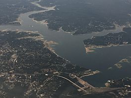
Aerial view of Lake Travis in 2018
|
|
| Location | Travis / Burnet counties, northwest of Austin, Texas |
| Coordinates | 30°23′31″N 97°54′24″W / 30.39194°N 97.90667°W |
| Lake type | Hydroelectric reservoir |
| Primary inflows | Colorado River |
| Primary outflows | Colorado River |
| Basin countries | United States |
| Surface area | 18,930 acres (7,660 ha) |
| Max. depth | 210 ft (64 m) |
| Water volume | 1,130,000 acre⋅ft (1.39 km3) |
| Shore length1 | 270 mi (434 km) |
| Surface elevation | 681 ft (208 m) |
| 1 Shore length is not a well-defined measure. | |
Lake Travis is a large reservoir in central Texas, United States. It was created on the Colorado River.
This lake is mainly used to control floods. Its water level can change a lot, sometimes by almost 100 feet! In 2018, the lake's depth grew by 20 feet in just one day.
Lake Travis covers about 30 square miles. It holds the most water among the seven Highland Lakes. The lake stretches 65 miles (105 km) from western Travis County into southern Burnet County. It reaches all the way to Max Starcke Dam, near Marble Falls.
Besides flood control, Lake Travis also supplies water. It helps generate electricity and is a popular spot for fun activities. The Pedernales River also flows into Lake Travis.
Contents
History of Lake Travis
How Lake Travis Was Made
Lake Travis was formed in 1942. This happened when the Lower Colorado River Authority (LCRA) built Mansfield Dam. The dam is located on the western edge of Austin, Texas.
The lake was built to stop floods. This area often had sudden, strong floods. After a big flood in 1938, the dam was made even taller. This allowed it to hold more floodwaters.
Old Ferry Service
A regular ferry service started in April 1971. It traveled between Point Venture and the south side of Hurst Creek. The trip took 20 minutes. At that time, it was the only inland ferry service in Texas.
Boats Sinking in 2020
On September 5, 2020, several boats sank on Lake Travis. Many boats were moving together, which created very large waves. These waves caused some boats to get into trouble and sink.
Fun Things to Do at Lake Travis
Lake Travis is famous for outdoor activities. People enjoy fishing, boating, swimming, and scuba diving. You can also have picnics, go camping, and even try zip lining.
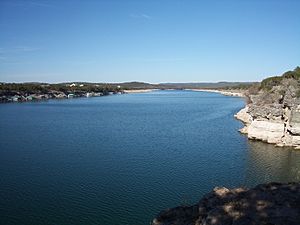
Many people think Lake Travis has some of the clearest water in Texas. It is a very important source of water for Austin and the areas around it.
Fish Living in Lake Travis
Lake Travis has many types of fish. These fish were put there to make fishing better. You can find largemouth bass, guadalupe bass, white bass, and striped bass. There are also catfish and sunfish.
In 2008, some people reported seeing leeches in the lake. Leeches are usually harmless to people. They are mostly just a small bother.
Lake Water Levels
Lake Travis is considered "full" when its water level is at 681 feet (208 meters) above sea level. If the water goes above this level, special floodgates at Mansfield Dam are opened. The U.S. Army Corps of Engineers decides when to open them.
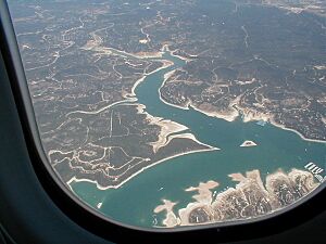
The lake's water level can change a lot. It depends on how much rain falls in the Colorado River basin. The highest the lake has ever been was 710.4 feet (216.5 meters) in December 1991. The lowest was 614.2 feet (187.2 meters) in August 1951.
Dry Spells (Droughts)
During dry periods, called droughts, the lake level drops. In 2008-2009, a very bad drought caused the lake to reach its fourth lowest level. This was 626.09 feet (190.83 meters) in November 2009.
Another drought from 2010 to 2013 made the lake drop to 618 feet (188 meters). This was the third lowest level ever. The LCRA shares updates on the lake's water levels online. In April 2016, the lake finally returned to its full level of 681 feet.
Stopping Floods
Lake Travis is the main lake used to control floods in the Highland Lake chain. The LCRA works with the U.S. Army Corps of Engineers to manage the floodgates at Mansfield Dam.
They open the floodgates carefully after heavy rain. This helps to stop or reduce flooding downstream. Without the dam, floods would be much worse and happen right away. When Lake Travis gets very high during floods, the floodgates are opened to protect homes around the lake and the dam itself.
The dam is built to protect itself during floods. However, if water levels get extremely high, they might have to release a lot of water. This would be done to protect the dam from damage. Even if it causes flooding downstream, protecting the dam is the top priority. The dam can release a huge amount of water, over 130,000 cubic feet per second, which is almost a million gallons per second!
 | Chris Smalls |
 | Fred Hampton |
 | Ralph Abernathy |


