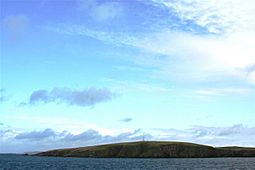
Lamba is a small, empty island in Yell Sound, which is part of the Shetland islands in Scotland. No one lives on Lamba. It sits about 1.5 kilometers (0.9 miles) north of the entrance to Sullom Voe, a long, narrow bay. It's also about 1.4 kilometers (0.9 miles) east of the main Shetland coastline, near a place called Ollaberry.
About Lamba Island
Lamba is 35 meters (115 feet) tall at its highest point. The island covers an area of 43 hectares (0.17 square miles). Even though it's small, Lamba has two important features. One is a tall light, 27 meters (89 feet) high, that helps guide ships safely into Sullom Voe. The other is a communications mast right next to the light. This mast helps send signals, like for phones or internet.
Other Places Named Lamba
It's interesting to know that there are other places with similar names. For example, there's another place called Lamba in the Faroe Islands. There's also Lambay in Ireland.


