
Lambay Island facts for kids
|
Native name:
Reachrainn
|
|
|---|---|
 |
|

Lambay (Island)
Location in island of Ireland

Lambay (Island)
Location in the United Kingdom and Ireland
|
|
| Geography | |
| Location | Irish Sea |
| Coordinates | 53°29′26″N 06°00′54″W / 53.49056°N 6.01500°W |
| Area | 2.5 km2 (0.97 sq mi) |
| Length | 2.7 km (1.68 mi) |
| Width | 2.2 km (1.37 mi) |
| Coastline | 10 km (6 mi) |
| Highest elevation | 126 m (413 ft) |
| Highest point | Knockbane |
| Administration | |
| Province | Leinster |
| County | Dublin |
| Local authority | Fingal County Council |
| Demographics | |
| Population | 7 (2019) |
| Pop. density | 2.4 /km2 (6.2 /sq mi) |
| Additional information | |
| Eircode: K56 KP28 and K56 XK51 | |
Lambay Island, also called Reachrainn in Irish, is a special island in the Irish Sea. It's located off the coast of north County Dublin in Ireland. This island is the biggest one off Ireland's east coast. It sits about 4 kilometers (2.5 miles) from the mainland at Portrane. Lambay is also the easternmost point of the Leinster province.
The island was formed by volcanoes and people have lived there since ancient times. Many studies have been done on its history. Lambay is home to lots of seabirds and other animals, some of which are unique to the island. It also has a group of wallabys! More than 300 types of plants grow here too. The island is owned by a private family trust, the Baring family. Only a few people live there permanently, but some visitors come for day trips or short stays. There's also a working farm on the island.
Contents
What's in a Name?
The name Lambay comes from the word "lamb." This name probably came from the old practice of sending ewes (female sheep) to the island in spring. They would give birth to their lambs there because the island had no predators. This made it a safe place for young lambs.
In Irish, the island is called Reachrainn. The nearby coastal area, Portrane, is known as Port Reachrainn. This means "port of Reachrainn" because it faces the island.
Island Geography
Lambay Island is the largest island off Ireland's east coast. It covers about 2.5 square kilometers (1 square mile). The highest point is a hill called Knockbane, which is 126 meters (413 feet) high. The island's higher areas are mostly in the east. These include Heath Hill, Tinian Hill, and Pilot's Hill.
The northern, eastern, and southern coasts have steep cliffs. The western side, however, has lower land and gentle slopes. Because of the island's shape and weather, most buildings are on the western side. This is where you'll find the Castle, cottages, and the only harbor.
The island has eight named bays and a few narrow inlets. Lambay Head is the easternmost point. Some bays include Talbot's Bay, Carnoon Bay, and Freshwater Bay. There's a sandy beach by the harbor and small rocky areas on the steeper coasts.
Island's Rocks and Water
Lambay Island was formed by volcanoes. Its main rock type is called Lambay Volcanic Formation, which is mostly igneous rocks. The island's bedrock is a mix of andesite (a volcanic rock), tuff (from volcanic ash), and mudstone. There are also layers of shale and limestone, and the soil is loamy.
The island has a few wells, springs, and small streams. These are fed by underground water sources called aquifers. They get refilled by rainfall, so their water levels change with the seasons.
Who Lives on Lambay?
Lambay is one of only five islands off Ireland's eastern coast that are sometimes lived on. The population has changed a lot over time. It has been as high as over 140 people and as low as 3. Here's how the population has changed:
| Historical population | |||||||||||||||||||||||||||||||||||||||||||||||||||||||||||||||||||||||||||||||||||||||||||||||||||
|---|---|---|---|---|---|---|---|---|---|---|---|---|---|---|---|---|---|---|---|---|---|---|---|---|---|---|---|---|---|---|---|---|---|---|---|---|---|---|---|---|---|---|---|---|---|---|---|---|---|---|---|---|---|---|---|---|---|---|---|---|---|---|---|---|---|---|---|---|---|---|---|---|---|---|---|---|---|---|---|---|---|---|---|---|---|---|---|---|---|---|---|---|---|---|---|---|---|---|---|
|
|
|
|
||||||||||||||||||||||||||||||||||||||||||||||||||||||||||||||||||||||||||||||||||||||||||||||||
| Source: (-2011) (2014) (2019) (2020) | |||||||||||||||||||||||||||||||||||||||||||||||||||||||||||||||||||||||||||||||||||||||||||||||||||
Island Rules and Special Status
Lambay Island is part of the townland of Portraine. It falls under the control of Fingal County Council in County Dublin. For voting, it's in the Donabate area.
The island is a very important natural site. It has special protections as a Natura-2000 site. This means it's a Special Protection Area (SPA) for birds and a Special Area of Conservation (SAC) for habitats. It's also part of a larger protected area called the Rockabill to Dalkey Island SAC, which protects reefs and harbour porpoises.
As of 2020, there are 26 official National Monuments on the island. These are important historical sites.
Plants and Animals
When scientists studied Lambay in 1905-1906, they found amazing things. They discovered 90 species (types of living things) that hadn't been seen anywhere else in Ireland. Five of these were completely new to science!
Island Plants
The island is home to 308 different types of plants. However, some of these are "invasive species." These are plants that have come from other places and can sometimes take over, like weeds from farming or gardens.
Island Animals

Lambay has one of the biggest seabird colonies in Ireland. More than 50,000 guillemots, 5,000 kittiwakes, and 3,500 razorbills live here. You can also find puffins, Manx shearwaters, and fulmars.
North Atlantic grey seals come to the island every year to have their pups. The island also has many rabbits. Both brown rats and black rats live here. Lambay is the only place in Ireland with a long-lasting group of black rats.
If you want to see harbour porpoises in County Dublin, Lambay and Rockabill islands are the best spots.
The island also has some rare invertebrates (animals without backbones). The 1905-1906 study found new species of earthworms, a bristletail, and a mite. Scientists noted that the earthworms on the island were smaller than those on the mainland.
Animals from Other Places
You might be surprised to learn that red-necked wallabies live on Lambay! They were first brought to the island in the 1950s by Rupert Baring. More were added from Dublin Zoo in the 1980s. There are now about 100 wallabies. They breed well, so sometimes their numbers need to be managed.
Fallow deer were also brought to the island. By the mid-2000s, there was a herd of about 200. There are also cows and sheep on the island's farm.
Island History
Ancient Times
Lambay Island was very important during the Neolithic period (New Stone Age) in Ireland. People used it as a quarry to get stone for making axes. They used a special type of rock called Lambay porphyry. This site is unique in Ireland because it shows all the steps of axe making, from digging up the rock to polishing the final axe.
In the 1st century CE, the Roman writer Pliny knew about the island. He called it Limnus or Limni. In 1927, some Iron Age burials were found on the island. These included Roman-British items. This suggests that a small group of people might have come to Lambay to escape the Romans around 71 to 74 CE.
Early Middle Ages
It's believed that St. Columba started a monastery on Lambay around 530 AD. This religious settlement was attacked by Vikings in 795. The church and buildings were robbed and burned.
Later Middle Ages
Later, a Danish King of Dublin named Sitric gave Lambay to Christ Church Cathedral. In 1181, Prince John gave it to the Archbishops of Dublin. The island's rents were later given to nuns for their school. The nuns also received taxes from the island's rabbits, which were quite valuable!
In 1467, a plan was made for the Earl of Worcester to build a fortress on Lambay. This was meant to protect England from other countries. It's not clear if the fortress was ever built.
Early Modern Times
During the English Reformation in the 16th century, the Archbishop of Dublin gave Lambay to John Challoner. He was the first Secretary of State for Ireland. Challoner was supposed to build a village, castle, and harbor. He also worked four mines for silver and copper and raised falcons on the cliffs. During this time, Lambay Castle was built on the western side of the island.
The island stayed with the Ussher family for 200 years. James Ussher, a famous Archbishop, lived there in 1626. During the Williamite war in Ireland, over a thousand Irish soldiers were held prisoner on the island after the Battle of Aughrim in 1691. Many died from wounds and hunger.
Georgian and Victorian Eras


In 1814, the aristocratic Talbot family of Malahide bought Lambay. They built a Catholic chapel and a school on the island.
A famous shipwreck happened near Lambay on January 21, 1854. The ship, the RMS Tayleur, was on its first trip from Liverpool to Perth, Australia. It hit the island's rocks and sank. Out of 650 people, mostly families moving to Australia, 380 lives were lost. The crew thought they were sailing south, but problems with the compass made them go west. Many crew members also spoke Chinese and couldn't understand the English officers well.
In 1860, the Talbot family removed the farmers to make the island a hunting ground. Later, new tenants came. In 1888, Count James Consedine bought Lambay to make it a hunting retreat.
The Baring Family Takes Over
In 1904, Cecil Baring bought Lambay. He was a member of the Baring banking family. He bought the island for himself and his new wife, Maude, the daughter of a tobacco millionaire.
The island's main house was in bad shape. So, Cecil hired a famous architect, Sir Edwin Lutyens, to fix it up. Lutyens rebuilt and added to the house in the Arts and Crafts style. He also designed a circular wall around the castle and its garden. This wall helps block the wind, allowing plants to grow inside.
Cecil Baring lived on the island until he died in 1934. He and his wife Maude are buried in a family tomb on Lambay. Rupert Baring, Cecil's son, managed the island from 1934 to 1994. He set up a family trust to keep the island for his relatives.
Today, Rupert's son, Alexander "Alex" Rupert, manages the island with his half-sister Millie Baring.
New Plans for the Island
Around 2011, a new plan was made for the island. This included changes to the castle, which only had one working toilet at the time! The plans included adding bathrooms, a modern heating system, and new water systems. They also planned for a new wind turbine and solar panels to help with electricity. The island's electricity was very limited, only enough for basic lights and a washing machine.
In 2015, a special club was started to support the island. A whiskey project also began. In 2018, Prince Edward visited the island.
Lambay Island Whiskey
A special company was created for the whiskey project in 2017. It's a partnership between the island's owners and the Camus Cognac family. The whiskey is made in Ireland, but water from Lambay's Trinity Well is added. Some batches are even aged on the island. Lambay Island Whiskey was launched in 2018. The company is now planning to build a small distillery on the island to make whiskey and gin.
Digging Up the Past (Archaeology)
Scientists have studied the history of Lambay Island many times. From 1993 to 2001, they found a stone axe factory near the center of the island. This factory used the special Lambay porphyry rock. They also found ancient pottery and flint.
Many human burial sites have been discovered on the island. The remains of at least two ancient forts have also been found.
Shipwrecks Around Lambay
There are about fifty shipwrecks in the waters around Lambay. The RMS Tayleur, which sank in 1854, is the most popular for scuba divers. However, you need a special license to dive there because the wreck is over 100 years old.
Another interesting wreck is The Shamrock, which sank in 1916. This ship was carrying dangerous phosphorus shells and explosives. Steps were cut into the nearby rock to help remove these items.
Island Religion
It's said that St Columba started a monastery on Lambay in the 6th century. This monastery lasted for over 200 years. It was attacked by Vikings in 795, which was the first recorded Viking attack on Ireland.
In 1833, a new Catholic chapel was built on the island. The Talbot family, who owned the island, helped pay for it. The chapel was later changed by Edwin Lutyens in the 1910s. The Baring family and other island residents still attend services there on Sundays.
Island Buildings
Lambay Castle

Lambay Castle was originally a small fort from the late 1500s. Sir Edwin Lutyens turned it into a beautiful castle for Cecil Baring. Cecil bought the island in 1904 as a special place for himself and his new wife, Maude.
Lutyens made the old fort livable and added a new section with kitchens, bathrooms, and bedrooms. He also built a circular wall around the castle and its garden. This wall acts as a windbreak, helping plants grow inside. The castle rooms have arched ceilings and stone fireplaces.
The White House
Near the harbor is a house called the White House. Lutyens designed it in the 1930s for Lord Revelstoke's daughters and their families. It has high roofs and white walls.
Coastguard Cottages
A row of small cottages, once used by guards, are also near the harbor. Some of these are available to rent today.
Harbor and Entrance
Lutyens also designed the way you approach the island from the harbor. He created curved, step-like terraces. These designs make the entrance feel welcoming.
The Chapel
On a small cliff near the White House is a 19th-century Catholic chapel. Lutyens added stone columns to its entrance. Inside, you can see religious symbols and art made by family members.
Old School Building
There was once a school building within the castle grounds. In the 1840s, about 40 children were enrolled there.
Life on Lambay Today
Lambay Island is still privately owned by the Revelstoke Trust, which is a family trust. Alex and Brooke Baring and their children are the main permanent residents. A small staff also lives there.
The island has a working farm with Galloway cows and sheep. The farm uses organic methods, meaning no pesticides or chemicals. It tries to disturb the native plants and animals as little as possible. The farm also works with the island's fallow deer and wallabies.
Island Power
Lambay Island does not have power or communication cables from the mainland. About 75% of its energy comes from solar panels. A wind turbine helps too, and there's a backup generator.
Visiting Lambay
The island is usually only accessible by invitation. Most visitors come from the marina at Malahide. There's also a small airstrip for light airplanes and places for helicopters to land.
You can rent a cottage on the island, and the White House is available for larger groups or special events.
The Island Club
Around 2015, a supporters club was started for people who care about the island's history and wildlife. Members can enjoy "think ins" and "off grid breaks" away from busy city life.
Fun and Sports
Real Tennis
There is a real tennis court near the harbor. It was built in 1922 and is one of only two left in Ireland. It's the only one you can visit.
Island Tours
While you can't just show up, groups interested in gardening, architecture, and birds can arrange visits. Walking tours are also offered by a local boatman.
Water Sports
The deep waters around the island attract scuba divers and fishermen. People also catch lobsters there.
Other Activities
There used to be a lawn tennis court and a small golf course.
In 1921, the winners of the Gordon Bennett Gas Balloon Race landed on Lambay. Captains Paul Armbruster and Louis Ansermier from Switzerland flew over 756 kilometers (470 miles) from Brussels, Belgium, for more than 27 hours!
Images for kids
-
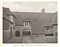
The new Kitchen Court, from Weaver(1913)

See also
 In Spanish: Isla de Lambay para niños
