
Lampang province facts for kids
Quick facts for kids
Lampang
ลำปาง
ᩃᩣᩴᨻᩣ᩠ᨦ
|
|||
|---|---|---|---|
| จังหวัดลำปาง · ᨧᩢ᩠ᨦᩉ᩠ᩅᩢᨯᩃᩣᩴᨻᩣ᩠ᨦ | |||
|
From left to right, top to bottom : Wat Phra That Lampang Luang, Chae Son National Park, Wat Sri Chum, Wat Phra Kaeo Don Tao, Wang River, The Thai Elephant Conservation Center
|
|||
|
|||
| Nickname(s):
Khelang Nakhon
Kukuta Nakhon (white rooster city) Mueang Rot Ma (horse carriage city) |
|||

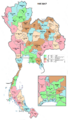
Map of Thailand highlighting Lampang province
|
|||
| Country | Thailand | ||
| Capital | Lampang | ||
| Area | |||
| • Total | 12,488 km2 (4,822 sq mi) | ||
| Area rank | Ranked 9th | ||
| Population
(2019)
|
|||
| • Total | 738,316 | ||
| • Rank | Ranked 33rd | ||
| • Density | 59/km2 (150/sq mi) | ||
| • Density rank | Ranked 70th | ||
| Human Achievement Index | |||
| • HAI (2017) | 0.6450 "high" Ranked 9th |
||
| Time zone | UTC+7 (ICT) | ||
| Postal code |
52xxx
|
||
| Calling code | 054 | ||
| ISO 3166 code | TH-52 | ||
| Vehicle registration | ลำปาง | ||


.jpg)


Lampang (Thai: ลำปาง) is one of Thailand's 76 provinces. It is located in the upper northern part of Thailand. The old name for Lampang was Khelang Nakhon.
| Lampang province | |
|---|---|

"Lampang" in Thai language (top) and
Northern Thai with Tai Tham script (bottom) |
|
| Thai name | |
| Thai | ลำปาง |
| RTGS | Lampang |
| Northern Thai name | |
| Northern Thai | ᩃᩣᩴᨻᩣ᩠ᨦ (Lam phuang) |
Contents
Geography of Lampang Province
Lampang is in a wide valley of the Wang River. Mountains surround the area. In Mae Mo district, a type of coal called lignite is found and dug up from open pits. To the north, you'll find Doi Luang, a mountain that is about 1,697 meters (5,568 feet) high.
Lampang province is home to several national parks. These include Chae Son and Doi Khun Tan National Park in the Khun Tan Range. You can also find Tham Pha Thai, Doi Luang National Park, and the Huai Tak Teak Biosphere Reserve in the Phi Pan Nam Range. About 70 percent of the province is covered by forests.
National Parks to Explore
Lampang province has eight national parks. Six of these are managed by the Lampang branch of Thailand's protected areas. The other two are Doi Luang and Wiang Kosai.
- Tham Pha Tai National Park (1,200 km²)
- Doi Luang National Park (1,169 km²)
- Mae Wa National Park (582 km²)
- Wiang Kosai national Park (410 km²)
- Doi Chong National Park (336 km²)
- Chae Son National Park (297 km²)
- Doi Khun Tan National Park (255 km²)
- Khelang Banphot National Park (80 km²)
Wildlife Sanctuaries
There are two wildlife sanctuaries in Lampang. These are special areas that protect animals and their homes.
- Doi Pha Muang Wildlife Sanctuary (687 km²)
- Tham Chao Ram Wildlife Sanctuary (341 km²)
History of Lampang
Lampang was part of the Hariphunchai Kingdom, ruled by the Mon, starting in the 7th century. Later, in the 11th century, the Khmer Empire took over the area.
In 1292, King Mengrai of Lanna made Lampang part of his kingdom. From the 16th to the 18th century, Lampang was under Burmese rule. This changed when new kings in Siam (now Thailand) fought against Burmese rule in the late 1700s. A local leader from Lampang helped Siam. After Siam won, this leader, Kawila, became the ruler of Chiang Mai. His relative then ruled Lampang.
Lampang continued to be an important city in northern Thailand. It officially became a province of Thailand in 1892.
Getting Around Lampang
Lampang is a key place for roads. It has a four-lane highway that connects to Chiang Mai and Chiang Rai. There's also a major highway to Phrae and other eastern Lanna provinces. A bus ride from Lampang to Chiang Mai takes about 1.5 hours.
You can also travel to Lampang by train. It's a stop for trains going to Chiang Mai, and the journey from Bangkok takes about 10 hours.
Lampang Airport has flights from Bangkok. Bangkok Airways flies to Suvarnabhumi Airport, and Nok Air flies to Don Mueang.
Health Services
The main hospital in Lampang is Lampang Hospital. It is run by the Ministry of Public Health.
Tourism in Lampang
Lampang province is not as well-known to tourists as some other places in Thailand. About 900,000 visitors come each year, but most just pass through. In early 2019, the provincial governor started a plan called "Lampang: Dream Destination." The goal is to attract two million visitors within two years.
Economy and Industry

Lampang is famous for making ceramic goods and for its mining. A lot of ball clay, china stone, and lignite (a type of coal) are dug up from the mountains nearby.
There are over 200 ceramic factories in and around Mueang Lampang District. These factories make many things, like plant pots, dolls, dishes, and building materials such as tiles.
The biggest coal-fired power plant in Southeast Asia is in Mae Mo District. It uses lignite from the local mines to make electricity. The largest concrete plant is also north of Mueang Lampang and uses lignite for power. Limestone is another common rock mined in Lampang.
For farming, Lampang province grows rice and pineapples.
Symbols of Lampang
The provincial seal of Lampang shows a white rooster. This rooster is standing inside the entrance to the Phra That Lampang Luang Temple. A local story says that Buddha once visited Lampang. The god Indra was worried people wouldn't wake up to show respect to Buddha. So, Indra turned into a white rooster to wake everyone up.
The provincial flower is the Heliconia (Heliconia sp.). The provincial tree is the Indian Elm (Holoptelea integrifolia). Legend says this tree was planted at the temple during Buddha's visit.
How Lampang is Governed

Lampang province is divided into 13 main areas called districts (amphoes). These districts are then split into 100 smaller areas called subdistricts (tambons), and these have 855 villages (mubans).
Districts of Lampang
- Mueang Lampang
- Mae Mo
- Ko Kha
- Soem Ngam
- Ngao
- Chae Hom
- Wang Nuea
- Thoen
- Mae Phrik
- Mae Tha
- Sop Prap
- Hang Chat
- Mueang Pan
Local Government
As of November 26, 2019, Lampang has one main provincial administration group. It also has 42 municipal areas. Lampang city itself has "city" status. Other towns like Khelang Nakhon, Lom Raet, and Phichai have "town" status. There are also 38 smaller subdistrict municipalities. Areas not covered by municipalities are managed by 60 Subdistrict Administrative Organizations.
Human Achievement Index 2017
The Human Achievement Index (HAI) measures how well people are doing in different areas of life. Since 2003, the United Nations Development Programme (UNDP) in Thailand has used this index to track human development in different provinces. The National Economic and Social Development Board (NESDB) took over this job in 2017.
Lampang province has an HAI value of 0.6450, which is considered "high." This means Lampang ranks 9th among all provinces in Thailand for human development in 2017.
Images for kids
-
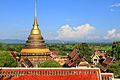
Wat Phra That Lampang Luang
-
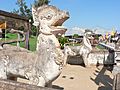
Singha Lanna
-
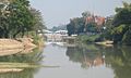
Wang River
-
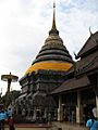
Phra That Lampang Luang
-
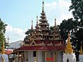
Burmese-style Wat Srichum
-

Chae Son National Park
-

Hot springs at Chae Son National Park
-

Health
-

Education
-

Employment
-

Income
-

Housing
-

Family
-

Transport
-

Participation
-
Map with provinces and HAI 2017 rankings


.png)

See also
 In Spanish: Provincia de Lampang para niños
