Landrum, South Carolina facts for kids
Quick facts for kids
Landrum, South Carolina
|
|
|---|---|

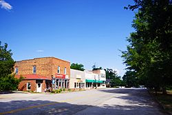
Trade Avenue (S-562)
|
|

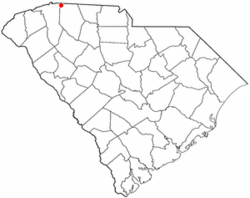
Location of Landrum, South Carolina
|
|
| Country | United States |
| State | South Carolina |
| County | Spartanburg |
| Area | |
| • Total | 2.65 sq mi (6.87 km2) |
| • Land | 2.65 sq mi (6.85 km2) |
| • Water | 0.01 sq mi (0.02 km2) |
| Elevation | 1,047 ft (319 m) |
| Population
(2020)
|
|
| • Total | 2,481 |
| • Density | 938.00/sq mi (362.11/km2) |
| Time zone | UTC-5 (Eastern (EST)) |
| • Summer (DST) | UTC-4 (EDT) |
| ZIP code |
29356
|
| Area codes | 864, 821 |
| FIPS code | 45-40075 |
| GNIS feature ID | 1246289 |
| Website | http://cityoflandrumsc.com |
Landrum is a city in Spartanburg County, South Carolina, United States. In 2020, about 2,481 people lived there.
The city of Landrum was started in 1880. It became an official town in 1912. Landrum is located near Interstate 26. It sits between the cities of Spartanburg and Asheville, North Carolina.
Contents
Landrum's Early History
The area where Landrum is today was first settled around 1760. Early settlers came from states like Pennsylvania, Maryland, and Virginia. They built a fort about two miles from where the city now stands.
The town of Landrum officially began in 1880. This happened after a railroad line was built north from Spartanburg. The town was named after John Gill Landrum. He donated the land for the local train station. Landrum became a town three years later. In 1973, it was changed to a city.
Where is Landrum Located?
Landrum is located at coordinates 35.175326 degrees north and -82.186036 degrees west. The city is mainly found where two main roads meet: U.S. Route 176 and South Carolina Highway 14. It is just south of the border between North Carolina and South Carolina.
The United States Census Bureau says that Landrum covers about 2.3 square miles. Only a very small part of this area, about 0.43%, is water.
Landrum's Population Over Time
Landrum has grown quite a bit since it was first settled. Here's how its population has changed:
- 1890: 155 people
- 1900: 263 people
- 1910: 449 people
- 1920: 980 people
- 1930: 1,212 people
- 1940: 1,289 people
- 1950: 1,333 people
- 1960: 1,930 people
- 1970: 1,859 people
- 1980: 2,141 people
- 1990: 2,347 people
- 2000: 2,472 people
- 2010: 2,376 people
- 2020: 2,481 people
Who Lives in Landrum? (2020 Census)
The 2020 United States census counted 2,481 people living in Landrum. There were 1,125 households and 632 families.
Here is a look at the different groups of people living in Landrum:
- White (not Hispanic): 82.59%
- Black or African American (not Hispanic): 9.07%
- Native American: 0.04%
- Asian: 0.44%
- Other or Mixed Race: 3.71%
- Hispanic or Latino: 4.15%
Schools and Learning in Landrum
Landrum has several schools for students of all ages.
Public Schools
- O.P. Earle Elementary: This school serves students from pre-kindergarten to 5th grade.
- Landrum Middle School: Students in 5th through 8th grade attend this school.
- Landrum High School: This school is for older students, from 9th to 12th grade.
Private Schools
- Grace Christian School: This is a private school that teaches students from pre-kindergarten all the way through 12th grade.
Public Library
Landrum also has a public library. It is a part of the Spartanburg County Public Library system. This library lets people borrow books and other materials for free.
See also
 In Spanish: Landrum (Carolina del Sur) para niños
 | William M. Jackson |
 | Juan E. Gilbert |
 | Neil deGrasse Tyson |

