Largo, Maryland facts for kids
Quick facts for kids
Largo, Maryland
|
|
|---|---|

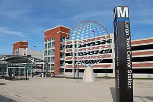
Downtown Largo station in Downtown Largo
|
|

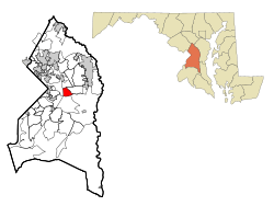
Location of Largo, Maryland
|
|
| Country | |
| State | |
| County | |
| Named for | Largo Bay, Scotland |
| Area | |
| • Total | 3.06 sq mi (7.93 km2) |
| • Land | 3.06 sq mi (7.93 km2) |
| • Water | 0.00 sq mi (0.00 km2) |
| Elevation | 174 ft (53 m) |
| Population
(2020)
|
|
| • Total | 11,605 |
| • Density | 3,790.01/sq mi (1,463.43/km2) |
| Time zone | UTC−5 (Eastern (EST)) |
| • Summer (DST) | UTC−4 (EDT) |
| ZIP code |
20774
|
| Area code(s) | 301, 240 |
| FIPS code | 24-45825 |
| GNIS feature ID | 0597664 |
Largo is a community in Prince George's County, Maryland, United States. It's not an official city, but a "census-designated place" (CDP). This means it's an area the government uses for gathering population data. In 2020, about 11,605 people lived here.
Largo is located just east of the Capital Beltway (I-95/495), which is a major highway loop around Washington D.C. It is home to Prince George's Community College and Largo High School.
You can find fun places nearby, like Six Flags America amusement park. It's just to the east in Woodmore. Also, FedExField, where the Washington Commanders football team plays, is across the Capital Beltway. Watkins Regional Park is also close by. It has an old-fashioned carousel, a miniature train, mini-golf, and even a farm with animals!
Largo is also important for transportation. The Downtown Largo station is the eastern end of the Blue and Silver Lines of the Washington Metro subway system. This makes it easy to travel to and from Largo.
Contents
History of Largo
Largo got its name from the Largo Plantation. This plantation was owned by the Beall family a long time ago. People believe it was named after Largo Bay in Scotland. The plantation was sold to John Contee in 1745.
For many years, people have talked about moving the main government offices for Prince George's County to Largo. In 2015, the county executive, Rushern Baker, thought it was a good idea. He believed Largo was a better spot because it's more central and has easy access to the Washington Metro subway. However, not everyone agreed with this plan.
Getting Around: Transportation in Largo
Largo is a key spot for public transportation. The Downtown Largo station is the final stop for the Blue and Silver Lines of the Washington Metro subway system. This station also serves many bus routes. These buses are run by WMATA (Washington Area Transit Authority) and Prince George's County's own "The Bus" service. This makes it simple for people to travel within Largo and to other nearby areas.
Largo's Location: Geography
Largo is located at coordinates 38°52′37″N 76°49′50″W. It covers an area of about 3.0 square miles (7.93 square kilometers). All of this area is land, with no large bodies of water within its boundaries.
Who Lives in Largo: Demographics
The population of Largo has changed over the years. Here's a look at the racial and ethnic makeup of the community based on the 2010 and 2020 U.S. Census data.
| Race / Ethnicity (NH = Non-Hispanic) | Pop 2010 | Pop 2020 | % 2010 | % 2020 |
|---|---|---|---|---|
| White alone (NH) | 309 | 232 | 2.89% | 2.00% |
| Black or African American alone (NH) | 9,691 | 10,134 | 90.49% | 87.32% |
| Native American or Alaska Native alone (NH) | 31 | 25 | 0.29% | 0.22% |
| Asian alone (NH) | 194 | 189 | 1.81% | 1.63% |
| Pacific Islander alone (NH) | 0 | 1 | 0.00% | 0.01% |
| Some Other Race alone (NH) | 15 | 68 | 0.14% | 0.59% |
| Mixed Race or Multi-Racial (NH) | 192 | 421 | 1.79% | 3.63% |
| Hispanic or Latino (any race) | 277 | 535 | 2.59% | 4.61% |
| Total | 10,709 | 11,605 | 100.00% | 100.00% |
Learning in Largo: Education
Largo has several schools for students of all ages.
Schools for Kids and Teens
Largo is part of the Prince George's County Public Schools system. Younger students in Largo attend one of three elementary schools: Arrowhead, Kettering, or Lake Arbor. Most middle school students go to Kettering Middle School, while some attend Ernest Everett Just Middle School. All high school students in Largo attend Largo High School.
There is also a private school called Divine Peace Lutheran School. It is a Christian school for students from kindergarten through 8th grade.
College Education
Largo is home to Prince George's Community College. This college serves the entire county, which has a population of about 850,000 people. It offers many different programs for students who want to continue their education after high school.
Public Libraries
Largo has a public library branch called the Largo-Kettering Branch. It is part of the Prince George's County Memorial Library System (PGCMLS). This branch is also special because it is the main headquarters for the entire library system! The headquarters moved to Largo in 2015.
Famous People from Largo
Many talented people have come from Largo, Maryland, including:
- Wale Folarin, a rapper
- Usama Young, a former American football safety
- Oddisee, a rapper
- Albert Wynn, a former Congressman
- Q Da Fool, a rapper
- Rico Nasty, a rapper
- Tramell Tillman, an actor
- redveil, a rapper
See also
 In Spanish: Largo (Maryland) para niños
 | Chris Smalls |
 | Fred Hampton |
 | Ralph Abernathy |


