Lathe of Sutton at Hone facts for kids
| Sutton at Hone | |
| Geography | |
| Status | obsolete |
| History | |
| Origin | Jutish Kent |
| Created | 6th century |
| Abolished | 1894 (obsolete) |
| Succeeded by | diverse authorities |
Quick facts for kids Politics |
|
|---|---|
| Governance | Lathe |
| Subdivisions | |
| Type | Hundreds |
| Units | Blackheath, Bromley and Beckenham, Ruxley, Little and Lesnes, Dartford and Wilmington, Axstane, Codsheath, Wistram (later Westerham and Edenbridge), Somerden |
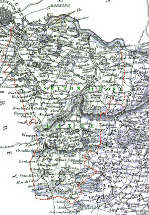
Have you ever wondered how places were organized long ago? The Lathe of Sutton-at-Hone was a very old way of dividing up land in Kent, England. It was like a big district that included many areas we know today. These areas are now parts of Dartford, Bexley, Greenwich, Bromley, Lewisham, and the Sevenoaks District. It even covered small bits of the Borough of Tonbridge and Malling and Borough of Tunbridge Wells.
This important area was named after the small village and parish of Sutton at Hone. This village is located in the beautiful Darent valley.
What Was a Lathe?
A Lathe was a very old administrative division in Kent. Think of it like a super-county! These divisions likely started around the 6th century AD. This was when the Jutes, an ancient Germanic people, began settling in Kent.
It was common for Anglo-Saxons to set up their legal and administrative centers a bit away from bigger towns. Sutton at Hone is about two miles from Dartford. Dartford was one of only four royal manors in Kent during the time of the Domesday Book.
Early Days of the Lathe
During the Domesday Book period, Sutton was known as a "Half Lathe." There was another "Half Lathe" called Milton. At that time, Kent also had five "full" Lathes: Aylesford, Borough, Eastry, Lympne (later called Shepway), and Wye.
By the year 1295, Sutton had grown in importance. It was then promoted to a full Lathe! At this point, there were only four other Lathes left. This happened because some of the older Lathes had merged. For example, Borough and Eastry joined to form the Lathe of Saint Augustine. Milton and Wye combined to create the Lathe of Scray.
How the Lathe Was Used
The Lathe of Sutton-at-Hone remained a key part of local government for 600 years after the Domesday Book. It helped with administration, legal matters, and collecting taxes. Lathes were much larger than "hundreds," which were smaller local divisions.
Even though it was never officially ended, the Lathe stopped having administrative duties by the late 1800s. The Sheriff, a high-ranking official, used to visit each Lathe twice a year. For Sutton, these visits might have happened at Shire Hall. The Lathe was also responsible for gathering money and support for the local Militia (a group of citizens who could be called upon to defend the area).
The Lathe of Sutton was even mentioned in The London Gazette as late as 1899. This shows how long it remained a recognized part of the region's history.
Areas Within the Lathe
According to a historian named Hasted, the Lathe of Sutton at Hone was made up of several smaller areas called Hundreds. These included:
- Blackheath
- Ruxley
- Bromley and Beckenham
- Little and Lesnes
- Dartford and Wilmington
- Axstane
- Codsheath
- Westerham and Edenbridge
- Somerden
The Lathe of Sutton was the most western of all the Lathes in Kent. The first four Hundreds listed above now form parts of the London boroughs of Lewisham, Greenwich, Bexley, and Bromley. However, Penge was not originally part of Kent.
Dartford and Wilmington Hundred is now part of the Dartford borough. Axstane Hundred is split between the Dartford and Sevenoaks districts. The last three Hundreds (Codsheath, Westerham and Edenbridge, and Somerden) make up the rest of the Sevenoaks District. Interestingly, Somerden, and therefore the Lathe of Sutton, included a part of Speldhurst parish, which is now in Royal Tunbridge Wells.
This means that the old boundary of the Lathe is still quite similar to the current borders of the Dartford and Sevenoaks local authorities with the rest of Kent. The Lathe of Sutton covered a large area, about 173,440 acres. That's about 271 square miles or 702 square kilometers!
 | Sharif Bey |
 | Hale Woodruff |
 | Richmond Barthé |
 | Purvis Young |


