Lathrop, Missouri facts for kids
Quick facts for kids
Lathrop, Missouri
|
|
|---|---|
| Nickname(s):
The Mule Capital of the World
|
|

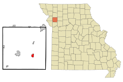
Location of Lathrop, Missouri
|
|
| Country | United States |
| State | Missouri |
| County | Clinton |
| Area | |
| • Total | 4.19 sq mi (10.86 km2) |
| • Land | 4.19 sq mi (10.86 km2) |
| • Water | 0.00 sq mi (0.00 km2) |
| Elevation | 1,043 ft (318 m) |
| Population
(2020)
|
|
| • Total | 2,271 |
| • Density | 541.62/sq mi (209.10/km2) |
| Time zone | UTC-6 (Central (CST)) |
| • Summer (DST) | UTC-5 (CDT) |
| ZIP code |
64465
|
| Area code(s) | 816 |
| FIPS code | 29-40826 |
| GNIS feature ID | 2395639 |
| Website | http://www.cityoflathropmo.com |
Lathrop is a city located in Clinton County, Missouri. It is part of the larger Kansas City metropolitan area in the United States. In 2020, about 2,271 people lived there.
Contents
History of Lathrop
Lathrop was officially started in 1867. It was planned as a stop for the Cameron Cutoff Branch of the Hannibal and St. Joseph Railroad. The city got its name from John L. Lathrop, who was the treasurer for the railroad company. A post office has been open in Lathrop since 1868.
The Mule Capital of the World
In the early 1900s, Lathrop became known as the "Mule Capital of the World." This happened because of a company called Guyton and Harrington. They sold a huge number of mules and horses. During World War I, they sold 180,000 mules and 170,000 horses to the British Army.
The cousins J.D. Guyton and W.R. Harrington owned a very large area of land, about 4,700 acres, near Lathrop. They also supplied mules to the British during the Boer War. Their facilities in Lathrop were impressive. They had three barns, each big enough for 1,000 mules. There was also a very long hay barn, measuring 496 feet!
The British Army even had a special contract for a remount station in Lathrop. This was a place where they could get fresh animals. The mule business slowed down a lot in the 1920s. Today, you can still see the town's history with mules. Some businesses in Lathrop have "mule" in their name, like The Mule Stop. A road east of town is even called Mule Barn Road. The local high school team's mascot is also the mules!
Geography of Lathrop
Lathrop is located where two Missouri roads, Route 33 and Route 116, meet. It is about three miles west of I-35 and nine miles east of Plattsburg.
The city covers a total area of about 1.79 square miles (4.64 square kilometers). All of this area is land.
Population and People
| Historical population | |||
|---|---|---|---|
| Census | Pop. | %± | |
| 1870 | 523 | — | |
| 1880 | 746 | 42.6% | |
| 1890 | 1,082 | 45.0% | |
| 1900 | 1,118 | 3.3% | |
| 1910 | 1,038 | −7.2% | |
| 1920 | 1,100 | 6.0% | |
| 1930 | 940 | −14.5% | |
| 1940 | 1,049 | 11.6% | |
| 1950 | 888 | −15.3% | |
| 1960 | 1,006 | 13.3% | |
| 1970 | 1,268 | 26.0% | |
| 1980 | 1,732 | 36.6% | |
| 1990 | 1,794 | 3.6% | |
| 2000 | 2,092 | 16.6% | |
| 2010 | 2,086 | −0.3% | |
| 2020 | 2,271 | 8.9% | |
| U.S. Decennial Census | |||
Lathrop's Population in 2010
In 2010, there were 2,086 people living in Lathrop. The city had 794 households, with 574 of them being families. About 40% of the households had children under 18 living there. The average age of people in the city was 34 years old. About 28.5% of the residents were under 18.
Lathrop High School
Lathrop High School has about 297 students. There is one teacher for every 14 students. The school's sports teams have been very successful, especially in the 2017-2018 and 2018-2019 school years. People in Lathrop are very proud of their school's athletic programs.
References
See also
In Spanish: Lathrop (Misuri) para niños
 | Georgia Louise Harris Brown |
 | Julian Abele |
 | Norma Merrick Sklarek |
 | William Sidney Pittman |

