
Laupāhoehoe, Hawaii facts for kids
Quick facts for kids
Laupāhoehoe, Hawaii
|
|
|---|---|

Tsunami memorial at Laupāhoehoe Point
|
|

Location in Hawaiʻi County and the state of Hawaii
|
|
| Country | United States |
| State | Hawaii |
| County | Hawaiʻi |
| Area | |
| • Total | 3.49 sq mi (9.05 km2) |
| • Land | 3.24 sq mi (8.39 km2) |
| • Water | 0.25 sq mi (0.66 km2) |
| Elevation | 360 ft (110 m) |
| Population
(2020)
|
|
| • Total | 1,147 |
| • Density | 353.90/sq mi (136.64/km2) |
| Time zone | UTC-10 (Hawaii-Aleutian) |
| ZIP code |
96764
|
| Area code(s) | 808 |
| FIPS code | 15-44150 |
| GNIS feature ID | 0361749 |
Laupāhoehoe is a small community located on the northeast side of the Big Island in Hawaii. It's known as a "census-designated place" (CDP), which means it's a special area defined for counting people by the government. The name Laupāhoehoe means "lava tip." This name comes from the unique shape of the land, which was formed by ancient, smooth lava flows.
Contents
History of Laupāhoehoe
The most significant event in Laupāhoehoe's history happened on April 1, 1946. On this day, a huge tsunami (a giant ocean wave caused by an earthquake) hit the Hawaiian Islands. This tsunami was caused by a powerful earthquake far away in the Aleutian Islands.
About 159 people across the islands lost their lives. The Big Island was hit the hardest. In Laupāhoehoe, the local school building was completely covered by the tsunami. Tragically, 24 people drowned there. This included 16 schoolchildren, four teachers, and four local residents. Today, a special monument stands at Laupāhoehoe Point to remember those who died.
Geography of Laupāhoehoe
Laupāhoehoe is found on the northeast side of the island of Hawaii. Its exact location is 19°59′5″N 155°14′10″W / 19.98472°N 155.23611°W. Hawaii Route 19 runs through the community. This road goes southeast about 24 miles (39 km) to Hilo and west about 32 miles (51 km) to Waimea.
According to the United States Census Bureau, the total area of this community is about 6.2 square kilometers (2.4 square miles). Most of this area, about 5.5 square kilometers (2.1 square miles), is land. The rest, about 0.7 square kilometers (0.27 square miles), is water.
Climate in Laupāhoehoe
| Climate data for Kīhālani, Hawaii, 1991–2020 normals, extremes 1998–2014 | |||||||||||||
|---|---|---|---|---|---|---|---|---|---|---|---|---|---|
| Month | Jan | Feb | Mar | Apr | May | Jun | Jul | Aug | Sep | Oct | Nov | Dec | Year |
| Record high °F (°C) | 85 (29) |
86 (30) |
89 (32) |
84 (29) |
88 (31) |
86 (30) |
85 (29) |
88 (31) |
88 (31) |
87 (31) |
86 (30) |
85 (29) |
89 (32) |
| Mean daily maximum °F (°C) | 76.1 (24.5) |
75.5 (24.2) |
76.1 (24.5) |
77.1 (25.1) |
78.1 (25.6) |
79.3 (26.3) |
79.9 (26.6) |
81.1 (27.3) |
81.3 (27.4) |
80.4 (26.9) |
78.2 (25.7) |
76.2 (24.6) |
78.3 (25.7) |
| Daily mean °F (°C) | 68.7 (20.4) |
68.4 (20.2) |
69.1 (20.6) |
70.0 (21.1) |
71.5 (21.9) |
72.4 (22.4) |
73.3 (22.9) |
74.1 (23.4) |
73.9 (23.3) |
73.4 (23.0) |
71.7 (22.1) |
69.8 (21.0) |
71.4 (21.9) |
| Mean daily minimum °F (°C) | 61.4 (16.3) |
61.3 (16.3) |
62.1 (16.7) |
63.0 (17.2) |
65.0 (18.3) |
65.6 (18.7) |
66.6 (19.2) |
67.1 (19.5) |
66.5 (19.2) |
66.5 (19.2) |
65.2 (18.4) |
63.4 (17.4) |
64.5 (18.0) |
| Record low °F (°C) | 55 (13) |
56 (13) |
55 (13) |
55 (13) |
58 (14) |
60 (16) |
61 (16) |
60 (16) |
61 (16) |
61 (16) |
58 (14) |
57 (14) |
55 (13) |
| Average precipitation inches (mm) | 10.39 (264) |
12.64 (321) |
17.34 (440) |
14.57 (370) |
7.79 (198) |
6.50 (165) |
12.05 (306) |
16.85 (428) |
7.25 (184) |
11.02 (280) |
16.25 (413) |
15.54 (395) |
148.19 (3,764) |
| Average precipitation days (≥ 0.01 in) | 15.8 | 17.3 | 22.0 | 23.3 | 19.5 | 23.6 | 24.0 | 25.4 | 20.8 | 21.9 | 21.3 | 19.8 | 254.7 |
| Source 1: NOAA | |||||||||||||
| Source 2: XMACIS2 | |||||||||||||
Population of Laupāhoehoe
| Historical population | |||
|---|---|---|---|
| Census | Pop. | %± | |
| 2020 | 1,147 | — | |
| U.S. Decennial Census | |||
In 2010, there were 581 people living in Laupāhoehoe. They lived in 214 households. The population density was about 276.7 people per square mile (106.8/km²).
The people living in Laupāhoehoe come from many different backgrounds. In 2010, about 36.5% were White, 24.4% were Asian, and 4.8% were Native Hawaiian or Pacific Islander. About 32.9% of the population identified as two or more races. Also, 18.6% of the population was of Hispanic or Latino background.
About 28% of the households had children under 18 living with them. The average household had about 2.71 people. Looking at age groups, about 23.9% of the population was under 18. About 17% were 65 years old or older.
Images for kids
-
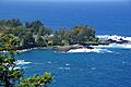
View of Laupāhoehoe Point from the highway
-
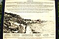
Road signage overlooking Laupāhoehoe Point
-
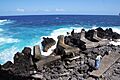
Concrete reinforcements at Laupāhoehoe
-

The breakwater and boat launch at Laupāhoehoe


See also
 In Spanish: Laupahoehoe para niños
