Laurel Hollow, New York facts for kids
Quick facts for kids
Laurel Hollow, New York
Lauralton, New York
|
|
|---|---|
| Incorporated Village of Laurel Hollow | |

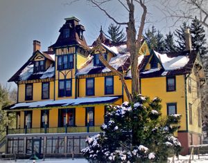
The Charles Davenport Residence in Laurel Hollow, part of the Cold Spring Harbor Laboratory.
|
|

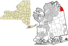
Location in Nassau County and the state of New York.
|
|
| Country | |
| State | |
| County | Nassau |
| Town | Oyster Bay |
| Incorporated | 1926 |
| Area | |
| • Total | 3.16 sq mi (8.19 km2) |
| • Land | 2.96 sq mi (7.66 km2) |
| • Water | 0.20 sq mi (0.53 km2) |
| Elevation | 240 ft (73 m) |
| Population
(2020)
|
|
| • Total | 1,940 |
| • Density | 655.85/sq mi (253.25/km2) |
| Time zone | UTC-5 (Eastern (EST)) |
| • Summer (DST) | UTC-4 (EDT) |
| ZIP codes |
11771, 11791, 11724, 11797
|
| Area codes | 516, 363 |
| FIPS code | 36-41487 |
| GNIS feature ID | 0955090 |
Laurel Hollow is a small village located in Nassau County, on the North Shore of Long Island, in New York, United States. It is part of the Town of Oyster Bay. In 2010, about 1,952 people lived there. Laurel Hollow is known for being one of the wealthiest towns in America.
Contents
History of Laurel Hollow
The area where Laurel Hollow is now located was first settled around 1653. This happened when land was bought from the local native people.
How Laurel Hollow Got Its Name
The village was officially created in 1926. It was first called "Lauralton." However, this name caused problems with mail delivery. People often confused it with Laurelton, a place in Queens. To fix this, the village's name was changed to "Laurel Hollow" in 1935. Today, mail for Laurel Hollow is handled by post offices in nearby areas like Syosset and Cold Spring Harbor.
Cold Spring Harbor Laboratory
Laurel Hollow is home to the famous Cold Spring Harbor Laboratory. This is a world-renowned research center. Scientists there study important topics like genetics and biology.
Geography of Laurel Hollow
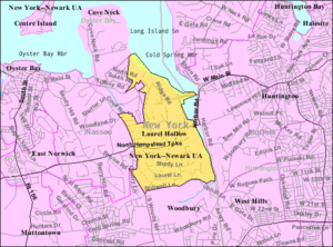
Laurel Hollow covers an area of about 3.1 square miles (8.1 square kilometers). Most of this area is land, about 2.9 square miles (7.6 square kilometers). The rest, about 0.2 square miles (0.5 square kilometers), is water.
Landscape and Location
The village is in Nassau County. It forms part of the border between Nassau County and Suffolk County. The land in Laurel Hollow is quite hilly. It has many deciduous trees, which lose their leaves in the fall. There are also many laurel bushes, which stay green all year. New York State Route 25A is a main road that runs through Laurel Hollow from east to west.
People of Laurel Hollow
| Historical population | |||
|---|---|---|---|
| Census | Pop. | %± | |
| 1930 | 161 | — | |
| 1940 | 110 | −31.7% | |
| 1950 | 169 | 53.6% | |
| 1960 | 834 | 393.5% | |
| 1970 | 1,401 | 68.0% | |
| 1980 | 1,527 | 9.0% | |
| 1990 | 1,748 | 14.5% | |
| 2000 | 1,930 | 10.4% | |
| 2010 | 1,952 | 1.1% | |
| 2020 | 1,940 | −0.6% | |
| U.S. Decennial Census | |||
In 2000, there were 1,930 people living in Laurel Hollow. Most families living there were married couples. Many households also had children under 18. The average household had about 3 people.
Population Facts
The population in Laurel Hollow is spread across different age groups. About 30% of the people were under 18 years old. About 13.5% were 65 years or older. The average age of people in the village was 41 years old. Many families in Laurel Hollow have very high incomes.
Education in Laurel Hollow
Most students in Laurel Hollow attend schools in the Cold Spring Harbor Central School District. This district is mainly located in Cold Spring Harbor. A smaller part of the village is served by the Oyster Bay-East Norwich Central School District.
Famous Places in Laurel Hollow
- Cold Spring Harbor Laboratory: This is a non-profit science center. It does important research and trains new scientists.
- Cold Spring Harbor Fish Hatchery and Aquarium: A fun place to learn about fish and marine life.
- Laurel Hollow Beach: A beach located on the western side of Cold Spring Harbor's inner harbor.
Notable People from Laurel Hollow
Many interesting people have lived in Laurel Hollow:
- Jay Gould: A very successful American railroad builder and investor. He was one of the richest people in U.S. history.
- John Lennon: A famous musician and member of The Beatles. He owned an estate in Laurel Hollow with his wife, Yoko Ono.
- Lindsay Lohan: An actress and TV personality who spent her early childhood in Laurel Hollow.
- Doug Morris: A very important person in the music industry. He used to be the head of Universal Music Group and Sony Music Entertainment.
- Louis Comfort Tiffany: A famous artist known for his beautiful glass vases, lamps, and windows. His art was often inspired by the views from his estate in Laurel Hollow.
- James D. Watson: A scientist who helped discover the structure of DNA. He was also a leader at Cold Spring Harbor Laboratory.
- Ned Lamont: The current Governor of Connecticut. He lived in Laurel Hollow during some of his childhood years.
See also
 In Spanish: Laurel Hollow para niños


