Le Poizat-Lalleyriat facts for kids
Quick facts for kids
Le Poizat-Lalleyriat
|
|
|---|---|
|
Commune
|
|

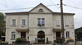
Town hall
|
|
| Country | France |
| Region | Auvergne-Rhône-Alpes |
| Department | Ain |
| Arrondissement | Nantua |
| Canton | Nantua |
| Intercommunality | Haut-Bugey Agglomération |
| Area
1
|
33.15 km2 (12.80 sq mi) |
| Population
(2021)
|
746 |
| • Density | 22.504/km2 (58.28/sq mi) |
| Time zone | UTC+01:00 (CET) |
| • Summer (DST) | UTC+02:00 (CEST) |
| INSEE/Postal code |
01204 /01130
|
| 1 French Land Register data, which excludes lakes, ponds, glaciers > 1 km2 (0.386 sq mi or 247 acres) and river estuaries. | |
Le Poizat-Lalleyriat is a small town, also known as a commune, located in eastern France. It's part of the Ain department, which is like a region or county. This town was created on January 1, 2016. It was formed by joining two older towns, Lalleyriat and Le Poizat, into one bigger community.
Contents
Exploring Le Poizat-Lalleyriat
Where is Le Poizat-Lalleyriat Located?
Le Poizat-Lalleyriat is found in the eastern part of France. It is in the Ain department. This area is known for its beautiful landscapes.
What is the Climate Like?
The town has an oceanic climate. This means it gets rain throughout the year. The summers are usually mild, and the winters are cool.
The average temperature for the whole year is about 8.3 degrees Celsius (47 degrees Fahrenheit). July is usually the warmest month, with temperatures around 17.6 degrees Celsius (63.7 degrees Fahrenheit). January is the coldest, averaging about 0.0 degrees Celsius (32 degrees Fahrenheit).
It rains quite a lot in Le Poizat-Lalleyriat. The average yearly rainfall is about 1752.5 millimeters (69 inches). December is often the wettest month.
The highest temperature ever recorded was 37.5 degrees Celsius (99.5 degrees Fahrenheit) on July 31, 1983. The coldest temperature ever recorded was -22.5 degrees Celsius (-8.5 degrees Fahrenheit) on January 9, 1985.
| Climate data for Lalleyriat, Le Poizat-Lalleyriat (1981–2010 averages, extremes 1981−1997) | |||||||||||||
|---|---|---|---|---|---|---|---|---|---|---|---|---|---|
| Month | Jan | Feb | Mar | Apr | May | Jun | Jul | Aug | Sep | Oct | Nov | Dec | Year |
| Record high °C (°F) | 13.5 (56.3) |
19.0 (66.2) |
23.0 (73.4) |
23.0 (73.4) |
26.0 (78.8) |
30.0 (86.0) |
37.5 (99.5) |
32.0 (89.6) |
30.0 (86.0) |
24.9 (76.8) |
21.0 (69.8) |
19.5 (67.1) |
37.5 (99.5) |
| Mean daily maximum °C (°F) | 2.9 (37.2) |
4.2 (39.6) |
7.9 (46.2) |
11.0 (51.8) |
15.8 (60.4) |
19.3 (66.7) |
23.2 (73.8) |
22.6 (72.7) |
18.0 (64.4) |
12.9 (55.2) |
7.0 (44.6) |
3.7 (38.7) |
12.4 (54.3) |
| Daily mean °C (°F) | 0.0 (32.0) |
0.8 (33.4) |
4.0 (39.2) |
6.6 (43.9) |
11.0 (51.8) |
14.4 (57.9) |
17.6 (63.7) |
17.2 (63.0) |
13.3 (55.9) |
9.2 (48.6) |
3.8 (38.8) |
0.9 (33.6) |
8.3 (46.9) |
| Mean daily minimum °C (°F) | −3.0 (26.6) |
−2.6 (27.3) |
0.0 (32.0) |
2.3 (36.1) |
6.3 (43.3) |
9.5 (49.1) |
12.1 (53.8) |
11.8 (53.2) |
8.7 (47.7) |
5.4 (41.7) |
0.7 (33.3) |
−1.8 (28.8) |
4.2 (39.6) |
| Record low °C (°F) | −22.5 (−8.5) |
−18.0 (−0.4) |
−12.0 (10.4) |
−8.0 (17.6) |
−3.0 (26.6) |
0.5 (32.9) |
3.0 (37.4) |
2.0 (35.6) |
0.0 (32.0) |
−6.0 (21.2) |
−14.0 (6.8) |
−14.5 (5.9) |
−22.5 (−8.5) |
| Average precipitation mm (inches) | 167.6 (6.60) |
150.8 (5.94) |
132.9 (5.23) |
131.5 (5.18) |
149.3 (5.88) |
125.4 (4.94) |
111.9 (4.41) |
114.8 (4.52) |
135.3 (5.33) |
166.6 (6.56) |
174.3 (6.86) |
192.1 (7.56) |
1,752.5 (69.00) |
| Average precipitation days (≥ 1.0 mm) | 12.6 | 11.7 | 11.6 | 11.7 | 13.8 | 11.2 | 9.5 | 10.2 | 9.9 | 12.4 | 12.1 | 12.8 | 139.5 |
| Source: Meteociel | |||||||||||||
See also
 In Spanish: Le Poizat-Lalleyriat para niños
 | Bayard Rustin |
 | Jeannette Carter |
 | Jeremiah A. Brown |


