
Leitha facts for kids
Quick facts for kids Leitha |
|
|---|---|

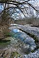
The Leitha near Kleinwolkersdorf
|
|

|
|
| Other name(s) | Lajta |
| Countries | Austria and Hungary |
| Physical characteristics | |
| Main source | Lanzenkirchen, southern Vienna Basin 47°44′11″N 16°13′49″E / 47.73639°N 16.23028°E |
| River mouth | Danube near Mosonmagyaróvár 47°52′8″N 17°17′17″E / 47.86889°N 17.28806°E |
| Length | 120.8 km (75.1 mi) |
| Basin features | |
| Progression | Danube→ Black Sea |
| Basin size | 2,138 km2 (825 sq mi) |
The Leitha is a river that flows through Austria and Hungary. It's a right branch of the big Danube River. The Leitha is about 120.8 kilometers (75 miles) long. If you include its source river, the Schwarza, it's even longer, at 168.5 kilometers (104.7 miles). The area of land that drains into the Leitha River is about 2,138 square kilometers (825 square miles).
Contents
What's in a Name?
The Leitha River was first written about in the year 833. This was in a document from Louis the German, a ruler from the Carolingian Empire. The old name for the river, Lithaha, might have come from an ancient word meaning "mud." This makes sense because its old Hungarian name, Sár, also meant "mud" or "swamp."
The River's Journey

The Leitha River starts in Lower Austria. It forms when two smaller rivers, the Schwarza and the Pitten, join together. The Schwarza River gets its water from the Schneeberg, Rax, and Schneealpe mountains.
For some parts of its journey, the Leitha River acts as a border. It separates the Austrian states of Lower Austria and Burgenland. This happens between places like Ebenfurth and Leithaprodersdorf, and again between Bruck an der Leitha and Gattendorf.
After flowing through Austria, the river crosses into Hungary. There, it joins a part of the Danube River near Mosonmagyaróvár. Some important towns along the Leitha include Wiener Neustadt, Bruck, and Mosonmagyaróvár.
Water Use and Dry Sections
A lot of water from the Schwarza River, which feeds the Leitha, is used for other things. It helps fill the Wiener Neustadt Canal. It also provides drinking water for the city of Vienna.
Many smaller channels also branch off from the Leitha. In the past, these channels powered factories that made cloth. Today, they often power small hydroelectric plants, which create electricity from moving water.
Because so much water is taken out, the Leitha River often runs dry. This happens especially between Seibersdorf and Hof am Leithaberge. Unless there's a lot of rain upstream, the riverbed can be almost completely dry in these areas. Downriver from Katzelsdorf, the riverbed is also usually dry.

Leitha Witches Legend

Near where the Leitha River begins in Lanzenkirchen, you can find a hiking trail. There's a stone with a plaque marking the river's starting point. You can also see three wooden figures that represent the legendary Leitha Hexen, or "witches."
A sign nearby tells their story: "Long ago, real witches lived in the waters of the Leitha. They were small, like children, thin and hunched over. Their hair was tangled and reached their knees, and they had webbed fingers and toes."
"These witches mostly played under the bridges. But if anyone teased them or watched them, something bad would happen."
One evening, a man decided to bother the Leitha witches. When he heard them in the water, he cupped his hands and shouted, "Hoo hoo!"
He quickly ran away, laughing. But he didn't get far! Suddenly, many bony hands grabbed him and pulled him to the ground. He couldn't get free or even call for help. He felt a wet cloth pressed over his mouth, and then he passed out.
When he woke up, he was lying on the riverbanks near Katzelsdorf. The Leitha witches were nowhere to be seen or heard.
A Historic Border River
The Leitha River has been an important border for a very long time. After the Hungarian people settled in the area in the late 800s, they sometimes tried to expand into nearby lands. But in 955, King Otto I defeated them in a big battle.
After this, the lands up to the Leitha River were gradually taken back. Around 976, a new area called the March of Austria was created along the river. From 1156 onwards, the Leitha became the eastern border of the Duchy of Austria. Fortresses were built along it in towns like Wiener Neustadt and Bruck.
In 1246, the last duke of Austria, Frederick II, was killed in a battle against the King of Hungary near the Leitha River. The border was officially confirmed again in 1411.
Cisleithania and Transleithania
The Leitha River gave its name to two important regions after 1867. This was when the Dual Monarchy was formed, creating Austria-Hungary.
- Cisleithania ("on this side of the Leitha") referred to the Austrian lands.
- Transleithania ("beyond the Leitha") referred to Hungary.
These names showed how people in Vienna (the capital of Austria) saw the empire. Vienna was on "this side" of the Leitha, and Hungary was on "that side." However, the Leitha didn't form the entire border between the two parts of the empire. For example, Galicia and Bukovina were part of Cisleithania but were northeast of Hungary.
After World War I, Austria-Hungary broke apart. In 1920, the Treaty of Trianon gave a part of western Hungary to Austria. This area became the Austrian state of Burgenland. Because of this, the Leitha River then became a border inside Austria, instead of between two countries.

See also
- Cisleithania
- Transleithania
Images for kids
-
Shallows along the Leitha River near Lanzenkirchen

