Lemsterland facts for kids
Quick facts for kids
Lemsterland
Lemsterlân
|
|||
|---|---|---|---|
|
Former municipality
|
|||

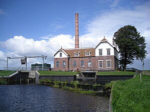
Pumping station in Echten
|
|||
|
|||

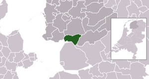
Location in Friesland
|
|||
| Country | Netherlands | ||
| Province | Friesland | ||
| Dissolved | 1 January 2014 | ||
| Area | |||
| • Total | 124.34 km2 (48.01 sq mi) | ||
| • Land | 75.93 km2 (29.32 sq mi) | ||
| • Water | 48.41 km2 (18.69 sq mi) | ||
| Elevation | 0 m (0 ft) | ||
| Population
(November 2013)
|
|||
| • Total | 13,544 | ||
| • Density | 178/km2 (460/sq mi) | ||
| Time zone | UTC+1 (CET) | ||
| • Summer (DST) | UTC+2 (CEST) | ||
| Postcode |
8508, 8530–8539
|
||
| Area code | 0514 | ||
Lemsterland was a municipality in the northern part of the Netherlands. It was located in the province of Friesland.
A municipality is like a local government area. It helps manage towns and villages.
In 2014, Lemsterland joined with two other municipalities. These were Skarsterlân and Gaasterlân-Sleat. Together, they formed a new, larger municipality. This new area is called De Fryske Marren.
Towns and Villages
Lemsterland was made up of several towns and villages. These places were part of the municipality.
Here are some of the main population centres:
- Bantega
- Delfstrahuizen
- Echten
- Echtenerbrug
- Eesterga
- Follega
- Lemmer
- Oosterzee
- Oosterzee-Buren
See also
 In Spanish: Lemsterland para niños
Black History Month on Kiddle
African-American Artists you should know:
 | John T. Biggers |
 | Thomas Blackshear |
 | Mark Bradford |
 | Beverly Buchanan |

All content from Kiddle encyclopedia articles (including the article images and facts) can be freely used under Attribution-ShareAlike license, unless stated otherwise. Cite this article:
Lemsterland Facts for Kids. Kiddle Encyclopedia.


