Lerderderg Gorge facts for kids
The Lerderderg Gorge is a really deep valley in Victoria, Australia. It was carved out by the Lerderderg River. This river starts in the Great Dividing Range mountains and winds its way down to the flat southern plains.
Contents
What is the Lerderderg Gorge?
The Lerderderg Gorge is part of the Lerderderg State Park. This park is next to the Wombat State Forest. You can find them north of a town called Bacchus Marsh. It's about an hour's drive (90 km or 56 miles) from Melbourne.
This area is wild and rugged. It has many tracks, gullies, creeks, and ridges. People love to visit for outdoor adventures. The most amazing part is the gorge itself. It's about 300 meters (975 feet) deep! It stretches all the way south to the plains near Bacchus Marsh.
Some parts of the Wombat State Forest are still used for logging trees. People can also collect firewood there with a special permit. Many roads in the Lerderderg State Park are closed from June to early November. This is because the park helps collect water for the area.
Exploring the Gorge: Bushwalking
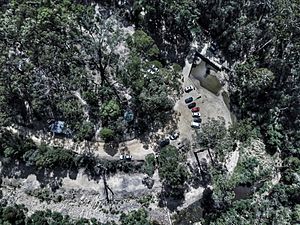
The park is a fantastic place for bushwalking (which is like hiking). You can walk all day and sometimes not see another person! The best places to start your adventure are Mackenzies Flat Picnic Area and O'Briens Crossing.
From Mackenzies Flat, a great walk goes up one side of the gorge and back along the other. It leads right up to the Lerderderg Weir. From O'Briens Crossing, you can walk either up or down the river. Walking upstream takes you to a cool spot called The Tunnel.
If you plan to walk along the river, make sure it hasn't rained too much recently. Also, it's usually easier to walk downhill along the river. This is because the bushes on the riverbed tend to slope downwards.
How to Get There
You can reach the Lerderderg Gorge from different directions:
- From the east: Take Bacchus Marsh-Gisborne Road and then Lerderderg Gorge Road to get to Mackenzies Flat picnic area.
- From the south-west: Go through Myrniong and Mt Blackwood.
- From the north-west: Use Greendale-Trentham Road and O'Brien's Road to reach O'Brien's Crossing.
In the past, some roads would often flood. But with less rain recently, they are usually safe to use now.
How the Gorge Was Formed
The Lerderderg Gorge was created by the Lerderderg River cutting through different rock layers. These layers were pushed up by big cracks in the Earth called faults. The sides of the gorge are often very steep, about 350 to 400 meters (1,138 to 1,300 feet) high. Some parts even have vertical rock cliffs up to 60 meters (195 feet) tall!
The area has long, narrow ridges and steep side spurs. You can see a lot of exposed rock on the tops of the ridges, slopes, and in the river channels. The main rocks here are sandstones and mudstones. They formed a very long time ago, during the Lower Ordovician period. These rocks also have many small quartz veins running through them.
The river flows steeply over boulders. It takes a winding path with several sharp, U-shaped bends called gooseneck meanders. This shows how powerful the river has been in shaping the land.
Importance of the Gorge
The Lerderderg Gorge is one of the most important river valleys in Victoria. It's a significant natural landmark.
 | Charles R. Drew |
 | Benjamin Banneker |
 | Jane C. Wright |
 | Roger Arliner Young |


