Lewisburg, Kentucky facts for kids
Quick facts for kids
Lewisburg, Kentucky
|
|
|---|---|

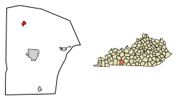
Location in Logan County, Kentucky
|
|
| Country | United States |
| State | Kentucky |
| County | Logan |
| Incorporated | 1878 |
| Named for | an O&N railroad engineer |
| Area | |
| • Total | 1.18 sq mi (3.05 km2) |
| • Land | 1.16 sq mi (3.01 km2) |
| • Water | 0.02 sq mi (0.04 km2) |
| Elevation | 479 ft (146 m) |
| Population
(2020)
|
|
| • Total | 748 |
| • Density | 643.72/sq mi (248.55/km2) |
| Time zone | UTC-6 (Central (CST)) |
| • Summer (DST) | UTC-5 (CDT) |
| ZIP code |
42256
|
| Area code(s) | 270 |
| FIPS code | 21-45064 |
| GNIS feature ID | 0496337 |
Lewisburg (/ˈluːɪsbɜːrɡ/) is a small city in Logan County, Kentucky, in the United States. It is known as a "home rule-class city," which means it has its own local government rules. In 2020, about 748 people lived there.
Contents
History of Lewisburg
Early Beginnings: Henrysville Post Office
The story of Lewisburg began in 1852. A local post office was set up near a place where stagecoaches used to stop. This place was called "Henrysville." It was named after the family of the person who ran the post office.
Founding by the Railroad
Later, in 1872, a railroad company called the Owensboro and Nashville Railroad decided to build a new town. They planned out the streets and lots for Lewisburg. The town was created to be a train station, also known as a depot, for their railway line.
Naming the City
The city was named after Eugene C. Lewis. He was the main engineer for the railroad line. In 1877, the post office from Henrysville moved to this new community. At that time, its name was changed to Lewisburg. The city officially became a town with its own government in 1878. This was approved by the state government, called the state assembly.
Geography of Lewisburg
Where Lewisburg is Located
Lewisburg is found in the northern part of Logan County. It is located at coordinates 36.985622 degrees North and -86.951059 degrees West.
Main Roads and Connections
U.S. Route 431 runs through the western part of Lewisburg. This road is known as Main Street in the city. If you go south on this road, you will reach Russellville, which is about 11 miles away. Russellville is the main town of Logan County. If you go north, you will get to Central City, about 26 miles away.
Another important road is Kentucky Route 106. It goes through the middle of Lewisburg and is called Stacker Street. This road leads northeast to Rochester, about 20 miles away. Going southwest on this road will take you to Elkton, which is about 18 miles away.
Land and Water Area
Lewisburg covers a total area of about 3.1 square kilometers (1.18 square miles). Most of this area is land. Only a small part, about 0.04 square kilometers (0.02 square miles), is water.
Population Changes in Lewisburg
Lewisburg has seen its population change over many years. Here's how the number of people living in the city has changed since 1880:
| Historical population | |||
|---|---|---|---|
| Census | Pop. | %± | |
| 1880 | 111 | — | |
| 1890 | 224 | 101.8% | |
| 1900 | 239 | 6.7% | |
| 1910 | 253 | 5.9% | |
| 1920 | 334 | 32.0% | |
| 1930 | 332 | −0.6% | |
| 1940 | 524 | 57.8% | |
| 1950 | 496 | −5.3% | |
| 1960 | 512 | 3.2% | |
| 1970 | 651 | 27.1% | |
| 1980 | 972 | 49.3% | |
| 1990 | 772 | −20.6% | |
| 2000 | 903 | 17.0% | |
| 2010 | 810 | −10.3% | |
| 2020 | 748 | −7.7% | |
| U.S. Decennial Census | |||
In 2000, there were 903 people living in Lewisburg. By 2010, the population had gone down to 810 people. The most recent count in 2020 showed 748 people living in the city.
See also
 In Spanish: Lewisburg (Kentucky) para niños
 | Jewel Prestage |
 | Ella Baker |
 | Fannie Lou Hamer |

